Difference between revisions of "2015-08-16 48 8"
imported>Klaus (my plans...) |
imported>FippeBot m (Location) |
||
| (7 intermediate revisions by 2 users not shown) | |||
| Line 1: | Line 1: | ||
| − | + | [[Image:{{{image|2015-08-16_48_8_view_from_hash_to_Wurmlingen.jpg}}}|thumb|left]] | |
| − | |||
| − | |||
| − | |||
| − | |||
| − | |||
| − | |||
| − | |||
{{meetup graticule | {{meetup graticule | ||
| lat=48 | | lat=48 | ||
| Line 23: | Line 16: | ||
== Participants == | == Participants == | ||
* [[User:Klaus|Klaus]] | * [[User:Klaus|Klaus]] | ||
| + | *[[User:RecentlyChanged|RecentlyChanged]] | ||
== Plans == | == Plans == | ||
| − | Klaus thinks, this one is too | + | === Klaus === |
| − | + | Klaus thinks, this one is too close to let go. | |
| + | Most likely a quite unspectacular hash, <strike>but will make a bike trip to it, starting in Tuebingen around 19:30, so I can travel back before sunset at ~21:00.</strike> | ||
| + | As it's probably raining, I'll not go by bike, but will make a short (few kilometres) detour at around 17:00, when I'm travelling from Herrenberg to Tuebingen by car anyway. | ||
| + | |||
| + | === RecentlyChanged === | ||
| + | I will go there this evening on my way home from Esslingen. I don't know yet when I will be there, but I don't think I will make it before sunset. | ||
== Expedition == | == Expedition == | ||
| − | + | ||
| + | === Klaus === | ||
| + | I was driving back from my origin graticule [[49,11]] to Tuebingen. Unfortunately I left a little late and I got stuck in two traffic jams :( Because I was driving, I didn't read RecentlyChanged's announcement, too. | ||
| + | |||
| + | So I just parked in Wurmlingen, walked the last few hundred meters to the geohash and got there at 19:34, shot a few pictures, and went back to the car. | ||
| + | |||
| + | Nothing special (as expected), the field was quite muddy, and a woman going for a walk with her 2 dogs noticed me from the far. I wonder what she must have thought when seeing me taking photos at the most uninteresting spot... but she didn't say anything when I came across her on my way back. | ||
| + | |||
| + | Anyway, I think I reached the exact spot, though the "proof" image of my garmin has the last few digits off (made that on the track, didn't want to be longer than necessary in this muddy field). The pictures show, that I actually went in the muddy field ;) | ||
| + | |||
| + | === RecentlyChanged === | ||
| + | I was there around 9pm and got easily into reach of the hash. I approached the hash from the east and can confirm that the fieldtrack and the field itself were really muddy. I was about 1 centimetre bigger when I returned to the car. (At home the next day, mom: "Where the hell where you hashing?". Damn.) | ||
| + | |||
| + | I can confirm the pictures klaus took, but the field did not show any signs of him walking in. I think that's good. I walked in too and hope that I didn't leave a sign either. I hoped to meet him, but really did not know when my expedition would start. Still it's nice to know that I wasn't the only one there that day. | ||
== Tracklog == | == Tracklog == | ||
<!-- if your GPS device keeps a log, you may post a link here --> | <!-- if your GPS device keeps a log, you may post a link here --> | ||
| + | Klaus has his tracklog below as image. | ||
| + | |||
| + | RecentlyChanged hasn't logged his track. | ||
== Photos == | == Photos == | ||
| − | + | ||
| − | |||
| − | |||
<gallery perrow="5"> | <gallery perrow="5"> | ||
| + | Image:2015-08-16_48_8_hash_from_far.jpg | The geohash is on the left, ploughed field | ||
| + | Image:2015-08-16_48_8_proof_klaus.jpg | Proof of Klaus | ||
| + | Image:2015-08-16_48_8_view_from_hash_to_Wurmlingen.jpg | view from hash to Wurmlingen | ||
| + | Image:2015-08-16_48_8_view_from_hash_to_wurmlinger_kapelle.jpg | view from hash to Wurmlinger Kapelle | ||
| + | Image:2015_08_16_48_8_tracklog_zoomlevel_13.png | Tracklog of Klaus | ||
| + | </gallery> | ||
| + | |||
| + | <gallery perrow="5"> | ||
| + | Image:2015-08-16 21.13.00.png | Proof of RecentlyChanged | ||
| + | Image:2015-08-16_48_8_Stupid_Grin.jpg | The stupid grin, looking east. The light of the flash burned my eyes (and killed the battery) | ||
| + | Image:2015-08-16_48_8_thefield.jpg | The hash at night | ||
</gallery> | </gallery> | ||
== Achievements == | == Achievements == | ||
{{#vardefine:ribbonwidth|800px}} | {{#vardefine:ribbonwidth|800px}} | ||
| + | {{land geohash | ||
| + | | latitude = 48 | ||
| + | | longitude = 8 | ||
| + | | date = 2015-08-16 | ||
| + | | name = [[User:Klaus|Klaus]] | ||
| + | }} | ||
| + | {{land geohash | ||
| + | | latitude = 48 | ||
| + | | longitude = 8 | ||
| + | | date = 2015-08-16 | ||
| + | | name = [[User:RecentlyChanged|RecentlyChanged]] | ||
| + | }} | ||
| − | |||
| − | |||
| − | |||
| − | |||
| − | |||
| − | |||
[[Category:Expeditions]] | [[Category:Expeditions]] | ||
| − | |||
[[Category:Expeditions with photos]] | [[Category:Expeditions with photos]] | ||
| − | |||
| − | |||
| − | |||
| − | |||
[[Category:Coordinates reached]] | [[Category:Coordinates reached]] | ||
| − | + | {{location|DE|BW|TÜ}} | |
| − | |||
| − | |||
| − | |||
| − | |||
| − | |||
| − | |||
| − | |||
| − | |||
| − | |||
| − | |||
| − | |||
| − | |||
| − | |||
| − | |||
| − | |||
| − | |||
| − | |||
Latest revision as of 04:49, 15 August 2019

| Sun 16 Aug 2015 in 48,8: 48.4949137, 8.9682920 geohashing.info google osm bing/os kml crox |
Location
on a field south of Wurmlingen. Seems easily accessible, as there is a track on google maps 1-2 meter north of the geohash.
Participants
Plans
Klaus
Klaus thinks, this one is too close to let go.
Most likely a quite unspectacular hash, but will make a bike trip to it, starting in Tuebingen around 19:30, so I can travel back before sunset at ~21:00.
As it's probably raining, I'll not go by bike, but will make a short (few kilometres) detour at around 17:00, when I'm travelling from Herrenberg to Tuebingen by car anyway.
RecentlyChanged
I will go there this evening on my way home from Esslingen. I don't know yet when I will be there, but I don't think I will make it before sunset.
Expedition
Klaus
I was driving back from my origin graticule 49,11 to Tuebingen. Unfortunately I left a little late and I got stuck in two traffic jams :( Because I was driving, I didn't read RecentlyChanged's announcement, too.
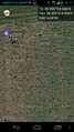
So I just parked in Wurmlingen, walked the last few hundred meters to the geohash and got there at 19:34, shot a few pictures, and went back to the car.
Nothing special (as expected), the field was quite muddy, and a woman going for a walk with her 2 dogs noticed me from the far. I wonder what she must have thought when seeing me taking photos at the most uninteresting spot... but she didn't say anything when I came across her on my way back.
Anyway, I think I reached the exact spot, though the "proof" image of my garmin has the last few digits off (made that on the track, didn't want to be longer than necessary in this muddy field). The pictures show, that I actually went in the muddy field ;)
RecentlyChanged
I was there around 9pm and got easily into reach of the hash. I approached the hash from the east and can confirm that the fieldtrack and the field itself were really muddy. I was about 1 centimetre bigger when I returned to the car. (At home the next day, mom: "Where the hell where you hashing?". Damn.)
I can confirm the pictures klaus took, but the field did not show any signs of him walking in. I think that's good. I walked in too and hope that I didn't leave a sign either. I hoped to meet him, but really did not know when my expedition would start. Still it's nice to know that I wasn't the only one there that day.
Tracklog
Klaus has his tracklog below as image.
RecentlyChanged hasn't logged his track.
Photos
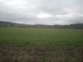
The geohash is on the left, ploughed field
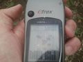
Proof of Klaus
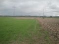
view from hash to Wurmlingen
view from hash to Wurmlinger Kapelle
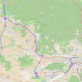
Tracklog of Klaus


Proof of RecentlyChanged

The stupid grin, looking east. The light of the flash burned my eyes (and killed the battery)
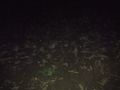
The hash at night


Achievements
Klaus earned the Land geohash achievement
|
RecentlyChanged earned the Land geohash achievement
|