Difference between revisions of "2015-08-16 54 16"
From Geohashing
imported>Klucken m |
imported>FippeBot m (Location) |
||
| (One intermediate revision by one other user not shown) | |||
| Line 28: | Line 28: | ||
Image:2015-08-16 54 16 p.jpg | human traces | Image:2015-08-16 54 16 p.jpg | human traces | ||
</gallery> | </gallery> | ||
| + | |||
| + | == Achievements == | ||
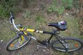
| + | {{bicycle geohash | ||
| + | | latitude = 54 | ||
| + | | longitude = 16 | ||
| + | | date = 2015-08-16 | ||
| + | | name = Klucken | ||
| + | | distance = 8.6km | ||
| + | | bothways = | ||
| + | | image = 2015-08-16 54 16 TB.jpg | ||
| + | }} | ||
| Line 33: | Line 44: | ||
[[Category:Expeditions with photos]] | [[Category:Expeditions with photos]] | ||
[[Category:Coordinates reached]] | [[Category:Coordinates reached]] | ||
| + | {{location|PL|G|SL}} | ||
Latest revision as of 04:49, 15 August 2019
| Sun 16 Aug 2015 in 54,16: 54.4949137, 16.9682920 geohashing.info google osm bing/os kml crox |
Location
The place is to the south of Strzelino, 5,5 km to the west of Słupsk.
Participants
Klucken (talk) 17:48, 16 August 2015 (EDT)
Plans
Expedition
Photos
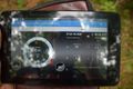
proof
view N
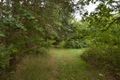
view E
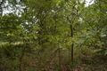
view S
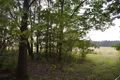
view W
my associate
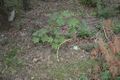
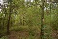
human traces


Achievements
Klucken earned the Bicycle geohash achievement
|