Difference between revisions of "2015-08-18 55 12"
imported>GeorgDerReisende m (typo) |
imported>FippeBot m (Location) |
||
| (7 intermediate revisions by 2 users not shown) | |||
| Line 4: | Line 4: | ||
| date=2015-08-18 | | date=2015-08-18 | ||
}} | }} | ||
| − | + | [[Image:{{{image|2015_08_18_55_12_hash5.jpg}}}|thumb|left]] | |
__NOTOC__ | __NOTOC__ | ||
| Line 11: | Line 11: | ||
== Participants == | == Participants == | ||
| − | [[User:Erik r|Erik | + | [[User:Erik r|Erik]], going solo this time |
== Plans == | == Plans == | ||
I'm on vacation here in Sweden, staying with family, and checked the hash coordinates the night of the seventeenth. I found they were just a few kilometers away from our place in Löddeköpinge, so I figured I'd bike there in the morning and be back in time for a late morning fika with the family. | I'm on vacation here in Sweden, staying with family, and checked the hash coordinates the night of the seventeenth. I found they were just a few kilometers away from our place in Löddeköpinge, so I figured I'd bike there in the morning and be back in time for a late morning fika with the family. | ||
== Expedition == | == Expedition == | ||
| − | This one went without a hitch! Obviously I didn't bring my trusty Trek bike to Sweden (not so trusty given my [[2015-01-16 37 -122|first hash attempt]] but hey) so, Johan Johansson being home (what your bike doesn't have a name?) I used | + | This one went without a hitch! Obviously I didn't bring my trusty Trek bike to Sweden (not so trusty given my [[2015-01-16 37 -122|first hash attempt]] but hey) so, Johan Johansson being home (what your bike doesn't have a name?) I used my grandfather's old cruiser. It was an easy ride up through Lödde, past a friend's plant nursery, and through a few little towns to the hash point. It was a beautiful late summer's day, and a nice morning ride. Quite windy though, which was a bit tough on the return trip. Anyway, I got there around 10:35, having left a bit after 10:00, and followed my phone to a little wooded area near a track where some people were on morning jogs or walks. As usual I haven't got a GPS device, rather expensive as they are, so Google Maps on the phone had to do but I'm pleased enough that I reached the spot. Anyway, at that point I took my photos, had a nice (windy) ride back, and that was it! |
| − | |||
== Photos == | == Photos == | ||
| Line 24: | Line 23: | ||
--> | --> | ||
<gallery perrow="5"> | <gallery perrow="5"> | ||
| + | Image:2015_08_18_55_12_view1.jpg|First view on the way | ||
| + | Image:2015_08_18_55_12_nursery.jpg|The Nursery Sign | ||
| + | Image:2015_08_18_55_12_view2.jpg|Almost there! | ||
| + | Image:2015_08_18_55_12_bike.jpg|Left the bike here | ||
| + | Image:2015_08_18_55_12_hash1.jpg|There it is! | ||
| + | Image:2015_08_18_55_12_hash2.jpg|The Hashpoint | ||
| + | Image:2015_08_18_55_12_hash3.jpg|Me at hashpoint | ||
| + | Image:2015_08_18_55_12_hash4.jpg|Me with wind hat | ||
| + | Image:2015_08_18_55_12_map.png|Google Maps Proof | ||
| + | Image:2015_08_18_55_12_map2.png|Google Maps Proof 2 | ||
| + | Image:2015_08_18_55_12_hash5.jpg|Headed Home | ||
</gallery> | </gallery> | ||
| Line 35: | Line 45: | ||
| longitude = 12 | | longitude = 12 | ||
| date = 2015-08-18 | | date = 2015-08-18 | ||
| − | | name = [[User:Erik_r| | + | | name = [[User:Erik_r|Erik r]] |
}} | }} | ||
{{bicycle geohash | {{bicycle geohash | ||
| Line 42: | Line 52: | ||
| longitude = 12 | | longitude = 12 | ||
| date = 2015-08-18 | | date = 2015-08-18 | ||
| − | | name = [[User:Erik_r| | + | | name = [[User:Erik_r|Erik r]] |
| distance = 16.6km (total) | | distance = 16.6km (total) | ||
| bothways = true | | bothways = true | ||
| Line 49: | Line 59: | ||
{{Globetrotter6 | {{Globetrotter6 | ||
| − | | name = [[User:Erik_r| | + | | name = [[User:Erik_r|Erik r]] |
| northamerica = true | | northamerica = true | ||
| europe = true | | europe = true | ||
| continents = 2 | | continents = 2 | ||
}} | }} | ||
| − | |||
| − | |||
[[Category:Expeditions]] | [[Category:Expeditions]] | ||
[[Category:Expeditions with photos]] | [[Category:Expeditions with photos]] | ||
[[Category:Coordinates reached]] | [[Category:Coordinates reached]] | ||
| + | {{location|SE|M}} | ||
Latest revision as of 04:50, 15 August 2019
| Tue 18 Aug 2015 in 55,12: 55.8106259, 12.9883459 geohashing.info google osm bing/os kml crox |

Location
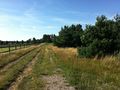
The hash is located in a little wooded area on the edges of Ålstorp, Sweden.
Participants
Erik, going solo this time
Plans
I'm on vacation here in Sweden, staying with family, and checked the hash coordinates the night of the seventeenth. I found they were just a few kilometers away from our place in Löddeköpinge, so I figured I'd bike there in the morning and be back in time for a late morning fika with the family.
Expedition
This one went without a hitch! Obviously I didn't bring my trusty Trek bike to Sweden (not so trusty given my first hash attempt but hey) so, Johan Johansson being home (what your bike doesn't have a name?) I used my grandfather's old cruiser. It was an easy ride up through Lödde, past a friend's plant nursery, and through a few little towns to the hash point. It was a beautiful late summer's day, and a nice morning ride. Quite windy though, which was a bit tough on the return trip. Anyway, I got there around 10:35, having left a bit after 10:00, and followed my phone to a little wooded area near a track where some people were on morning jogs or walks. As usual I haven't got a GPS device, rather expensive as they are, so Google Maps on the phone had to do but I'm pleased enough that I reached the spot. Anyway, at that point I took my photos, had a nice (windy) ride back, and that was it!
Photos
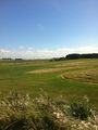
First view on the way
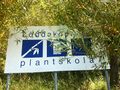
The Nursery Sign
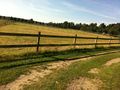
Almost there!
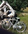
Left the bike here
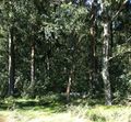
There it is!
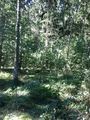
The Hashpoint
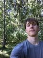
Me at hashpoint
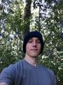
Me with wind hat
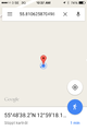
Google Maps Proof
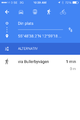
Google Maps Proof 2
Headed Home


Achievements
Erik r earned the Land geohash achievement
|
Erik r earned the Bicycle geohash achievement
|
Erik r earned the Globetrotter achievement
|