Difference between revisions of "2015-08-27 46 14"
From Geohashing
imported>B2c (Created page with "{{meetup graticule | lat=46 | lon=14 | date=2015-08-27 }} __NOTOC__ == Location == In a field near St. Margarethen im Rosental, in the south of Carinthia. == Participants...") |
imported>FippeBot m (Location) |
||
| (2 intermediate revisions by one other user not shown) | |||
| Line 25: | Line 25: | ||
== Photos == | == Photos == | ||
<gallery perrow="3"> | <gallery perrow="3"> | ||
| − | Image:2015-08-27_46_14-1.jpg | The hashpoint next to the | + | Image:2015-08-27_46_14-1.jpg | The hashpoint next to the telephone pole. |
Image:2015-08-27_46_14-2.jpg | View from the hashpoint back to the road. | Image:2015-08-27_46_14-2.jpg | View from the hashpoint back to the road. | ||
Image:2015-08-27_46_14-3.jpg | Some hashcows grazing nearby. | Image:2015-08-27_46_14-3.jpg | Some hashcows grazing nearby. | ||
| Line 37: | Line 37: | ||
[[Category:Expeditions with photos]] | [[Category:Expeditions with photos]] | ||
[[Category:Coordinates reached]] | [[Category:Coordinates reached]] | ||
| + | {{location|AT|K|KL}} | ||
Latest revision as of 00:52, 6 August 2019
| Thu 27 Aug 2015 in 46,14: 46.5380765, 14.4510463 geohashing.info google osm bing/os kml crox |
Location
In a field near St. Margarethen im Rosental, in the south of Carinthia.
Participants
Plans
Another spontaneous expedition - I was on my way back to Vienna when I noticed that a hashpoint was nearby and easily accessible.
Expedition
I parked the car under a tree next to the road and went through the meadow towards the hashpoint. Some electric fences separated grazing cows, but luckily the hashpoint was outside the pastures. I wandered around a bit and took some pictures and not before too long was on my way again.
Photos
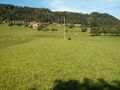
The hashpoint next to the telephone pole.
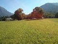
View from the hashpoint back to the road.
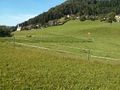
Some hashcows grazing nearby.

Stupid grin (tm).
Proof.
More proof.


