Difference between revisions of "2015-09-03 49 8"
imported>Tads (→Participants) |
imported>FippeBot m (Location) |
||
| (8 intermediate revisions by 2 users not shown) | |||
| Line 22: | Line 22: | ||
== Participants == | == Participants == | ||
| − | [[User:Tads|Tads]] | + | * [[User:Tads|Tads]] |
== Plans == | == Plans == | ||
| − | + | Tads considered going on his bike, the idea was to also visit Schloss Alsbach, Melibokus and Schloss Auerbach which are close by. | |
== Expedition == | == Expedition == | ||
| − | + | This expedition was tougher than those bike tours I usually do. The hashpoint was located at about 350m height in the woods. It was close to places which I some day wanted to visit anyway: [http://de.wikipedia.org/wiki/Schloss_Alsbach Schloss Alsbach], the [[wikipedia:Melibokus|Melibokus]] hill and [[wikipedia:Auerbach_Castle|Schloss Auerbach]]. Together this was enough incentive to start this expedition. | |
| + | |||
| + | I started in Darmstadt with the bike and first drove to Alsbach via Eberstadt, Malchen, Seeheim and Jugenheim. | ||
| + | From Alsbach (on about 120m) there is a steep ascent towards Schloss Alsbach, going up to 250m, which made me struggle already. I should improve my fitness regarding up-hill driving! | ||
| + | When I got there, I took a rest, ate and drank something and visited the castle. I could even ascend to the top of the old tower from where one has a panoramic view. | ||
| + | |||
| + | The next destination on my list was the hashpoint. I followed the navigation through the forest and further up the hill to come close to the hash location. Luckily, its position was right next to the forest path, so no climbing up or down the hill was necessary. At the spot I marked a tree with chalk and set up a stone arrow to point to the location. After taking photos I continued my way to the Melibokus. | ||
| + | |||
| + | The Melibokus is one of the highest hills (517m) in the southern part of Hessia. The observation deck which is located on top of the hill was closed. Still, I had a great view from the ground position. Close-by there is a launch platform for hang gliders. | ||
| + | |||
| + | The last destination was Schloss Auerbach. I beforehand did not look up a proper route to go there. So I took the first path into that direction going down the Melibokus hill, which turned out to be much too steep for me and my bike. I was happy when I came back onto a much more suitable path which quickly brought me to Schloss Auerbach that is located on the Auerberg (346m). | ||
| + | At Schloss Auerbach I had another long break, looked around, went on top of the towers and took lots of pictures. | ||
| + | |||
| + | Finally, I drove home to Darmstadt, via Zwingenberg, Bickenbach, Eberstadt. | ||
| + | |||
| + | All in all, it was a 52km tour with the bike, lasting about 6 hours. | ||
== Tracklog == | == Tracklog == | ||
| − | + | [https://www.google.com/maps/d/edit?mid=z4gnKDo1tzTs.kbFWFNZOyPmM&usp=sharing GPS log & map] | |
== Photos == | == Photos == | ||
| − | < | + | <gallery perrow="4"> |
| − | Image: | + | Image:tads_2015-09-03_49_8_spot.jpg | View to the spot, blackberries grow there |
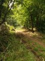
| − | -- | + | Image:tads_2015-09-03_49_8_north.jpg | View to the north |
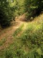
| − | + | Image:tads_2015-09-03_49_8_south.jpg | View to the south | |
| + | Image:tads_2015-09-03_49_8_west.jpg | View to the west | ||
| + | Image:tads_2015-09-03_49_8_proof.png | GPS proof | ||
| + | Image:tads_2015-09-03_49_8_marker.jpg | Chalk mark | ||
| + | Image:tads_2015-09-03_49_8_marker2.jpg | Stone arrow to the hash location | ||
</gallery> | </gallery> | ||
| Line 44: | Line 63: | ||
<!-- Add any achievement ribbons you earned below, or remove this section --> | <!-- Add any achievement ribbons you earned below, or remove this section --> | ||
| − | |||
| − | |||
| − | |||
| − | |||
| − | |||
| − | |||
| − | |||
| − | |||
| − | |||
| − | |||
| − | |||
| − | |||
[[Category:Expeditions]] | [[Category:Expeditions]] | ||
| − | |||
[[Category:Expeditions with photos]] | [[Category:Expeditions with photos]] | ||
| − | |||
| − | |||
| − | |||
| − | |||
| − | |||
[[Category:Coordinates reached]] | [[Category:Coordinates reached]] | ||
| − | + | {{location|DE|HE|DA}} | |
| − | |||
| − | |||
| − | |||
| − | |||
| − | |||
| − | |||
| − | |||
| − | |||
| − | |||
| − | |||
| − | |||
| − | |||
| − | |||
| − | |||
| − | |||
| − | |||
| − | |||
Latest revision as of 05:01, 15 August 2019
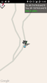
| Thu 3 Sep 2015 in 49,8: 49.7331961, 8.6424850 geohashing.info google osm bing/os kml crox |
Location
Almost on top of the Melibokus hill, in a wood close to Alsbach-Hähnlein.
Participants
Plans
Tads considered going on his bike, the idea was to also visit Schloss Alsbach, Melibokus and Schloss Auerbach which are close by.
Expedition
This expedition was tougher than those bike tours I usually do. The hashpoint was located at about 350m height in the woods. It was close to places which I some day wanted to visit anyway: Schloss Alsbach, the Melibokus hill and Schloss Auerbach. Together this was enough incentive to start this expedition.
I started in Darmstadt with the bike and first drove to Alsbach via Eberstadt, Malchen, Seeheim and Jugenheim. From Alsbach (on about 120m) there is a steep ascent towards Schloss Alsbach, going up to 250m, which made me struggle already. I should improve my fitness regarding up-hill driving! When I got there, I took a rest, ate and drank something and visited the castle. I could even ascend to the top of the old tower from where one has a panoramic view.
The next destination on my list was the hashpoint. I followed the navigation through the forest and further up the hill to come close to the hash location. Luckily, its position was right next to the forest path, so no climbing up or down the hill was necessary. At the spot I marked a tree with chalk and set up a stone arrow to point to the location. After taking photos I continued my way to the Melibokus.
The Melibokus is one of the highest hills (517m) in the southern part of Hessia. The observation deck which is located on top of the hill was closed. Still, I had a great view from the ground position. Close-by there is a launch platform for hang gliders.
The last destination was Schloss Auerbach. I beforehand did not look up a proper route to go there. So I took the first path into that direction going down the Melibokus hill, which turned out to be much too steep for me and my bike. I was happy when I came back onto a much more suitable path which quickly brought me to Schloss Auerbach that is located on the Auerberg (346m). At Schloss Auerbach I had another long break, looked around, went on top of the towers and took lots of pictures.
Finally, I drove home to Darmstadt, via Zwingenberg, Bickenbach, Eberstadt.
All in all, it was a 52km tour with the bike, lasting about 6 hours.
Tracklog
Photos
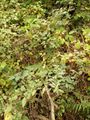
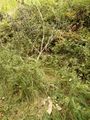
View to the spot, blackberries grow there
View to the north
View to the south
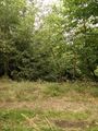
View to the west
GPS proof
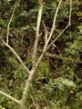
Chalk mark
Stone arrow to the hash location


