Difference between revisions of "2015-09-06 49 8"
imported>Elimik31 |
imported>FippeBot m (Location) |
||
| Line 33: | Line 33: | ||
[[Category:Expeditions]] | [[Category:Expeditions]] | ||
[[Category:Coordinates reached]] | [[Category:Coordinates reached]] | ||
| + | {{location|DE|BW|KA}} | ||
Latest revision as of 05:03, 15 August 2019
| Sun 6 Sep 2015 in 49,8: 49.1540900, 8.5764711 geohashing.info google osm bing/os kml crox |
Contents
Location
Near Bruchsal (20 km north of Karlsruhe) on a street in the small town "Forst".
Participants
Plans
Didn't plan much, the idea came spontaneously today because of boredom. I planned to cycle there and back, take a small detour on the way there to climb the 250 m high Turmberg, just for fun.
Expedition
Was a nice bycicle tour, went mostly according to plan. Except that I hadn't charged my phone correctly, so I couldn't take any photos. The way back home was in the dark. I "accidentally" road a closed road (due to construction work) and at some point I had to carry my bicycle over a guarding rail. So there was some adventure involved. Saw a deer, a hedgehog and two cats. Rode 63 km (39 miles) in total. Screenshot of track in gallery.
Photos
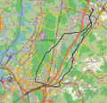
Screenshot of my 63 km track from QLandkarteGT with the openstreetbrowser map. I went "counterclockwise", not quite Troned it though.
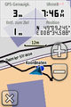
Proof. Screenshot of my Garmin device at the hash location.

