Difference between revisions of "2015-09-09 49 8"
imported>DODO (→Expedition) |
imported>FippeBot m (Location) |
||
| (3 intermediate revisions by one other user not shown) | |||
| Line 34: | Line 34: | ||
<!-- how it all turned out. your narrative goes here. --> | <!-- how it all turned out. your narrative goes here. --> | ||
If things seem to easy you instinctively put pepper in them by getting careless. And so I forgot every geohashing-equipement when I left home for work this morning. But todays hashpoint in my beloved graticule was so easy to reach that my ten years old mobile could do (at least it already has a gps-receptor). So I left work at 17:06 and arrived at the hashpoint ten minutes later. Just parked the car, walked to the corner, took some pictures and left again five minutes later. I arrived at Seckenheim at 17:28 but nevertheless came 10 minutes late to my date due to road works and the correspondent deviation, but thats already another story. | If things seem to easy you instinctively put pepper in them by getting careless. And so I forgot every geohashing-equipement when I left home for work this morning. But todays hashpoint in my beloved graticule was so easy to reach that my ten years old mobile could do (at least it already has a gps-receptor). So I left work at 17:06 and arrived at the hashpoint ten minutes later. Just parked the car, walked to the corner, took some pictures and left again five minutes later. I arrived at Seckenheim at 17:28 but nevertheless came 10 minutes late to my date due to road works and the correspondent deviation, but thats already another story. | ||
| + | |||
| + | I switched on the gps-receptor in my mobile when I have reached the hp, to proof that I've been there, but I did not use it to get there, so I think I've earned my first no batteries-achievement. | ||
== Tracklog == | == Tracklog == | ||
| Line 43: | Line 45: | ||
--> | --> | ||
<gallery perrow="5"> | <gallery perrow="5"> | ||
| + | Image:2015-09-09_49_8-1.jpg|proof | ||
| + | Image:2015-09-09_49_8-2.jpg|view to the west | ||
| + | Image:2015-09-09_49_8-3.jpg|view to the west with hasher in front | ||
| + | Image:2015-09-09_49_8-4.jpg|view to the east | ||
| + | Image:2015-09-09_49_8-5.jpg|view to the car (Northeast) | ||
</gallery> | </gallery> | ||
== Achievements == | == Achievements == | ||
{{#vardefine:ribbonwidth|800px}} | {{#vardefine:ribbonwidth|800px}} | ||
| − | |||
| − | |||
| − | |||
| − | |||
| − | |||
| − | + | {{land geohash | |
| − | + | | latitude = 49 | |
| − | + | | longitude = 8 | |
| − | + | | date = 2015-09-09 | |
| + | | name = DODO | ||
| + | }} | ||
| − | + | {{No_batteries_geohash | |
| + | | latitude = 49 | ||
| + | | longitude = 8 | ||
| + | | date = 2015-09-09 | ||
| + | | name = DODO | ||
| + | }} | ||
| − | |||
[[Category:Expeditions]] | [[Category:Expeditions]] | ||
| − | |||
[[Category:Expeditions with photos]] | [[Category:Expeditions with photos]] | ||
| − | |||
| − | |||
| − | |||
| − | |||
| − | |||
[[Category:Coordinates reached]] | [[Category:Coordinates reached]] | ||
| − | + | {{location|DE|BW|MA}} | |
| − | |||
| − | |||
| − | |||
| − | |||
| − | |||
| − | |||
| − | |||
| − | |||
| − | |||
| − | |||
| − | |||
| − | |||
| − | |||
| − | |||
| − | |||
| − | |||
| − | |||
Latest revision as of 05:04, 15 August 2019
| Wed 9 Sep 2015 in 49,8: 49.4702918, 8.4996732 geohashing.info google osm bing/os kml crox |
Location
On a road crossing in Mannheim-Neuhermsheim.
Participants
Plans
I have to drive to Seckenheim after work tomorrow and so it's a detour of less than 5 KM. That's far to easy not to go. ETA at 5 pm (or a quarter of an hour later).
Expedition
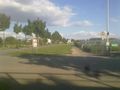
If things seem to easy you instinctively put pepper in them by getting careless. And so I forgot every geohashing-equipement when I left home for work this morning. But todays hashpoint in my beloved graticule was so easy to reach that my ten years old mobile could do (at least it already has a gps-receptor). So I left work at 17:06 and arrived at the hashpoint ten minutes later. Just parked the car, walked to the corner, took some pictures and left again five minutes later. I arrived at Seckenheim at 17:28 but nevertheless came 10 minutes late to my date due to road works and the correspondent deviation, but thats already another story.
I switched on the gps-receptor in my mobile when I have reached the hp, to proof that I've been there, but I did not use it to get there, so I think I've earned my first no batteries-achievement.
Tracklog
Photos

proof

view to the west

view to the west with hasher in front
view to the east
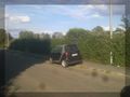
view to the car (Northeast)


Achievements
DODO earned the Land geohash achievement
|
DODO earned the No Batteries Geohash Achievement
|