Difference between revisions of "2015-09-12 52 0"
From Geohashing
imported>Sourcerer m ([live] Arrived.) |
imported>Sourcerer m ([live picture] Proof. [http://www.openstreetmap.org/?lat=52.11931765&lon=.79495311&zoom=16&layers=B000FTF @52.1193,.7950]) |
||
| Line 27: | Line 27: | ||
<gallery perrow="5"> | <gallery perrow="5"> | ||
| + | |||
| + | Image:2015-09-12_52_0_Sourcerer_1442095791289.jpg | Proof. [http://www.openstreetmap.org/?lat=52.11931765&lon=.79495311&zoom=16&layers=B000FTF @52.1193,.7950] | ||
</gallery> | </gallery> | ||
Revision as of 22:11, 12 September 2015
| Sat 12 Sep 2015 in 52,0: 52.1193204, 0.7949829 geohashing.info google osm bing/os kml crox |
Location
A field perimeter point north of Lavenham, Suffolk, UK - telephone.scraper.question.
Participants
Plans
Expedition one of two spanning midnight - 2015-09-12 52 0 - 2015-09-13 52 0 - ETA 23:20.
Expedition
- Arrived. -- Sourcerer (talk) @52.1193,.7950 23:10, 12 September 2015 (GMT+01:00)
Photos
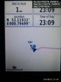
Proof. @52.1193,.7950

Achievements
Sourcerer earned the OpenStreetMap achievement
|
Expeditions and Plans
| 2015-09-12 | ||
|---|---|---|
| Crookston, Minnesota | Someone went | Somewhere near Fargo |
| Swindon, United Kingdom | SpiritofMaurice | A field in Wiltshire, just north of Salisbury and the ancient fortification... |
| Dresden, Germany | Danatar | in the forest a few meters from a Fäkalienannahmestation ("fecal matter... |
| Cambridge, United Kingdom | Sourcerer | A field perimeter point north of Lavenham, Suffolk, UK - telephone.scraper.question... |
Sourcerer's Expedition Links
2015-09-11 52 1 - 2015-09-12 52 0 - 2015-09-13 52 0 - KML file download of Sourcerer's expeditions for use with Google Earth.