Difference between revisions of "2015-09-15 52 0"
imported>SpiritofMaurice (small update still needs finishing tomorrow, images to upload. goodnight world!) |
imported>FippeBot m (Location) |
||
| (5 intermediate revisions by 2 users not shown) | |||
| Line 3: | Line 3: | ||
| lon=0 | | lon=0 | ||
| date=2015-09-15 | | date=2015-09-15 | ||
| + | | graticule_name=Cambridge, UK | ||
| + | | graticule_link=Cambridge, United Kingdom | ||
}} | }} | ||
| Line 21: | Line 23: | ||
== Expedition == | == Expedition == | ||
| − | + | Although it was the middle of nowhere, this was only 200m off a public lane across empty farmland, so it was almost too simple. | |
| + | |||
| + | Navigation consisted of simply opening the co-ordinates on Google Maps and asking for driving directions. It was a stormy afternoon when we set off, with brilliant blue skies clashing against towering thunderclouds; we decided to chance having the roof down on the convertible and watched leaden grey sheets of torrential rain sweeping along a few miles away as we drove along wet roads in beautiful sunshine. | ||
| + | With few hills in Norfolk, the sky feels bigger here. The drive alone was worth getting out of the house for (thanks geohashing). | ||
| + | |||
| + | At the designated point, things felt even easier - there was an entrance right onto the field, and a large concrete hard-standing pad (kind of like a car park) to get off the road and leave the car on. Aside from a few bales of hay, no real signs of civilisation. No fences either! | ||
| + | |||
| + | We started following a bearing down a muddy lane with hedges either side, and at this point realised we had hilariously impractical shoes for an afternoon in very wet Norfolk mud. Live and learn. 200m down said lane, the hashpoint was showing as 8m directly North through the hedge - d'oh! Got it wrong, it was in the field itself, not on the adjacent track. | ||
| + | |||
| + | 200m back to the end of the lane and 200m along the edge of the field, the crop recently harvested, leaving only soil. (More muddy feet.) The hashpoint was in the grass verge, where we grabbed a couple of pictures. | ||
| + | |||
| + | Afterwards, it seemed rude not to visit the nearby North Norfolk Area of Outstanding Natural Beauty near Wells-next-the-Sea - where the beach looked like this: | ||
| + | [[File:11849779 833762580069259 2023267612 n.jpg]] | ||
| + | |||
| + | https://instagram.com/p/7qnz0TrMoo/?taken-by=adventuresandsuch | ||
| + | |||
| + | Ended the day with dinner in a pub after sunset. Geohashing took me out of the house to a place I would never otherwise have seen! | ||
== Photos == | == Photos == | ||
<gallery perrow="5"> | <gallery perrow="5"> | ||
| − | Image: | + | Image:Screenshot 2015-09-15-17-50-26.jpg | Hope this screenshot from Geohash Droid suffices for evidence |
| + | Image:20150915 175145.jpg | Izzy and I at the hashpoint | ||
| + | Image:20150915 175159.jpg | Izzy and I at the hashpoint | ||
| + | Image:20150915 175249-.jpg | A panoramic shot of the surroundings, as seen from the hashpoint | ||
| + | Image:20150915 175322.jpg | Wet feet! | ||
</gallery> | </gallery> | ||
| Line 37: | Line 59: | ||
| date = 2015-09-15 | | date = 2015-09-15 | ||
| name = SpiritofMaurice | | name = SpiritofMaurice | ||
| − | |||
}} | }} | ||
| Line 46: | Line 67: | ||
| partner = Izzy | | partner = Izzy | ||
| name = SpiritofMaurice | | name = SpiritofMaurice | ||
| − | |||
}} | }} | ||
[[Category:Expeditions]] | [[Category:Expeditions]] | ||
| + | [[Category:Coordinates reached]] | ||
[[Category:Expeditions with photos]] | [[Category:Expeditions with photos]] | ||
| + | {{location|GB|ENG|NFK}} | ||
Latest revision as of 05:08, 15 August 2019
| Tue 15 Sep 2015 in Cambridge, UK: 52.9080816, 0.9468776 geohashing.info google osm bing/os kml crox |
Location
A field just outside the North Norfolk Area of Outstanding Natural Beauty; more specifically, just south of Wells-next-the-Sea.
Participants
+1, dragged along Izzy for her first ever geohash
Plans
Explained geohashing to my girlfriend after my failed first ever expedition three days previously, and as luck would have it, today's hashpoint was conveniently(ish) located near(ish) her house!
Expedition
Although it was the middle of nowhere, this was only 200m off a public lane across empty farmland, so it was almost too simple.
Navigation consisted of simply opening the co-ordinates on Google Maps and asking for driving directions. It was a stormy afternoon when we set off, with brilliant blue skies clashing against towering thunderclouds; we decided to chance having the roof down on the convertible and watched leaden grey sheets of torrential rain sweeping along a few miles away as we drove along wet roads in beautiful sunshine. With few hills in Norfolk, the sky feels bigger here. The drive alone was worth getting out of the house for (thanks geohashing).
At the designated point, things felt even easier - there was an entrance right onto the field, and a large concrete hard-standing pad (kind of like a car park) to get off the road and leave the car on. Aside from a few bales of hay, no real signs of civilisation. No fences either!
We started following a bearing down a muddy lane with hedges either side, and at this point realised we had hilariously impractical shoes for an afternoon in very wet Norfolk mud. Live and learn. 200m down said lane, the hashpoint was showing as 8m directly North through the hedge - d'oh! Got it wrong, it was in the field itself, not on the adjacent track.
200m back to the end of the lane and 200m along the edge of the field, the crop recently harvested, leaving only soil. (More muddy feet.) The hashpoint was in the grass verge, where we grabbed a couple of pictures.
Afterwards, it seemed rude not to visit the nearby North Norfolk Area of Outstanding Natural Beauty near Wells-next-the-Sea - where the beach looked like this:

https://instagram.com/p/7qnz0TrMoo/?taken-by=adventuresandsuch
Ended the day with dinner in a pub after sunset. Geohashing took me out of the house to a place I would never otherwise have seen!
Photos
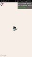
Hope this screenshot from Geohash Droid suffices for evidence

Izzy and I at the hashpoint

Izzy and I at the hashpoint
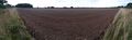
A panoramic shot of the surroundings, as seen from the hashpoint
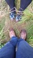
Wet feet!


Achievements
SpiritofMaurice earned the Land geohash achievement
|
SpiritofMaurice earned the Drag-along achievement
|