Difference between revisions of "2015-09-19 52 5"
From Geohashing
imported>Blauwe BIC (Created page with "{{subst:Expedition |lat = 52 |lon = 5 |date = 2015-09-19}}") |
imported>Blauwe BIC (Expedition filled in) |
||
| Line 1: | Line 1: | ||
| − | |||
| − | |||
| − | |||
[[Image:{{{image|IMAGE}}}|thumb|left]] | [[Image:{{{image|IMAGE}}}|thumb|left]] | ||
| − | |||
| − | |||
| − | |||
| − | |||
| − | |||
{{meetup graticule | {{meetup graticule | ||
| lat=52 | | lat=52 | ||
| Line 15: | Line 7: | ||
}} | }} | ||
| − | |||
__NOTOC__ | __NOTOC__ | ||
== Location == | == Location == | ||
| − | + | Exactly on a railway track between Harderwijk and Nunspeet | |
== Participants == | == Participants == | ||
| − | + | [[user:Blauwe_BIC|Blauwe BIC]] | |
| − | |||
== Plans == | == Plans == | ||
| − | + | Take a train, earn the public transport achievement in the best possible way (i.e. not walk the last bit from the station or bus stop to the coordinates, but let the entire train itself get there). | |
== Expedition == | == Expedition == | ||
| − | + | Well, quite a boring story if you ask me. The train was on time, everything went as planned. | |
| − | |||
| − | |||
| − | |||
== Photos == | == Photos == | ||
| − | < | + | <gallery perrow="4"> |
| − | Image: | + | Image:2015-09-19_52_5_Intercity.jpg | This is the train I'm taking. |
| − | -- | + | Image:2015-09-19_52_5_Focus_issues.jpg | This is a still from a video that's supposed to be the proof. I haven't been able to upload the video yet. |
| − | + | Image:2015-09-19_52_5_Bonus.jpg | Bonus photo. | |
</gallery> | </gallery> | ||
== Achievements == | == Achievements == | ||
{{#vardefine:ribbonwidth|800px}} | {{#vardefine:ribbonwidth|800px}} | ||
| − | + | {{Public transport geohash | |
| − | + | | latitude = 52 | |
| − | + | | longitude = 5 | |
| − | + | | date = 2015-09-19 | |
| + | | busline = NS intercity 543 | ||
| + | | name = Blauwe BIC | ||
| + | }} | ||
| − | |||
| − | |||
| − | |||
| − | |||
| − | |||
| − | |||
| − | |||
| − | |||
[[Category:Expeditions]] | [[Category:Expeditions]] | ||
| − | |||
[[Category:Expeditions with photos]] | [[Category:Expeditions with photos]] | ||
| − | [[Category: | + | [[Category:Meetup on 2015-09-19]] |
| − | [[Category: | + | [[Category:Meetup in 52 5]] |
| − | |||
| − | |||
| − | |||
[[Category:Coordinates reached]] | [[Category:Coordinates reached]] | ||
| − | |||
| − | |||
| − | |||
| − | |||
| − | |||
| − | |||
| − | |||
| − | |||
| − | |||
| − | |||
| − | |||
| − | |||
| − | |||
| − | |||
| − | |||
| − | |||
| − | |||
| − | |||
Revision as of 14:38, 19 September 2015
| Sat 19 Sep 2015 in 52,5: 52.3624325, 5.7613624 geohashing.info google osm bing/os kml crox |
Location
Exactly on a railway track between Harderwijk and Nunspeet
Participants
Plans
Take a train, earn the public transport achievement in the best possible way (i.e. not walk the last bit from the station or bus stop to the coordinates, but let the entire train itself get there).
Expedition
Well, quite a boring story if you ask me. The train was on time, everything went as planned.
Photos
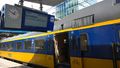
This is the train I'm taking.
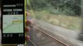
This is a still from a video that's supposed to be the proof. I haven't been able to upload the video yet.
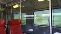
Bonus photo.


Achievements
Blauwe BIC earned the Public transport geohash achievement
|