Difference between revisions of "2015-09-20 55 37"
imported>Alexey Nigin |
imported>FippeBot m (Location) |
||
| (11 intermediate revisions by one other user not shown) | |||
| Line 21: | Line 21: | ||
<!-- where you've surveyed the hash to be --> | <!-- where you've surveyed the hash to be --> | ||
| − | + | That Geohash is located within the Losiniy Ostrov National Park (Национальный Парк Лосиный Остров), on a glade, near (but fortunately not within) some guarded place. | |
== Participants == | == Participants == | ||
<!-- who attended: If you link to your wiki user name in this section, your expedition will be picked up by the various statistics generated for geohashing. You may use three tildes ~ as a shortcut to automatically insert the user signature of the account you are editing with. | <!-- who attended: If you link to your wiki user name in this section, your expedition will be picked up by the various statistics generated for geohashing. You may use three tildes ~ as a shortcut to automatically insert the user signature of the account you are editing with. | ||
--> | --> | ||
| + | [[User:Alexey Nigin|Alexey Nigin]] ([[User talk:Alexey Nigin|talk]]) | ||
== Plans == | == Plans == | ||
<!-- what were the original plans --> | <!-- what were the original plans --> | ||
| − | [[User:Alexey Nigin|Alexey Nigin]] | + | [[User:Alexey Nigin|Alexey Nigin]] initially wanted to get there by noon and meet other Geohashers. |
== Expedition == | == Expedition == | ||
<!-- how it all turned out. your narrative goes here. --> | <!-- how it all turned out. your narrative goes here. --> | ||
| + | The expedition began at my countryhouse, which is located 10 km to the North of Geohash. At 10:43 I sat atop my bicycle, not forgetting to take useful things such as my phone, [[Marker|marker]] and candies. (In case you were wondering, I have switched from third-person to first-person narrative, but I am still the same [[User:Alexey Nigin|Alexey Nigin]].) I traversed most of the distance just fine: I rode the bike in my favourite hands-free manner, breathed fresh air and occasionally stopped to make a photo of something. But then the problems began to appear, replicate, breed and multiply at ever-increasing rate. To begin with, it's no secret that there are few good roads in Russian forests. I didn't manage to find one; fortunately, I got a pretty good substitute: a high-voltage power line. Trees below such lines are cut for safety reasons, so I could ride more or less normally. | ||
| − | == Tracklog == | + | At some point I realised that I should get off the road to reach the Geohash. ('''Definition:''' In Russia, a ''road'' is any place without trees.) I locked my bicycle and masked it with grass. The first few hundred meters walked on foot were easy: I just walked. But soon a wall consisting of raspberry plants (without raspberries) and nettle (also without raspberries) rose in front of me. Breaking through it was really hard: I fought for every meter, and my legs quickly became very itchy. All of a sudden, that horror ended and I faced a neat forest with grass at the bottom. "Ok, I will go there", I thought. Step, step, step, splash! I realised I was actually walking across a swamp. Anyway, wet legs were not such a problem for me, so I continued to go. |
| + | |||
| + | I walked and walked. At some moment, I saw a fence in front of me. The fence was too high to see what was on the other side, but in any case, it was certain that I shouldn't have gone there, and I didn't. After going along the fence (which was easy, as nettle refused to grow there for some reason) I reached a large glade, with the Geohash right in the middle. Nobody was there, so I had nothing to do other than the normal routine. Marker got glued, photos got taken, and I started a long way back. | ||
| + | |||
| + | 5 hours and 22 minutes after the start, I, tired and thirsty, arrived back home to eat an abnormally large dinner. All in all, I thoroughly enjoyed the experience, and it was probably the most difficult physical exercise I have ever had. | ||
| + | |||
| + | <!-- == Tracklog == --> | ||
<!-- if your GPS device keeps a log, you may post a link here --> | <!-- if your GPS device keeps a log, you may post a link here --> | ||
| Line 41: | Line 49: | ||
Image:2012-##-## ## ## Alpha.jpg | Witty Comment | Image:2012-##-## ## ## Alpha.jpg | Witty Comment | ||
--> | --> | ||
| − | <gallery perrow=" | + | <gallery perrow="3"> |
| + | Image:Nigin-1-1.jpg | At the very beginning, I crossed a river. | ||
| + | Image:Nigin-1-2.jpg | Then I crossed a railway. | ||
| + | Image:Nigin-1-3.jpg | Riding below a high-voltage power line. | ||
| + | Image:Nigin-1-4.jpg | Can you find my bike in this image? | ||
| + | Image:Nigin-1-5.jpg | Are there any special prizes for collecting mushrooms along the way? | ||
| + | Image:Nigin-1-6.jpg | The swamp. | ||
| + | Image:Nigin-1-7.png | Reached! | ||
| + | Image:Nigin-1-8.jpg | The marker. | ||
| + | Image:Nigin-1-9.jpg | Selfie! | ||
</gallery> | </gallery> | ||
| Line 47: | Line 64: | ||
{{#vardefine:ribbonwidth|800px}} | {{#vardefine:ribbonwidth|800px}} | ||
<!-- Add any achievement ribbons you earned below, or remove this section --> | <!-- Add any achievement ribbons you earned below, or remove this section --> | ||
| + | {{land geohash | ||
| + | | latitude = 55 | ||
| + | | longitude = 37 | ||
| + | | date = 2015-09-20 | ||
| + | | name = Alexey Nigin | ||
| + | }} | ||
| + | {{bicycle geohash | ||
| + | | latitude = 55 | ||
| + | | longitude = 37 | ||
| + | | date = 2015-09-20 | ||
| + | | name = Alexey Nigin | ||
| + | | distance = 27.53 km | ||
| + | | bothways = true | ||
| + | }} | ||
<!-- =============== USEFUL CATEGORIES FOLLOW ================ | <!-- =============== USEFUL CATEGORIES FOLLOW ================ | ||
Delete the next line ONLY if you have chosen the appropriate categories below. If you are unsure, don't worry. People will read your report and help you with the classification. --> | Delete the next line ONLY if you have chosen the appropriate categories below. If you are unsure, don't worry. People will read your report and help you with the classification. --> | ||
| − | [[Category:New report]] | + | <!-- [[Category:New report]] --> |
<!-- Potential categories. Please include all the ones appropriate to your expedition --> | <!-- Potential categories. Please include all the ones appropriate to your expedition --> | ||
| Line 88: | Line 119: | ||
(Don't forget to delete this final close comment marker) --> | (Don't forget to delete this final close comment marker) --> | ||
| − | [[Category: | + | [[Category:Expeditions]] |
| + | [[Category:Expeditions with photos]] | ||
| + | [[Category:Coordinates reached]] | ||
| + | {{location|RU|MOS}} | ||
Latest revision as of 05:12, 15 August 2019
| Sun 20 Sep 2015 in 55,37: 55.8488893, 37.9247735 geohashing.info google osm bing/os kml crox |
Location
That Geohash is located within the Losiniy Ostrov National Park (Национальный Парк Лосиный Остров), on a glade, near (but fortunately not within) some guarded place.
Participants
Plans
Alexey Nigin initially wanted to get there by noon and meet other Geohashers.
Expedition
The expedition began at my countryhouse, which is located 10 km to the North of Geohash. At 10:43 I sat atop my bicycle, not forgetting to take useful things such as my phone, marker and candies. (In case you were wondering, I have switched from third-person to first-person narrative, but I am still the same Alexey Nigin.) I traversed most of the distance just fine: I rode the bike in my favourite hands-free manner, breathed fresh air and occasionally stopped to make a photo of something. But then the problems began to appear, replicate, breed and multiply at ever-increasing rate. To begin with, it's no secret that there are few good roads in Russian forests. I didn't manage to find one; fortunately, I got a pretty good substitute: a high-voltage power line. Trees below such lines are cut for safety reasons, so I could ride more or less normally.
At some point I realised that I should get off the road to reach the Geohash. (Definition: In Russia, a road is any place without trees.) I locked my bicycle and masked it with grass. The first few hundred meters walked on foot were easy: I just walked. But soon a wall consisting of raspberry plants (without raspberries) and nettle (also without raspberries) rose in front of me. Breaking through it was really hard: I fought for every meter, and my legs quickly became very itchy. All of a sudden, that horror ended and I faced a neat forest with grass at the bottom. "Ok, I will go there", I thought. Step, step, step, splash! I realised I was actually walking across a swamp. Anyway, wet legs were not such a problem for me, so I continued to go.
I walked and walked. At some moment, I saw a fence in front of me. The fence was too high to see what was on the other side, but in any case, it was certain that I shouldn't have gone there, and I didn't. After going along the fence (which was easy, as nettle refused to grow there for some reason) I reached a large glade, with the Geohash right in the middle. Nobody was there, so I had nothing to do other than the normal routine. Marker got glued, photos got taken, and I started a long way back.
5 hours and 22 minutes after the start, I, tired and thirsty, arrived back home to eat an abnormally large dinner. All in all, I thoroughly enjoyed the experience, and it was probably the most difficult physical exercise I have ever had.
Photos
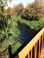
At the very beginning, I crossed a river.
Then I crossed a railway.
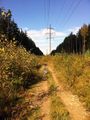
Riding below a high-voltage power line.
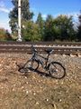
Can you find my bike in this image?
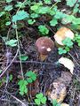
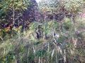
Are there any special prizes for collecting mushrooms along the way?
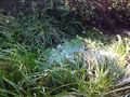
The swamp.

Reached!
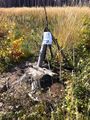
The marker.
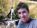
Selfie!


Achievements
Alexey Nigin earned the Land geohash achievement
|
Alexey Nigin earned the Bicycle geohash achievement
|