Difference between revisions of "2015-10-04 -13 131"
From Geohashing
imported>Felix Dance (Created page) |
imported>Felix Dance (Added proof) |
||
| Line 24: | Line 24: | ||
Image:Geohash 2015 10 04 -13 131 Bikes.JPG|Bikes collected at the hash | Image:Geohash 2015 10 04 -13 131 Bikes.JPG|Bikes collected at the hash | ||
Image:Geohash 2015 10 04 -13 131 Hashshot.JPG|Felix and Alex at the hash | Image:Geohash 2015 10 04 -13 131 Hashshot.JPG|Felix and Alex at the hash | ||
| + | Image:Geohash 2015 10 04 -13 131 Proof.JPG|GPS Phone app proof | ||
Image:Geohash 2015 10 04 -13 131 Beer.JPG|Adelaide River celebratory beer | Image:Geohash 2015 10 04 -13 131 Beer.JPG|Adelaide River celebratory beer | ||
Image:Geohash 2015 10 04 -13 131 Ride.JPG|Alex riding to Robyn Falls | Image:Geohash 2015 10 04 -13 131 Ride.JPG|Alex riding to Robyn Falls | ||
Revision as of 09:15, 4 October 2015
| Sun 4 Oct 2015 in -13,131: -13.4769097, 131.3807025 geohashing.info google osm bing/os kml crox |
Location
In the bush near Hayes Creek, just off the Stuart Highway.
Participants
- Felix Dance
- Alex
Expedition
We rode 6.6kms and reached the hash at 11:45am.
Here is the route of our trip.
Photos
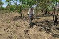
Alex riding to the hash
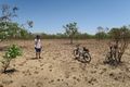
Bikes collected at the hash
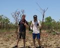
Felix and Alex at the hash
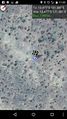
GPS Phone app proof

Adelaide River celebratory beer
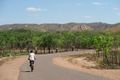
Alex riding to Robyn Falls


