Difference between revisions of "2015-10-04 49 8"
imported>DODO (Created page with "{{subst:Expedition |lat = 49 |lon = 8 |date = 2015-10-04 }}") |
imported>FippeBot m (Location) |
||
| (8 intermediate revisions by 2 users not shown) | |||
| Line 20: | Line 20: | ||
== Location == | == Location == | ||
<!-- where you've surveyed the hash to be --> | <!-- where you've surveyed the hash to be --> | ||
| + | On a corn field near Ludwigshafen-Oggersheim. | ||
== Participants == | == Participants == | ||
<!-- who attended: If you link to your wiki user name in this section, your expedition will be picked up by the various statistics generated for geohashing. You may use three tildes ~ as a shortcut to automatically insert the user signature of the account you are editing with. | <!-- who attended: If you link to your wiki user name in this section, your expedition will be picked up by the various statistics generated for geohashing. You may use three tildes ~ as a shortcut to automatically insert the user signature of the account you are editing with. | ||
--> | --> | ||
| + | [[User:DODO|DODO]] | ||
== Plans == | == Plans == | ||
<!-- what were the original plans --> | <!-- what were the original plans --> | ||
| + | Go there by bike. Trying a tron. | ||
== Expedition == | == Expedition == | ||
<!-- how it all turned out. your narrative goes here. --> | <!-- how it all turned out. your narrative goes here. --> | ||
| + | It was raining all morning long and so I wasn't sure if I should go for a drowned rat or stay at home. But at 1 pm the rain stopped, and at 13:30 I sat on my bike. At the beginning everything went as planned, but a kilometer before I reached the hash I had to ride along an asphalted road that was covered by a thin layer of soft mud and it covered my bike and me all over. So after a while I had to stop and trying to clean the bike a little bit. When I came near the hashpoint it was on a harvested cornfield and was quite easy to reach. Of course my shoes get also muddy but it was a totally different kind of mud. The one at the bike was very soft and almost fluid. So you could hardly remove it with a stick as it was too soft. The mud at the shoes again was very hard and it was difficult to remove it with the stick, as I hardly could get into it. | ||
| + | |||
| + | You see there isn't much to tell about the hash. On my way back I found a really nice cafe and had some cake. After three hours and almost 50 KM I reached home again. | ||
== Tracklog == | == Tracklog == | ||
<!-- if your GPS device keeps a log, you may post a link here --> | <!-- if your GPS device keeps a log, you may post a link here --> | ||
| + | [https://www.komoot.de/tour/7050673 47 KM by bike] | ||
== Photos == | == Photos == | ||
| Line 38: | Line 45: | ||
Image:2012-##-## ## ## Alpha.jpg | Witty Comment | Image:2012-##-## ## ## Alpha.jpg | Witty Comment | ||
--> | --> | ||
| − | <gallery perrow=" | + | <gallery perrow="6"> |
| + | Image:2015-10-04_49_8-1.jpg|dirty bike | ||
| + | Image:2015-10-04_49_8-2.jpg|view to the hash... | ||
| + | Image:2015-10-04_49_8-3.jpg|48m into the field | ||
| + | Image:2015-10-04_49_8-4.jpg|48 m later: the proof | ||
| + | Image:2015-10-04_49_8-11.png|another proof | ||
| + | Image:2015-10-04_49_8-5.jpg|view back to the bike | ||
| + | Image:2015-10-04_49_8-6.jpg|view to Oggersheim | ||
| + | Image:2015-10-04_49_8-8.jpg|stupid grin | ||
| + | Image:2015-10-04_49_8-7.jpg|the bike seen from the cafe (still dirty) | ||
| + | Image:2015-10-04_49_8-9.jpg|coffee and sacher | ||
| + | Image:2015-10-04_49_8-10.jpg|the interior of the cafe | ||
</gallery> | </gallery> | ||
| Line 44: | Line 62: | ||
{{#vardefine:ribbonwidth|800px}} | {{#vardefine:ribbonwidth|800px}} | ||
<!-- Add any achievement ribbons you earned below, or remove this section --> | <!-- Add any achievement ribbons you earned below, or remove this section --> | ||
| + | {{land geohash | ||
| + | | latitude = 49 | ||
| + | | longitude = 8 | ||
| + | | date = 2015-10-04 | ||
| + | | name = DODO | ||
| + | }} | ||
| − | + | {{Template:Tron | |
| − | + | | latitude = 49 | |
| − | + | | longitude = 8 | |
| + | | date = 2015-10-04 | ||
| + | | name = DODO | ||
| + | | possessive = his | ||
| + | }} | ||
| − | + | {{bicycle geohash | |
| − | + | | latitude = 49 | |
| − | + | | longitude = 8 | |
| − | + | | date = 2015-10-04 | |
| + | | name = DODO | ||
| + | | distance = 47 KM | ||
| + | }} | ||
| − | |||
| − | |||
[[Category:Expeditions]] | [[Category:Expeditions]] | ||
| − | |||
[[Category:Expeditions with photos]] | [[Category:Expeditions with photos]] | ||
| − | |||
| − | |||
| − | |||
| − | |||
| − | |||
[[Category:Coordinates reached]] | [[Category:Coordinates reached]] | ||
| − | + | {{location|DE|RP|LU}} | |
| − | |||
| − | |||
| − | |||
| − | |||
| − | |||
| − | |||
| − | |||
| − | |||
| − | |||
| − | |||
| − | |||
| − | |||
| − | |||
| − | |||
| − | |||
| − | |||
| − | |||
Latest revision as of 05:22, 15 August 2019
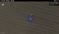
| Sun 4 Oct 2015 in 49,8: 49.4769097, 8.3807025 geohashing.info google osm bing/os kml crox |
Location
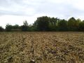
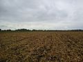
On a corn field near Ludwigshafen-Oggersheim.
Participants
Plans
Go there by bike. Trying a tron.
Expedition
It was raining all morning long and so I wasn't sure if I should go for a drowned rat or stay at home. But at 1 pm the rain stopped, and at 13:30 I sat on my bike. At the beginning everything went as planned, but a kilometer before I reached the hash I had to ride along an asphalted road that was covered by a thin layer of soft mud and it covered my bike and me all over. So after a while I had to stop and trying to clean the bike a little bit. When I came near the hashpoint it was on a harvested cornfield and was quite easy to reach. Of course my shoes get also muddy but it was a totally different kind of mud. The one at the bike was very soft and almost fluid. So you could hardly remove it with a stick as it was too soft. The mud at the shoes again was very hard and it was difficult to remove it with the stick, as I hardly could get into it.
You see there isn't much to tell about the hash. On my way back I found a really nice cafe and had some cake. After three hours and almost 50 KM I reached home again.
Tracklog
Photos
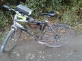
dirty bike
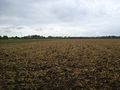
view to the hash...
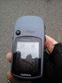
48m into the field
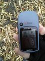
48 m later: the proof
another proof
view back to the bike
view to Oggersheim
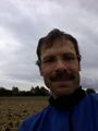
stupid grin
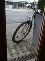
the bike seen from the cafe (still dirty)
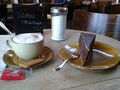
coffee and sacher
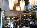
the interior of the cafe


Achievements
DODO earned the Land geohash achievement
|
DODO earned the Tron achievement
|
DODO earned the Bicycle geohash achievement
|