Difference between revisions of "2015-10-04 52 1"
From Geohashing
imported>Sourcerer m ([live] Arrived.) |
imported>Sourcerer m ([live picture] Proof. [http://www.openstreetmap.org/?lat=52.47690976&lon=1.38071537&zoom=16&layers=B000FTF @52.4769,1.3807]) |
||
| Line 27: | Line 27: | ||
<gallery> | <gallery> | ||
| + | |||
| + | Image:2015-10-04_52_1_Sourcerer_1443991429959.jpg | Proof. [http://www.openstreetmap.org/?lat=52.47690976&lon=1.38071537&zoom=16&layers=B000FTF @52.4769,1.3807] | ||
</gallery> | </gallery> | ||
Revision as of 20:45, 4 October 2015
| Sun 4 Oct 2015 in 52,1: 52.4769097, 1.3807025 geohashing.info google osm bing/os kml crox |
Location
In a field close to home, east of Cobblers's Green, Norfolk, UK.
Participants
Plans
Expedition
- Arrived. -- Sourcerer (talk) @52.4769,1.3807 21:44, 4 October 2015 (GMT+01:00)
Photos
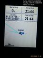
Proof. @52.4769,1.3807

Achievements
Sourcerer earned the OpenStreetMap achievement
|
Expeditions and Plans
| 2015-10-04 | ||
|---|---|---|
| Batchelor, Australia | Felix Dance, Alex | In the bush near Hayes Creek, just off the Stuart Highway. |
| Orlando, Florida | Geoff, Erica | On the road of a suburb next to Lake Mary Jess. Continue down from Bimini a... |
| Daytona Beach, Florida | Geoff, Erica | Just off Highway 100. Looks like it's not on property, so we can walk out a... |
| Mannheim, Germany | DODO | On a corn field near Ludwigshafen-Oggersheim. |
| Norwich, United Kingdom | Sourcerer | In a field close to home, east of Cobblers's Green, Norfolk, UK. alternate.flown.survivor... |
Sourcerer's Expedition Links
2015-09-30 52 1 - 2015-10-04 52 1 - 2015-10-06 52 1 - KML file download of Sourcerer's expeditions for use with Google Earth.