Difference between revisions of "2015-10-09 52 4"
imported>FelixTheCat |
imported>FippeBot m (Location) |
||
| (3 intermediate revisions by 2 users not shown) | |||
| Line 9: | Line 9: | ||
== Participants == | == Participants == | ||
| − | [[User:FelixTheCat|FelixTheCat]] | + | |
| + | * [[User:FelixTheCat|FelixTheCat]] | ||
== Plans == | == Plans == | ||
| Line 19: | Line 20: | ||
== Photos == | == Photos == | ||
<gallery perrow="5"> | <gallery perrow="5"> | ||
| − | Image:2015-10-09 52 4 FelixTheCat 1.JPG | The hash is right at the edge | + | Image:2015-10-09 52 4 FelixTheCat 1.JPG | The hash is right at the edge of the water. |
Image:2015-10-09 52 4 FelixTheCat 2.JPG | Standing on the edge. | Image:2015-10-09 52 4 FelixTheCat 2.JPG | Standing on the edge. | ||
Image:2015-10-09 52 4 FelixTheCat 3.JPG | Lloyd happy to reach the hash. | Image:2015-10-09 52 4 FelixTheCat 3.JPG | Lloyd happy to reach the hash. | ||
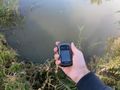
Image:2015-10-09 52 4 FelixTheCat 4.png | GPS proof. | Image:2015-10-09 52 4 FelixTheCat 4.png | GPS proof. | ||
Image:2015-10-09 52 4 FelixTheCat 5.JPG | View of the polder. | Image:2015-10-09 52 4 FelixTheCat 5.JPG | View of the polder. | ||
| − | Image:2015-10-09 52 4 FelixTheCat 6.JPG | These signs show the water | + | Image:2015-10-09 52 4 FelixTheCat 6.JPG | These signs show the ground and water levels through the ages (with an offset to prevent them from having to dig below the current ground level). Currently we're about 1.5 - 2 metres below sea level. |
</gallery> | </gallery> | ||
| Line 34: | Line 35: | ||
| longitude = 4 | | longitude = 4 | ||
| date = 2015-10-09 | | date = 2015-10-09 | ||
| − | | name = [[User:FelixTheCat|FelixTheCat]] | + | | name = [[User:FelixTheCat|FelixTheCat]] |
| distance = 15.8 km | | distance = 15.8 km | ||
| bothways = true | | bothways = true | ||
| Line 42: | Line 43: | ||
[[Category:Expeditions with photos]] | [[Category:Expeditions with photos]] | ||
[[Category:Coordinates reached]] | [[Category:Coordinates reached]] | ||
| + | {{location|NL|ZH}} | ||
Latest revision as of 05:24, 15 August 2019
| Fri 9 Oct 2015 in 52,4: 52.0049153, 4.3013955 geohashing.info google osm bing/os kml crox |
Location
Den Hoorn, municipality of Midden-Delfland.
Participants
Plans
Judging from Google Maps, the hash appeared to be in water. But it was close to home and easy to get to, so I thought I'd try it and see how close I could get.
Expedition
Got on my bike and rode towards the hash. It was located right at the edge of a pond/stream behind some glasshouses (where they grow cucumbers, tomatoes and apparently also grapes; who knew?). I walked as close to the water as I dared (tricky because the edge wasn't very sturdy), and I did manage to get within the margin of error of my GPS. Took a few pictures and rode home again.
Photos
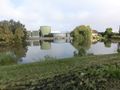
The hash is right at the edge of the water.
Standing on the edge.
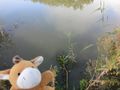
Lloyd happy to reach the hash.
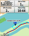
GPS proof.
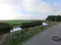
View of the polder.
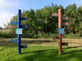
These signs show the ground and water levels through the ages (with an offset to prevent them from having to dig below the current ground level). Currently we're about 1.5 - 2 metres below sea level.


Achievements
FelixTheCat earned the Bicycle geohash achievement
|