Difference between revisions of "2015-10-19 54 17"
From Geohashing
imported>Klucken m (→Expedition) |
imported>Klucken m (→Photos) |
||
| Line 20: | Line 20: | ||
<gallery perrow="5"> | <gallery perrow="5"> | ||
Image:2015-10-19 54 17 proof.jpg | Zero! | Image:2015-10-19 54 17 proof.jpg | Zero! | ||
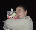
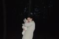
| − | Image:2015-10-19 54 17 Alexander i Joanna.jpg | Alexander | + | Image:2015-10-19 54 17 Alexander i Joanna.jpg | Alexander and Joanna on the hashpoint |
| − | Image:2015-10-19 54 17 Alex i Joanna.jpg | Alexander | + | Image:2015-10-19 54 17 Alex i Joanna.jpg | Alexander and Joanna on the hashpoint |
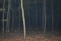
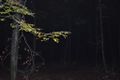
Image:2015-10-19 54 17 view N.jpg | on the north | Image:2015-10-19 54 17 view N.jpg | on the north | ||
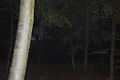
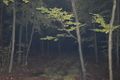
Image:2015-10-19 54 17 view E.jpg | on the east | Image:2015-10-19 54 17 view E.jpg | on the east | ||
Revision as of 21:20, 19 October 2015
| Mon 19 Oct 2015 in 54,17: 54.5751203, 17.0535245 geohashing.info google osm bing/os kml crox |
Location
A forest between the villages named Objazda and Karżcino.
Participants
Expedition
We arrived to the forest, where the geohash was located this day, from Ustka. We left our car next to the forester's house, took Alex and then walked 1 km to the point. It was simply near the forest road. Tom took some photos, standing on coordinates. Then we created there a geocashe which shows the idea of geohash and promote it. When we were going back to the car, it was almost completely dark and very foggy.
Photos

Zero!
Alexander and Joanna on the hashpoint
Alexander and Joanna on the hashpoint
on the north
on the east
on the south
on the west


