Difference between revisions of "2015-10-23 49 8"
From Geohashing
imported>DODO (→Expedition) |
imported>FippeBot m (Location) |
||
| (2 intermediate revisions by one other user not shown) | |||
| Line 43: | Line 43: | ||
--> | --> | ||
<gallery perrow="5"> | <gallery perrow="5"> | ||
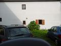
| + | Image:2015-10-23_49_8-1.jpg|a little more than 4 KM from work | ||
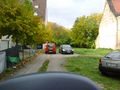
| + | Image:2015-10-23_49_8-2.jpg|view to the hash. Its on the parking space at the end of the road in the gap between the houses | ||
| + | Image:2015-10-23_49_8-3.jpg|proof | ||
| + | Image:2015-10-23_49_8-4.jpg|stupid grin | ||
| + | Image:2015-10-23_49_8-5.jpg|view to the east (and my car) | ||
| + | Image:2015-10-23_49_8-6.jpg|view to the south | ||
| + | Image:2015-10-23_49_8-7.jpg|and to the west | ||
</gallery> | </gallery> | ||
| Line 48: | Line 55: | ||
{{#vardefine:ribbonwidth|800px}} | {{#vardefine:ribbonwidth|800px}} | ||
<!-- Add any achievement ribbons you earned below, or remove this section --> | <!-- Add any achievement ribbons you earned below, or remove this section --> | ||
| + | {{land geohash | ||
| + | | latitude = 49 | ||
| + | | longitude = 8 | ||
| + | | date = 2015-10-23 | ||
| + | | name = DODO | ||
| + | }} | ||
| − | |||
| − | |||
| − | |||
| − | |||
| − | |||
| − | |||
| − | |||
| − | |||
| − | |||
| − | |||
| − | |||
[[Category:Expeditions]] | [[Category:Expeditions]] | ||
| − | |||
[[Category:Expeditions with photos]] | [[Category:Expeditions with photos]] | ||
| − | |||
| − | |||
| − | |||
| − | |||
| − | |||
[[Category:Coordinates reached]] | [[Category:Coordinates reached]] | ||
| − | + | {{location|DE|BW|MA}} | |
| − | |||
| − | |||
| − | |||
| − | |||
| − | |||
| − | |||
| − | |||
| − | |||
| − | |||
| − | |||
| − | |||
| − | |||
| − | |||
| − | |||
| − | |||
| − | |||
| − | |||
Latest revision as of 05:33, 15 August 2019
| Fri 23 Oct 2015 in 49,8: 49.4405648, 8.5756894 geohashing.info google osm bing/os kml crox |
Location
A parking space in Mannheim-Friedrichsfeld
Participants
Plans
I have to drive to my mothers 79th birthday after work and come along on my way. My mother lives nearly exactly one graticule north-west from me, and todays cashpoint is just around 4 KM from work, so I can try to visit another point today.
Expedition
This one was one of the most easy and fastest hashes I ever visited. I left work around 3 pm, and was near the hash at 15:15. Just parked the car and walked the remaining 30 m. I took some photos and left again at 15:25.
Tracklog
Photos
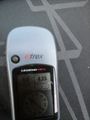
a little more than 4 KM from work
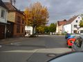
view to the hash. Its on the parking space at the end of the road in the gap between the houses
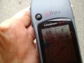
proof

stupid grin
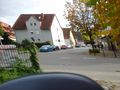
view to the east (and my car)
view to the south
and to the west


Achievements
DODO earned the Land geohash achievement
|