Difference between revisions of "2015-10-24 48 9"
imported>MisterFog (→Photos) |
imported>FippeBot m (Location) |
||
| (9 intermediate revisions by one other user not shown) | |||
| Line 20: | Line 20: | ||
== Location == | == Location == | ||
<!-- where you've surveyed the hash to be --> | <!-- where you've surveyed the hash to be --> | ||
| − | near by | + | near by Burladingen, Swabian Alb |
== Participants == | == Participants == | ||
<!-- who attended: If you link to your wiki user name in this section, your expedition will be picked up by the various statistics generated for geohashing. You may use three tildes ~ as a shortcut to automatically insert the user signature of the account you are editing with. | <!-- who attended: If you link to your wiki user name in this section, your expedition will be picked up by the various statistics generated for geohashing. You may use three tildes ~ as a shortcut to automatically insert the user signature of the account you are editing with. | ||
--> | --> | ||
| − | * [[User: | + | * [[User:MisterFog|MisterFog]] |
== Plans == | == Plans == | ||
| Line 33: | Line 33: | ||
== Expedition == | == Expedition == | ||
<!-- how it all turned out. your narrative goes here. --> | <!-- how it all turned out. your narrative goes here. --> | ||
| − | + | This was my frst hashpoint! | |
| + | |||
| + | Okay, there are 15m left, but I didn't want to enter a very new powed acre, because I thought that the farmer does not find as nice. | ||
| + | |||
| + | It was a glorious autumn day with very warm temperatures. So it was a must to go out. I had to go by car, because Burladingen is not so far to Reutlingen, but it was a nice trip. | ||
| + | I found a parking lot and I have to go about 600m by foot to reach the hashpoint. | ||
| + | |||
| + | It was very nice to go Geohashing and I hope I can get the next hashpoint very soon. | ||
== Photos == | == Photos == | ||
| Line 39: | Line 46: | ||
Image:2012-##-## ## ## Alpha.jpg | Witty Comment | Image:2012-##-## ## ## Alpha.jpg | Witty Comment | ||
--> | --> | ||
| − | |||
<gallery perrow="5"> | <gallery perrow="5"> | ||
| + | Image: 2015_10_24_48_9_150548.jpg|15m left, but I don't wont to enter the acre, because it was freshly plowed | ||
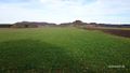
| + | Image: 2015_10_24_48_9_150627.jpg|The freshly plowed acre | ||
| + | Image: 2015_10_24_48_9_145832.jpg|Prepared for the next winter | ||
| + | Image: 2015_10_24_48_9_151030.jpg|Near by | ||
| + | Image: 2015_10_24_48_9_151046.jpg|Resting place | ||
| + | Image: 2015_10_24_48_9_151059.jpg|Very nice view sitting on the seating bench | ||
</gallery> | </gallery> | ||
| Line 51: | Line 63: | ||
| longitude = 9 | | longitude = 9 | ||
| date = 2015-10-24 | | date = 2015-10-24 | ||
| − | | name = [[User: | + | | name = [[User:MisterFog|MisterFog]] |
}} | }} | ||
| − | |||
| − | |||
| − | |||
| − | |||
| − | |||
| − | |||
| − | |||
| − | |||
| − | |||
| − | |||
| − | |||
[[Category:Expeditions]] | [[Category:Expeditions]] | ||
| − | |||
[[Category:Expeditions with photos]] | [[Category:Expeditions with photos]] | ||
| − | |||
| − | |||
| − | |||
| − | |||
| − | |||
[[Category:Coordinates reached]] | [[Category:Coordinates reached]] | ||
| − | + | {{location|DE|BW|BL}} | |
| − | |||
| − | |||
| − | |||
| − | |||
| − | |||
| − | |||
| − | |||
| − | |||
| − | |||
| − | |||
| − | |||
| − | |||
| − | |||
| − | |||
| − | |||
| − | |||
| − | |||
Latest revision as of 01:23, 7 August 2019
| Sat 24 Oct 2015 in 48,9: 48.3388878, 9.0897548 geohashing.info google osm bing/os kml crox |
Location
near by Burladingen, Swabian Alb
Participants
Plans
plan to find my first hashpoint :-) ... done.
Expedition
This was my frst hashpoint!
Okay, there are 15m left, but I didn't want to enter a very new powed acre, because I thought that the farmer does not find as nice.
It was a glorious autumn day with very warm temperatures. So it was a must to go out. I had to go by car, because Burladingen is not so far to Reutlingen, but it was a nice trip. I found a parking lot and I have to go about 600m by foot to reach the hashpoint.
It was very nice to go Geohashing and I hope I can get the next hashpoint very soon.
Photos
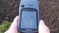
15m left, but I don't wont to enter the acre, because it was freshly plowed
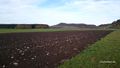
The freshly plowed acre
Prepared for the next winter
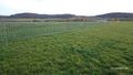
Near by
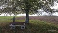
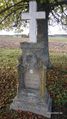
Resting place
Very nice view sitting on the seating bench


Achievements
MisterFog earned the Land geohash achievement
|