Difference between revisions of "2015-11-01 49 8"
From Geohashing
imported>DODO (→Photos) |
imported>FippeBot m (Location) |
||
| (One intermediate revision by one other user not shown) | |||
| Line 55: | Line 55: | ||
{{#vardefine:ribbonwidth|800px}} | {{#vardefine:ribbonwidth|800px}} | ||
<!-- Add any achievement ribbons you earned below, or remove this section --> | <!-- Add any achievement ribbons you earned below, or remove this section --> | ||
| + | {{land geohash | ||
| + | | latitude = 49 | ||
| + | | longitude = 8 | ||
| + | | date = 2015-11-01 | ||
| + | | name = DODO | ||
| + | }} | ||
| − | |||
| − | |||
| − | |||
| − | |||
| − | |||
| − | |||
| − | |||
| − | |||
| − | |||
| − | |||
| − | |||
[[Category:Expeditions]] | [[Category:Expeditions]] | ||
| − | |||
[[Category:Expeditions with photos]] | [[Category:Expeditions with photos]] | ||
| − | |||
| − | |||
| − | |||
| − | |||
| − | |||
[[Category:Coordinates reached]] | [[Category:Coordinates reached]] | ||
| − | + | {{location|DE|BW|KA}} | |
| − | |||
| − | |||
| − | |||
| − | |||
| − | |||
| − | |||
| − | |||
| − | |||
| − | |||
| − | |||
| − | |||
| − | |||
| − | |||
| − | |||
| − | |||
| − | |||
| − | |||
Latest revision as of 05:39, 15 August 2019
| Sun 1 Nov 2015 in 49,8: 49.1049902, 8.6330509 geohashing.info google osm bing/os kml crox |
Location
A field near Bruchsal.
Participants
Plans
It was already past 2 pm when I could start, and so I decided to go there on my bull. It's a 70 KM-ride so it will take almost 3 hours.
Expedition
Everything went pretty much as planned. I arrived in Bruchsal at a quarter past three and was close to the hashpoint some minutes later. I stopped the bull next to a field with sunflowers and rapeseed on the left, but the hash was on a harvested cornfield to my right. I only had to walk into the field for 7 m and reached a zero. I left a mark and continued my way home. At ten past five I reached home again.
Tracklog
Photos
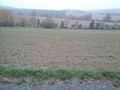
view to the hash (7 m into that field)
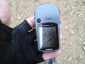
proof (didn't catch the 0)
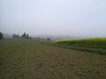
view from hash to bull
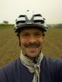
view from hash to happy hasher
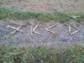
mark
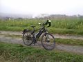
bull with sunflowers and Bruchsal in the background


Achievements
DODO earned the Land geohash achievement
|