Difference between revisions of "2015-11-06 52 1"
From Geohashing
imported>Sourcerer m ([live] Arrived.) |
imported>Sourcerer m ([live picture] Proof. [http://www.openstreetmap.org/?lat=52.10342824&lon=1.47010803&zoom=16&layers=B000FTF @52.1034,1.4701]) |
||
| Line 26: | Line 26: | ||
== Photos == | == Photos == | ||
<gallery> | <gallery> | ||
| + | |||
| + | Image:2015-11-06_52_1_Sourcerer_1446841784782.jpg | Proof. [http://www.openstreetmap.org/?lat=52.10342824&lon=1.47010803&zoom=16&layers=B000FTF @52.1034,1.4701] | ||
</gallery> | </gallery> | ||
Revision as of 20:31, 6 November 2015
| Fri 6 Nov 2015 in 52,1: 52.1034130, 1.4701148 geohashing.info google osm bing/os kml crox |
Location
In a field, off a public footpath and the Suffolk, Coastal Path, west of the Butley River, Suffolk, UK.
Participants
Plans
Go there on Friday evening.
Expedition
- Arrived. -- Sourcerer (talk) @52.1034,1.4701 20:30, 6 November 2015 (GMT)
Photos
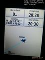
Proof. @52.1034,1.4701

Achievements
Sourcerer earned the OpenStreetMap achievement
|
Expeditions and Plans
| 2015-11-06 | ||
|---|---|---|
| Grand Rapids, Michigan | Mcbaneg | A driveway on 40th Street, Grandville, MI |
| Mannheim, Germany | Someone went | In Friedrichstal, a little bit more than 10 km north of Karlsruhe, not far ... |
| Norwich, United Kingdom | Sourcerer | In a field, off a public footpath and the Suffolk, Coastal Path, west of th... |
Sourcerer's Expedition Links
2015-11-05 52 1 - 2015-11-06 52 1 - 2015-11-07 52 1 - KML file download of Sourcerer's expeditions for use with Google Earth.