Difference between revisions of "2015-11-07 47 9"
imported>Lysogeny (+Expedition report) |
imported>Lysogeny (Done. +img +achievements +stuff) |
||
| Line 42: | Line 42: | ||
After the short trip across the <s>river</s> lake I drove through several | After the short trip across the <s>river</s> lake I drove through several | ||
smaller villages with my most interesting encounters in these being cows. | smaller villages with my most interesting encounters in these being cows. | ||
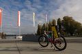
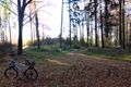
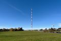
| + | [[File:2015-11-07_47_9_01_lq.jpg|200px|thumb|left|Switzerland!]] | ||
At some point something I had not earlier noticed came across my path: The hash | At some point something I had not earlier noticed came across my path: The hash | ||
| Line 48: | Line 49: | ||
and bag combination was not helping. | and bag combination was not helping. | ||
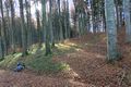
After shortly checking out Höchsten and the view here I got to the forest that has the hash. I had marked the loop in which the hash is on a map, but used my phone to find the exact location as my map was not really accurate enough. | After shortly checking out Höchsten and the view here I got to the forest that has the hash. I had marked the loop in which the hash is on a map, but used my phone to find the exact location as my map was not really accurate enough. | ||
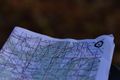
| + | [[File:2015-11-07_47_9_14_lq.jpg|200px|thumb|right|Proof]] | ||
Looking for a place to eat I went back to Höchsten and had a picnic on a field. Some dogs were digging a hole or something in said field. | Looking for a place to eat I went back to Höchsten and had a picnic on a field. Some dogs were digging a hole or something in said field. | ||
| Line 64: | Line 66: | ||
additionally the speeds I was going at might have propelled it | additionally the speeds I was going at might have propelled it | ||
who-knows-where). | who-knows-where). | ||
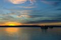
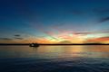
| + | [[File:2015-11-07_47_9_24_lq.jpg|200px|thumb|left|Sunset that looks like CGI]] | ||
At least on the route back the sunset allowed for some pretty nice views in | At least on the route back the sunset allowed for some pretty nice views in | ||
Meersburg. (The probably most impressive sunset that I can remember ever seeing. For the entirety of the 15 minute ferry trip I was in awe and amazement.) | Meersburg. (The probably most impressive sunset that I can remember ever seeing. For the entirety of the 15 minute ferry trip I was in awe and amazement.) | ||
| + | |||
| + | I still have some other pictures, but I have to stitch those together. They'll be here soon. | ||
== Tracklog == | == Tracklog == | ||
<!-- if your GPS device keeps a log, you may post a link here --> | <!-- if your GPS device keeps a log, you may post a link here --> | ||
| + | No tracklog as I did not have a GPS device that does this. | ||
== Photos == | == Photos == | ||
| Line 76: | Line 82: | ||
--> | --> | ||
<gallery perrow="5"> | <gallery perrow="5"> | ||
| + | Image:2015-11-07_47_9_01_lq.jpg | Same place as last week, only earlier. | ||
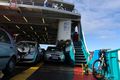
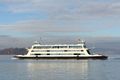
| + | Image:2015-11-07_47_9_02_lq.jpg | A ferry. | ||
| + | Image:2015-11-07_47_9_03_lq.jpg | A different ferry. | ||
| + | Image:2015-11-07_47_9_04_lq.jpg | Meersburg. They have wine. | ||
| + | Image:2015-11-07_47_9_05_lq.jpg | Cows. | ||
| + | Image:2015-11-07_47_9_07_lq.jpg | Bike after part of hill. | ||
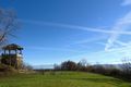
| + | Image:2015-11-07_47_9_08_lq.jpg | Whatever Höchst is, I wanna go check it out. | ||
| + | Image:2015-11-07_47_9_09_lq.jpg | A Restaurant? Is that all? | ||
| + | Image:2015-11-07_47_9_11_lq.jpg | The target loop and my bike. | ||
| + | Image:2015-11-07_47_9_12_lq.jpg | dash dash dash marks the spot. | ||
| + | Image:2015-11-07_47_9_13_lq.jpg | OSM proof. | ||
| + | Image:2015-11-07_47_9_14_lq.jpg | <i>The App</i> proof. | ||
| + | Image:2015-11-07_47_9_15_lq.jpg | The hash. Look! Some <i>Galium</i> grows there. | ||
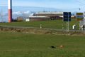
| + | Image:2015-11-07_47_9_16_lq.jpg | The hash is somewhere on this image. | ||
| + | Image:2015-11-07_47_9_17_lq.jpg | That tower probably serves no more purpose. | ||
| + | Image:2015-11-07_47_9_18_lq.jpg | They have a hut thingy on Höchst. | ||
| + | Image:2015-11-07_47_9_19_lq.jpg | They really dig that earth. | ||
| + | Image:2015-11-07_47_9_20_lq.jpg | Sheep. | ||
| + | Image:2015-11-07_47_9_21_lq.jpg | Sheep Comment. | ||
| + | Image:2015-11-07_47_9_22_lq.jpg | Sunset the first. | ||
| + | Image:2015-11-07_47_9_23_lq.jpg | Sunset the second. | ||
| + | Image:2015-11-07_47_9_24_lq.jpg | Sunset the third. | ||
</gallery> | </gallery> | ||
== Achievements == | == Achievements == | ||
{{#vardefine:ribbonwidth|800px}} | {{#vardefine:ribbonwidth|800px}} | ||
| − | <!-- Add any achievement ribbons you earned below, or remove this section | + | <!-- Add any achievement ribbons you earned below, or remove this section |
| − | |||
| − | |||
| − | |||
| − | |||
| − | |||
| − | |||
| − | |||
| − | |||
--> | --> | ||
| + | {{land geohash | latitude = 47 | longitude = 9 | date = 2015-11-07 | name = Lysogeny }} | ||
| + | {{Border geohash achievement | latitude = 47 | longitude = 9 | date = 2015-11-07 | country1= Switzerland | country2= Germany | name = Lysogeny }} | ||
| − | |||
| − | |||
| − | |||
[[Category:Expeditions]] | [[Category:Expeditions]] | ||
| − | |||
[[Category:Expeditions with photos]] | [[Category:Expeditions with photos]] | ||
| − | |||
| − | |||
| − | |||
| − | |||
| − | |||
[[Category:Coordinates reached]] | [[Category:Coordinates reached]] | ||
| − | |||
| − | |||
| − | |||
| − | |||
| − | |||
| − | |||
| − | |||
| − | |||
| − | |||
| − | |||
| − | |||
| − | |||
| − | |||
| − | |||
| − | |||
| − | |||
| − | |||
| − | |||
Revision as of 18:27, 8 November 2015
| Sat 7 Nov 2015 in 47,9: 47.8409249, 9.4207014 geohashing.info google osm bing/os kml crox |
Location
A forest by Wilhelmsdorf, Germany.
According to Swiss confederate maps the hash is located on (or close to) a track, it is however not visible in satellite imagery. Google is aware of the track as it routes through it.
Participants
Plans
Like my last expedition I intend to take the ferry to Meersburg and bike the rest of the way. Since this is a hash that is not so obviously findable I will be using my phone once I reach the forest that contains the hash. For the rest of the way I am currently printing out maps.
The entire trip should be shorter than my first hash. I also intend to leave earlier (in the morning this time) so I will not have to drive back in darkness.
Expedition
I started out my trip at around 10 in the morning. After learning from my last expedition that messenger bags are not the best for longer distances I opted to go with a bike rack and a bag for that.
On the ferry I noticed how much better the weather was this time.
After the short trip across the river lake I drove through several
smaller villages with my most interesting encounters in these being cows.

At some point something I had not earlier noticed came across my path: The hash was on a hill (or somewhere at the hill), resulting in an exhausted hasher and some pretty nice views. The additional weight brought on by the heavier rack and bag combination was not helping. After shortly checking out Höchsten and the view here I got to the forest that has the hash. I had marked the loop in which the hash is on a map, but used my phone to find the exact location as my map was not really accurate enough.

Looking for a place to eat I went back to Höchsten and had a picnic on a field. Some dogs were digging a hole or something in said field. I then tried to figure out what the tower does (Radio? TV? Both?), but apparently it is a construction site (I don't believe them).
Unfortunately as the route back was the same as the way up the hill, I did some average speed of 60km/h on the 16% incline I had rode up. Thanks to the rather harsh turbulences caused by this, I was whipped by my t-shirt which was happily flopping around in the breeze.
I also managed to loose my jacket. It was improperly fixed to the rack, and I did not think I would be going ludicrous speeds, so I did not think about attaching it a bit better. Sadly I noticed this loss way too late for a search-and-rescue operation (night was gonna fall, the distance I might have lost it on was rather great, and additionally the speeds I was going at might have propelled it who-knows-where).

At least on the route back the sunset allowed for some pretty nice views in Meersburg. (The probably most impressive sunset that I can remember ever seeing. For the entirety of the 15 minute ferry trip I was in awe and amazement.)
I still have some other pictures, but I have to stitch those together. They'll be here soon.
Tracklog
No tracklog as I did not have a GPS device that does this.
Photos
Same place as last week, only earlier.
A ferry.
A different ferry.
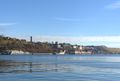
Meersburg. They have wine.
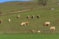
Cows.
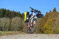
Bike after part of hill.
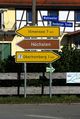
Whatever Höchst is, I wanna go check it out.
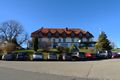
A Restaurant? Is that all?
The target loop and my bike.
dash dash dash marks the spot.

OSM proof.

The App proof.
The hash. Look! Some Galium grows there.
The hash is somewhere on this image.
That tower probably serves no more purpose.
They have a hut thingy on Höchst.
They really dig that earth.
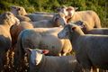
Sheep.

Sheep Comment.
Sunset the first.

Sunset the second.
Sunset the third.


Achievements
Lysogeny earned the Land geohash achievement
|
Lysogeny earned the Border geohash achievement
|