Difference between revisions of "2015-11-08 46 19"
imported>Codae (Created page with "{{subst:Expedition |lat = 46 |lon = 19 |date = 2015-11-08 }}") |
m (per Renaming Proposal) |
||
| (2 intermediate revisions by 2 users not shown) | |||
| Line 20: | Line 20: | ||
== Location == | == Location == | ||
<!-- where you've surveyed the hash to be --> | <!-- where you've surveyed the hash to be --> | ||
| + | In a field in rural Hungary, closer to Szabadszállás than anywhere else of significance. | ||
== Participants == | == Participants == | ||
<!-- who attended: If you link to your wiki user name in this section, your expedition will be picked up by the various statistics generated for geohashing. You may use three tildes ~ as a shortcut to automatically insert the user signature of the account you are editing with. | <!-- who attended: If you link to your wiki user name in this section, your expedition will be picked up by the various statistics generated for geohashing. You may use three tildes ~ as a shortcut to automatically insert the user signature of the account you are editing with. | ||
--> | --> | ||
| + | [[User:Codae|Codae]] | ||
== Plans == | == Plans == | ||
<!-- what were the original plans --> | <!-- what were the original plans --> | ||
| + | Take the train from the city out to the nearest station, walk from there a few miles to the hashpoint, then reverse. I bought train tickets the night before. | ||
== Expedition == | == Expedition == | ||
<!-- how it all turned out. your narrative goes here. --> | <!-- how it all turned out. your narrative goes here. --> | ||
| + | The Kelebia train left Keleti station at 8:05. I made it there in time, despite a few moments of panic along the way when dealing with the less-comprehensive-than-usual Sunday public transit system, bearing the gyros I'd picked up for breakfast, which ended up being fairly disappointing. The trip out was slightly complicated by my inexperience traveling alone on a train system in a country where I barely speak the language, but nothing happened that graduated from a glitch to an actual problem. | ||
| + | |||
| + | Eventually, I made it to the station on the outskirts of the hamlet of Bösztör. I'm not sure why the train stops there. Sure, it provides car-free access to the rest of the world for the dozen or so houses that constitute the village, but the region that's significantly closer to the Bösztör station than to any other (about three miles along the track in each direction) doesn't seem to have anything else in it besides private farms and a single church. Maybe my intuition about the costs and benefits of routinely stopping a train is out of whack. Regardless, that three-mile radius does include the geohash, so the existence of the Bösztör stop was critical to my undertaking this expedition. | ||
| + | |||
| + | The route from the station to the geohash was muddy, understandably, as it had rained the previous day and was still foggy when I started the trek. It was also deserted by anyone more significant than some large brown birds with a high-pitched, throaty call. I didn't recognize them, but they looked like attractive hunting targets, so I suppose they could be pheasants. Most of the fields were fallow (we have already had frost in Budapest), so I had a better sense of my isolation than when among, say, California orchards. I was impressed. | ||
| + | |||
| + | The geohash was in a field, not on one of the tracks among them. The satellite imagery gave a different division of the plots than existed in actuality, so I couldn't be sure whether the point was in an irrigated field with plants still growing in it (I'm not sure what kind; maybe carrots, but I wouldn't expect those to be so bushy) or in the neighboring plowed field with a few green shoots in it (which could have been volunteer grass, but I didn't want to risk trampling fragile crops). Wandering around the edge didn't resolve the question. Then I thought that maybe the hashpoint was right on the boundary, which would really be lucky for me: by traversing the boundary, I wouldn't have to find footing among the bushy plants and the furrows between them, and I would avoid the new growth too. | ||
| + | |||
| + | So that's what I did, and I got pretty close. The geohash turned out to be slightly within the plowed field; even though I didn't walk out to its exact location, I'm counting this as a success. | ||
| + | |||
| + | I returned to the station, witnessing an impressive north-south cloud disparity and a bunch of chickens, and waited outside for the train back north. I would have waited inside, but when I opened the door I walked into what seemed to amount to the stationmaster's office, so I made a non-excuse excuse and backed out. I caught the train and made it to Budapest without incident. | ||
== Tracklog == | == Tracklog == | ||
| Line 39: | Line 53: | ||
--> | --> | ||
<gallery perrow="5"> | <gallery perrow="5"> | ||
| + | Image:2015-11-08 46 19 Proof.JPG | Standing on the boundary between the plots. | ||
| + | Image:2015-11-08 46 19 Field.JPG | To the east, crops... | ||
| + | Image:2015-11-08 46 19 Farmhouse.JPG | ...to the west, an empty field, then a road, then the nearest structure. | ||
</gallery> | </gallery> | ||
| Line 44: | Line 61: | ||
{{#vardefine:ribbonwidth|800px}} | {{#vardefine:ribbonwidth|800px}} | ||
<!-- Add any achievement ribbons you earned below, or remove this section --> | <!-- Add any achievement ribbons you earned below, or remove this section --> | ||
| + | {{Land geohash|latitude=46|longitude=19|date=2015-11-08|name=Codae}} | ||
| + | {{Minesweeper geohash|graticule=Budapest, Hungary|ranknumber=1|s=true|name=Codae}} | ||
| + | {{Graticule unlocked|latitude=46|longitude=19|date=2015-11-08|name=Codae}} | ||
<!-- =============== USEFUL CATEGORIES FOLLOW ================ | <!-- =============== USEFUL CATEGORIES FOLLOW ================ | ||
Delete the next line ONLY if you have chosen the appropriate categories below. If you are unsure, don't worry. People will read your report and help you with the classification. --> | Delete the next line ONLY if you have chosen the appropriate categories below. If you are unsure, don't worry. People will read your report and help you with the classification. --> | ||
| − | + | ||
<!-- Potential categories. Please include all the ones appropriate to your expedition --> | <!-- Potential categories. Please include all the ones appropriate to your expedition --> | ||
| − | |||
| − | |||
| − | |||
| − | + | [[Category:Expeditions]] | |
| − | |||
| − | |||
| − | |||
[[Category:Expeditions with photos]] | [[Category:Expeditions with photos]] | ||
| − | + | ||
| − | |||
| − | |||
| − | |||
| − | |||
[[Category:Coordinates reached]] | [[Category:Coordinates reached]] | ||
| − | + | {{location|HU|BK}} | |
| − | |||
| − | |||
| − | |||
| − | |||
| − | |||
| − | |||
| − | |||
| − | |||
| − | |||
| − | |||
| − | |||
| − | |||
| − | |||
| − | |||
| − | |||
| − | |||
| − | |||
Latest revision as of 05:02, 20 March 2024
| Sun 8 Nov 2015 in 46,19: 46.9053471, 19.1586973 geohashing.info google osm bing/os kml crox |
Location
In a field in rural Hungary, closer to Szabadszállás than anywhere else of significance.
Participants
Plans
Take the train from the city out to the nearest station, walk from there a few miles to the hashpoint, then reverse. I bought train tickets the night before.
Expedition
The Kelebia train left Keleti station at 8:05. I made it there in time, despite a few moments of panic along the way when dealing with the less-comprehensive-than-usual Sunday public transit system, bearing the gyros I'd picked up for breakfast, which ended up being fairly disappointing. The trip out was slightly complicated by my inexperience traveling alone on a train system in a country where I barely speak the language, but nothing happened that graduated from a glitch to an actual problem.
Eventually, I made it to the station on the outskirts of the hamlet of Bösztör. I'm not sure why the train stops there. Sure, it provides car-free access to the rest of the world for the dozen or so houses that constitute the village, but the region that's significantly closer to the Bösztör station than to any other (about three miles along the track in each direction) doesn't seem to have anything else in it besides private farms and a single church. Maybe my intuition about the costs and benefits of routinely stopping a train is out of whack. Regardless, that three-mile radius does include the geohash, so the existence of the Bösztör stop was critical to my undertaking this expedition.
The route from the station to the geohash was muddy, understandably, as it had rained the previous day and was still foggy when I started the trek. It was also deserted by anyone more significant than some large brown birds with a high-pitched, throaty call. I didn't recognize them, but they looked like attractive hunting targets, so I suppose they could be pheasants. Most of the fields were fallow (we have already had frost in Budapest), so I had a better sense of my isolation than when among, say, California orchards. I was impressed.
The geohash was in a field, not on one of the tracks among them. The satellite imagery gave a different division of the plots than existed in actuality, so I couldn't be sure whether the point was in an irrigated field with plants still growing in it (I'm not sure what kind; maybe carrots, but I wouldn't expect those to be so bushy) or in the neighboring plowed field with a few green shoots in it (which could have been volunteer grass, but I didn't want to risk trampling fragile crops). Wandering around the edge didn't resolve the question. Then I thought that maybe the hashpoint was right on the boundary, which would really be lucky for me: by traversing the boundary, I wouldn't have to find footing among the bushy plants and the furrows between them, and I would avoid the new growth too.
So that's what I did, and I got pretty close. The geohash turned out to be slightly within the plowed field; even though I didn't walk out to its exact location, I'm counting this as a success.
I returned to the station, witnessing an impressive north-south cloud disparity and a bunch of chickens, and waited outside for the train back north. I would have waited inside, but when I opened the door I walked into what seemed to amount to the stationmaster's office, so I made a non-excuse excuse and backed out. I caught the train and made it to Budapest without incident.
Tracklog
Photos
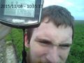
Standing on the boundary between the plots.
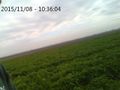
To the east, crops...
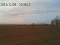
...to the west, an empty field, then a road, then the nearest structure.


Achievements
Codae earned the Land geohash achievement
|
Codae achieved level 1 of the Minesweeper Geohash achievement
|
Codae earned the Graticule Unlocked Achievement
|