Difference between revisions of "2015-11-10 47 -117"
From Geohashing
imported>Thomcat (double expedition #2) |
imported>FippeBot m (Location) |
||
| (One intermediate revision by one other user not shown) | |||
| Line 27: | Line 27: | ||
--> | --> | ||
<gallery perrow="5"> | <gallery perrow="5"> | ||
| − | + | Image:2015-11-10_47_-117_Screencap.jpg | Parked on the spot | |
| + | Image:2015-11-10_47_-117_CarNav.jpg | ||
| + | Image:2015-11-10_47_-117_Geohasher.jpg | ||
</gallery> | </gallery> | ||
| Line 37: | Line 39: | ||
[[Category:Expeditions with photos]] | [[Category:Expeditions with photos]] | ||
[[Category:Coordinates reached]] | [[Category:Coordinates reached]] | ||
| + | {{location|US|WA|SP}} | ||
Latest revision as of 05:46, 15 August 2019
| Tue 10 Nov 2015 in Spokane: 47.6511490, -117.1405681 geohashing.info google osm bing/os kml crox |
Location
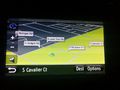
On Cavalier Court, a cul-de-sac in eastern Spokane Valley.
Participants
Expedition
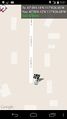
This hashpoint is on the road surface, so I know I can visit anytime. Arriving in town, I rushed from appointment to appointment, finally free early in the evening. I set my geohash car nav to the site and drove on.
Cavalier Court was very residential and very dark. I parked on the hashpoint and snapped a self picture, then tried a few shots outside. If any turned out, I'll upload them below.
Tracklog
Photos
Parked on the spot