Difference between revisions of "2015-11-11 47 9"
imported>Lysogeny (Plans, people.) |
imported>FippeBot m (Location) |
||
| (6 intermediate revisions by one other user not shown) | |||
| Line 1: | Line 1: | ||
| − | + | [[Image:2015-11-11_47_9_06.jpg|thumb|left]] | |
| − | |||
| − | |||
| − | [[Image: | ||
| − | |||
| − | |||
| − | |||
| − | |||
| − | |||
| − | |||
{{meetup graticule | {{meetup graticule | ||
| lat=47 | | lat=47 | ||
| Line 15: | Line 6: | ||
}} | }} | ||
| − | |||
__NOTOC__ | __NOTOC__ | ||
== Location == | == Location == | ||
| − | |||
In a bush by a ditch in Konstanz, Germany. | In a bush by a ditch in Konstanz, Germany. | ||
== Participants == | == Participants == | ||
| − | + | ||
| − | |||
[[User:Lysogeny|Lysogeny]] ([[User talk:Lysogeny|talk]]) | [[User:Lysogeny|Lysogeny]] ([[User talk:Lysogeny|talk]]) | ||
== Plans == | == Plans == | ||
| − | |||
This is not that far from where I live and do things, which means that I will probably go there by bike after noon. ETA: ~13:00 local time (UTC+1) | This is not that far from where I live and do things, which means that I will probably go there by bike after noon. ETA: ~13:00 local time (UTC+1) | ||
== Expedition == | == Expedition == | ||
| − | + | I left for the university in the early morning fog. | |
| + | After my first course here I got distracted by the printer show-case they have to let people voice their opinion on which printer system to get for the university. | ||
| + | As a result I did not get to the hash by the time I originally intended. | ||
| + | |||
| + | The route to the hash was rather short, (~3km). | ||
| + | I started at the biology department, and then went through the forest to Wollmatingen. | ||
| + | After entering the district I turned into a small pedestrian dirt road. | ||
| + | My route took me over a surprisingly well-maintaned bridge, and then into the bushes. | ||
| + | These bushes are the type of place I would expect a dead body or something, lot's of litter in and around them. | ||
| + | |||
| + | Anyhow, after crossing a small dried-up brook (which I swear was on the other side of the hash in google maps. Either my phone's GPS was being silly, or google is just wrong about that brook), I reached the hash, found nothing worthwhile, left from the bushes out of fear of my bike being stolen and went back to university. | ||
| + | |||
| + | After what appeared like ages of grueling boredom, configuring apache, and designing a shitty icon, I had my second (and final) lecture of the day and went back home through the fresh fog that had formed due to the sunset. | ||
| + | |||
| + | Estimated trip distance (Uni → Hash): 3km | ||
== Tracklog == | == Tracklog == | ||
<!-- if your GPS device keeps a log, you may post a link here --> | <!-- if your GPS device keeps a log, you may post a link here --> | ||
| + | I tried to get my phone to keep a tracklog with an app I found. | ||
| + | It has one point every 15s, so it is rather low resolution. | ||
| + | I just looked at it, and it is not really worthwhile. Really bad. But here you go non-theless: | ||
| + | [http://i.jooa.xyz/20151111.kml] | ||
== Photos == | == Photos == | ||
| − | |||
| − | |||
| − | |||
<gallery perrow="5"> | <gallery perrow="5"> | ||
| + | Image:2015-11-11_47_9_01.jpg|Biology Department. | ||
| + | Image:2015-11-11_47_9_02.jpg|dirt road. | ||
| + | Image:2015-11-11_47_9_03.jpg|Surprisingly well-maintained. | ||
| + | Image:2015-11-11_47_9_04.jpg|And with absolutely no point at the moment. | ||
| + | Image:2015-11-11_47_9_05.jpg|Somewhere in this bush. | ||
| + | Image:2015-11-11_47_9_06.jpg|Found it! | ||
| + | Image:2015-11-11_47_9_07.jpg|That is it. | ||
| + | Image:2015-11-11_47_9_08.jpg|Evening fog. | ||
| + | Image:2015-11-11_47_9_09.png|Proof0 | ||
| + | Image:2015-11-11_47_9_10.png|Proof1 | ||
</gallery> | </gallery> | ||
| Line 47: | Line 59: | ||
{{#vardefine:ribbonwidth|800px}} | {{#vardefine:ribbonwidth|800px}} | ||
<!-- Add any achievement ribbons you earned below, or remove this section --> | <!-- Add any achievement ribbons you earned below, or remove this section --> | ||
| + | {{land geohash | latitude = 47 | longitude = 9 | date = 2015-11-11 | name = Lysogeny }} | ||
| + | {{bicycle geohash | latitude = 47 | longitude = 9 | date = 2015-11-11 | distance=3km | name = Lysogeny }} | ||
| − | |||
| − | |||
| − | |||
| − | |||
| − | |||
| − | |||
| − | |||
| − | |||
| − | |||
| − | |||
| − | |||
| − | |||
[[Category:Expeditions]] | [[Category:Expeditions]] | ||
| − | |||
[[Category:Expeditions with photos]] | [[Category:Expeditions with photos]] | ||
| − | |||
| − | |||
| − | |||
| − | |||
| − | |||
[[Category:Coordinates reached]] | [[Category:Coordinates reached]] | ||
| − | + | {{location|DE|BW|KN}} | |
| − | |||
| − | |||
| − | |||
| − | |||
| − | |||
| − | |||
| − | |||
| − | |||
| − | |||
| − | |||
| − | |||
| − | |||
| − | |||
| − | |||
| − | |||
| − | |||
| − | |||
Latest revision as of 05:47, 15 August 2019

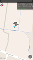
| Wed 11 Nov 2015 in 47,9: 47.6894432, 9.1561064 geohashing.info google osm bing/os kml crox |
Location
In a bush by a ditch in Konstanz, Germany.
Participants
Plans
This is not that far from where I live and do things, which means that I will probably go there by bike after noon. ETA: ~13:00 local time (UTC+1)
Expedition
I left for the university in the early morning fog. After my first course here I got distracted by the printer show-case they have to let people voice their opinion on which printer system to get for the university. As a result I did not get to the hash by the time I originally intended.
The route to the hash was rather short, (~3km). I started at the biology department, and then went through the forest to Wollmatingen. After entering the district I turned into a small pedestrian dirt road. My route took me over a surprisingly well-maintaned bridge, and then into the bushes. These bushes are the type of place I would expect a dead body or something, lot's of litter in and around them.
Anyhow, after crossing a small dried-up brook (which I swear was on the other side of the hash in google maps. Either my phone's GPS was being silly, or google is just wrong about that brook), I reached the hash, found nothing worthwhile, left from the bushes out of fear of my bike being stolen and went back to university.
After what appeared like ages of grueling boredom, configuring apache, and designing a shitty icon, I had my second (and final) lecture of the day and went back home through the fresh fog that had formed due to the sunset.
Estimated trip distance (Uni → Hash): 3km
Tracklog
I tried to get my phone to keep a tracklog with an app I found. It has one point every 15s, so it is rather low resolution. I just looked at it, and it is not really worthwhile. Really bad. But here you go non-theless: [1]
Photos
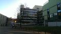
Biology Department.

dirt road.
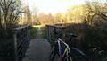
Surprisingly well-maintained.
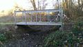
And with absolutely no point at the moment.
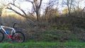
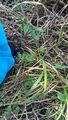
Somewhere in this bush.
Found it!
That is it.
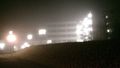
Evening fog.
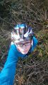
Proof0
Proof1


Achievements
Lysogeny earned the Land geohash achievement
|
Lysogeny earned the Bicycle geohash achievement
|