Difference between revisions of "2015-11-15 47 -122"
imported>Zebburkeconte (Created page with "{{subst:Expedition |lat = 47 |lon = -122 |date = 2015-11-15 }}") |
imported>FippeBot m (Location) |
||
| (8 intermediate revisions by one other user not shown) | |||
| Line 19: | Line 19: | ||
== Location == | == Location == | ||
| − | + | Slightly off a gravel road on a farm near Poulsbo. | |
== Participants == | == Participants == | ||
| − | + | [[User:Zebburkeconte|zebburkeconte]] | |
| − | + | ||
| + | zebburkeconte's friends Dillon and Liz | ||
== Plans == | == Plans == | ||
| − | + | Walk (mostly). We knew we had to take a ferry, but wanted to stick to walking besides that. | |
== Expedition == | == Expedition == | ||
| − | + | We set off for the ferry at about 6:45 AM from Capitol Hill, and caught the 7:55 ferry to Bainbridge. We stopped at McDonald's for some very nutritious food, and then began the walk. It was around 14 miles from the ferry terminal on Bainbridge, mostly on the shoulder of the highway. It wasn't exactly a popular route with pedestrians, and some people in passing cars stared at us, or even pointed. I found a copy of The Bourne Ultimatum on DVD on the side of the highway. Interested to see whether it still works. | |
| + | |||
| + | Luckily for us, the bridge we had to cross leaving Bainbridge had a sidewalk (I had checked in Street View beforehand), but that sidewalk was pretty narrow and I'm not the best with heights either. We made it across, though, which is all that matters. We briefly ran as we were entering Poulsbo, but quickly realized that was not a good idea. | ||
| − | + | We still hadn't turned in the first 12 or so miles of walking, staying on 305 the whole time. When we finally came to the first real direction in Google Maps, to turn right on Bond St, we knew we were almost there (and also finally free of the references to Bond, James). | |
| − | + | ||
| + | The farm the geohash was located on was very quaint--they even had a chalkboard-style sign at the entrance announcing a marriage ("It's a hitchin!"). They also had some very nice llamas. | ||
| + | |||
| + | We followed a gravel road past the farm and reached the hashpoint, just a few feet off the gravel. Expedition success! | ||
| + | |||
| + | My dad very kindly provided motorized backup, and gave us a ride home. | ||
== Photos == | == Photos == | ||
| Line 39: | Line 47: | ||
--> | --> | ||
<gallery perrow="5"> | <gallery perrow="5"> | ||
| + | Image:2015-11-15 47 -122 1.jpeg | Liz's prophetic llama impression | ||
| + | Image:2015-11-15 47 -122 2.jpeg | We start walking! | ||
| + | Image:2015-11-15 47 -122 3.jpeg | How not to use a bench | ||
| + | Image:2015-11-15 47 -122 4.jpeg | More walking. A ''lot'' more | ||
| + | Image:2015-11-15 47 -122 5.jpeg | Whoever threw this away doesn't know how to appreciate a great movie | ||
| + | Image:2015-11-15 47 -122 6.jpeg | A bridge! | ||
| + | Image:2015-11-15 47 -122 7.jpeg | The llamas | ||
| + | Image:2015-11-15 47 -122 8.jpeg | Us, at the geohash | ||
| + | Image:2015-11-15 47 -122 9.jpeg | GPS was a little finicky, we definitely were on it though | ||
</gallery> | </gallery> | ||
| Line 44: | Line 61: | ||
{{#vardefine:ribbonwidth|800px}} | {{#vardefine:ribbonwidth|800px}} | ||
<!-- Add any achievement ribbons you earned below, or remove this section --> | <!-- Add any achievement ribbons you earned below, or remove this section --> | ||
| + | {{land geohash | ||
| + | | latitude = 47 | ||
| + | | longitude = -122 | ||
| + | | date = 2015-11-15 | ||
| + | | name = [[User:Zebburkeconte|Zebburkeconte]] and friends Dillon and Liz | ||
| + | }} | ||
| − | + | {{drag-along | |
| − | + | | latitude = 47 | |
| − | + | | longitude = -122 | |
| − | + | | date = 2015-11-15 | |
| − | + | | partner = Liz, and especially Dillon | |
| − | + | | name = [[User:Zebburkeconte|Zebburkeconte]] | |
| − | [[ | + | }} |
| − | |||
| − | |||
| − | |||
| − | |||
[[Category:Expeditions]] | [[Category:Expeditions]] | ||
| − | + | [[Category:Expeditions with photos]] | |
| − | [[Category:Expeditions with photos]] | ||
| − | |||
| − | |||
| − | |||
| − | |||
| − | |||
[[Category:Coordinates reached]] | [[Category:Coordinates reached]] | ||
| − | + | {{location|US|WA|KS}} | |
| − | |||
| − | |||
| − | |||
| − | |||
| − | |||
| − | |||
| − | |||
| − | |||
| − | |||
| − | |||
| − | |||
| − | |||
| − | |||
| − | |||
| − | |||
| − | |||
| − | |||
Latest revision as of 05:50, 15 August 2019
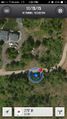
| Sun 15 Nov 2015 in 47,-122: 47.7606843, -122.6327538 geohashing.info google osm bing/os kml crox |
Location
Slightly off a gravel road on a farm near Poulsbo.
Participants
zebburkeconte's friends Dillon and Liz
Plans
Walk (mostly). We knew we had to take a ferry, but wanted to stick to walking besides that.
Expedition
We set off for the ferry at about 6:45 AM from Capitol Hill, and caught the 7:55 ferry to Bainbridge. We stopped at McDonald's for some very nutritious food, and then began the walk. It was around 14 miles from the ferry terminal on Bainbridge, mostly on the shoulder of the highway. It wasn't exactly a popular route with pedestrians, and some people in passing cars stared at us, or even pointed. I found a copy of The Bourne Ultimatum on DVD on the side of the highway. Interested to see whether it still works.
Luckily for us, the bridge we had to cross leaving Bainbridge had a sidewalk (I had checked in Street View beforehand), but that sidewalk was pretty narrow and I'm not the best with heights either. We made it across, though, which is all that matters. We briefly ran as we were entering Poulsbo, but quickly realized that was not a good idea.
We still hadn't turned in the first 12 or so miles of walking, staying on 305 the whole time. When we finally came to the first real direction in Google Maps, to turn right on Bond St, we knew we were almost there (and also finally free of the references to Bond, James).
The farm the geohash was located on was very quaint--they even had a chalkboard-style sign at the entrance announcing a marriage ("It's a hitchin!"). They also had some very nice llamas.
We followed a gravel road past the farm and reached the hashpoint, just a few feet off the gravel. Expedition success!
My dad very kindly provided motorized backup, and gave us a ride home.
Photos
Liz's prophetic llama impression
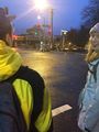
We start walking!
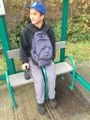
How not to use a bench
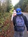
More walking. A lot more
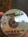
Whoever threw this away doesn't know how to appreciate a great movie
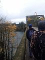
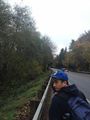
A bridge!
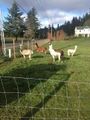
The llamas
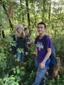
Us, at the geohash
GPS was a little finicky, we definitely were on it though


Achievements
Zebburkeconte and friends Dillon and Liz earned the Land geohash achievement
|
Zebburkeconte earned the Drag-along achievement
|