Difference between revisions of "2015-11-24 -12 130"
imported>Felix Dance ([live picture]Sunset in Palmerston [http://www.openstreetmap.org/?lat=-12.48020150&lon=130.97486770&zoom=16&layers=B000FTF @-12.4802,130.9749]) |
m |
||
| (8 intermediate revisions by 4 users not shown) | |||
| Line 1: | Line 1: | ||
| + | [[Image:{{{image|2015-11-24_-12_130_Felix Dance_1448357337521.jpg}}}|thumb|150px|left]] | ||
| − | |||
| − | |||
| − | |||
| − | |||
| − | |||
| − | |||
| − | |||
| − | |||
| − | |||
{{meetup graticule | {{meetup graticule | ||
| lat=-12 | | lat=-12 | ||
| Line 19: | Line 11: | ||
== Location == | == Location == | ||
| − | + | On University Avenue, next to the Palmerston Golf Course | |
== Participants == | == Participants == | ||
| + | *[[User:Felix Dance|Felix Dance]] | ||
<!-- who attended: If you link to your wiki user name in this section, your expedition will be picked up by the various statistics generated for geohashing. You may use three tildes ~ as a shortcut to automatically insert the user signature of the account you are editing with. | <!-- who attended: If you link to your wiki user name in this section, your expedition will be picked up by the various statistics generated for geohashing. You may use three tildes ~ as a shortcut to automatically insert the user signature of the account you are editing with. | ||
--> | --> | ||
| − | == | + | == Expedition == |
| − | + | I've been riding to work recently - or, more exactly, riding from Darwin, where I live, to Palmerston, where I don't live, nor work, but where I occasionally take the bus to the construction site at which I spend a sizable chunk of my waking life. | |
| + | |||
| + | However, today I decided to enjoy the sleep-in and take the bus from town. This proved to be an annoying mistake, as, upon arriving at work, I discovered the geohash for that day to be very close to where I would have parked my bike in Palmerston. Knowing I couldn't walk away from such a hash, so to speak, I took the bus back to Darwin at the end of the day, rode my bike home, changed, and rode a different bike back out to Palmerston an hour away. | ||
| − | + | Riding 50% faster than my usual commute speed through a combination of not having panniers, riding a lighter road bike and being somewhat freer of the draining existential exhaustion often experienced during work commutes, I quickly descended upon the hash-locale, the sun setting on me as though spiting my endeavour in pique. | |
| − | + | ||
| + | Spending a seemingly interminable period friggin' around with the newly updated hash-app and associated mechana to suck my camera's photos through the wifi onto my phone, have them rotated, appended with coordinates, described and installed onto the self-creating wiki page, all the while being consumed by a golf-course swamp's worth of mosquito feeding-frenzy denizens, I had achieved the broad aims of my expedition and mounted my steel steed to bring myself home - pausing only briefly to resupply bodily energy stocks with a kebab and sarsaparilla from a charming Berrimer-based eatery. Otherwise, the ride was uneventful. | ||
| − | + | [https://goo.gl/maps/aNP8Jb1SAMz Here] is the route of my trip. | |
| − | |||
== Photos == | == Photos == | ||
| Line 43: | Line 38: | ||
Image:2015-11-24_-12_130_Felix Dance_1448357381384.jpg|Sunset in Palmerston [http://www.openstreetmap.org/?lat=-12.48020150&lon=130.97486770&zoom=16&layers=B000FTF @-12.4802,130.9749] | Image:2015-11-24_-12_130_Felix Dance_1448357381384.jpg|Sunset in Palmerston [http://www.openstreetmap.org/?lat=-12.48020150&lon=130.97486770&zoom=16&layers=B000FTF @-12.4802,130.9749] | ||
| − | |||
| − | == | + | Image:2015-11-24_-12_130_Felix Dance_1448357558434.jpg|GPS proof [http://www.openstreetmap.org/?lat=-12.48020450&lon=130.97485990&zoom=16&layers=B000FTF @-12.4802,130.9749] |
| − | + | ||
| − | + | Image:2015-11-24_-12_130_Felix Dance_1448357578431.jpg|Felix riding to the hash [http://www.openstreetmap.org/?lat=-12.48020450&lon=130.97485960&zoom=16&layers=B000FTF @-12.4802,130.9749] | |
| − | + | Image:2015-11-24_-12_130_Felix Dance_1448357611113.jpg|Sunset scenery on the way to the hash [http://www.openstreetmap.org/?lat=-12.48020460&lon=130.97485950&zoom=16&layers=B000FTF @-12.4802,130.9749] | |
| − | |||
| − | |||
| − | + | Image:2015-11-24_-12_130_Felix Dance_1448360608269.jpg|Celebratory kebab and sarsaparilla on the ride home. [http://www.openstreetmap.org/?lat=-12.43225030&lon=130.92296400&zoom=16&layers=B000FTF @-12.4323,130.9230] | |
| − | < | + | </gallery> |
| − | |||
| − | |||
| − | + | == Achievements == | |
| + | {{bicycle geohash | ||
| + | | latitude = -12 | ||
| + | | longitude = 130 | ||
| + | | date = 2015-11-24 | ||
| + | | name = Felix Dance | ||
| + | | distance = 43 kms | ||
| + | | bothways = TRUE | ||
| + | | image = 2015-11-24_-12_130_Felix Dance_1448357578431.jpg | ||
| + | }} | ||
| − | |||
[[Category:Expeditions]] | [[Category:Expeditions]] | ||
| − | |||
[[Category:Expeditions with photos]] | [[Category:Expeditions with photos]] | ||
| − | |||
| − | |||
| − | |||
| − | |||
| − | |||
[[Category:Coordinates reached]] | [[Category:Coordinates reached]] | ||
| − | + | {{location|AU|NT|PA}} | |
| − | |||
| − | |||
| − | |||
| − | |||
| − | |||
| − | |||
| − | |||
| − | |||
| − | |||
| − | |||
| − | |||
| − | |||
| − | |||
| − | |||
| − | |||
| − | |||
| − | |||
Latest revision as of 15:31, 22 September 2021

| Tue 24 Nov 2015 in -12,130: -12.4802333, 130.9748643 geohashing.info google osm bing/os kml crox |
Location
On University Avenue, next to the Palmerston Golf Course
Participants
Expedition
I've been riding to work recently - or, more exactly, riding from Darwin, where I live, to Palmerston, where I don't live, nor work, but where I occasionally take the bus to the construction site at which I spend a sizable chunk of my waking life.
However, today I decided to enjoy the sleep-in and take the bus from town. This proved to be an annoying mistake, as, upon arriving at work, I discovered the geohash for that day to be very close to where I would have parked my bike in Palmerston. Knowing I couldn't walk away from such a hash, so to speak, I took the bus back to Darwin at the end of the day, rode my bike home, changed, and rode a different bike back out to Palmerston an hour away.
Riding 50% faster than my usual commute speed through a combination of not having panniers, riding a lighter road bike and being somewhat freer of the draining existential exhaustion often experienced during work commutes, I quickly descended upon the hash-locale, the sun setting on me as though spiting my endeavour in pique.
Spending a seemingly interminable period friggin' around with the newly updated hash-app and associated mechana to suck my camera's photos through the wifi onto my phone, have them rotated, appended with coordinates, described and installed onto the self-creating wiki page, all the while being consumed by a golf-course swamp's worth of mosquito feeding-frenzy denizens, I had achieved the broad aims of my expedition and mounted my steel steed to bring myself home - pausing only briefly to resupply bodily energy stocks with a kebab and sarsaparilla from a charming Berrimer-based eatery. Otherwise, the ride was uneventful.
Here is the route of my trip.
Photos

Straight-forward hash in Palmerston @-12.4802,130.9749
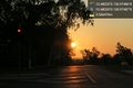
Sunset in Palmerston @-12.4802,130.9749
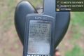
GPS proof @-12.4802,130.9749

Felix riding to the hash @-12.4802,130.9749
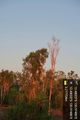
Sunset scenery on the way to the hash @-12.4802,130.9749
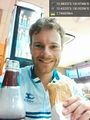
Celebratory kebab and sarsaparilla on the ride home. @-12.4323,130.9230


Achievements
Felix Dance earned the Bicycle geohash achievement
|