Difference between revisions of "2015-11-28 48 9"
imported>Ekorren (→Plans: Sorry, no.) |
imported>FippeBot m (Location) |
||
| (6 intermediate revisions by one other user not shown) | |||
| Line 1: | Line 1: | ||
| − | + | [[Image:{{{image|2015-11-28_48_9_marker_frontal.jpg}}}|thumb|left]] | |
| − | |||
| − | |||
| − | [[Image:{{{image| | ||
| − | |||
| − | |||
| − | |||
| − | |||
| − | |||
| − | |||
{{meetup graticule | {{meetup graticule | ||
| Line 22: | Line 13: | ||
== Participants == | == Participants == | ||
| − | * [[User:Klaus|Klaus]] | + | * [[User:Klaus|Klaus]], drag-along |
== Plans == | == Plans == | ||
| Line 34: | Line 25: | ||
== Expedition == | == Expedition == | ||
| − | |||
| − | + | [[User:Klaus]] and a dragalong decided to go for it. | |
| − | + | As using the bus to Waldhäuser-Ost and walking the 100m from there would have been too short, we decided not to do it like this and instead go for a Saturday-afternoon-walk. | |
| + | |||
| + | The dragalong didn't want to start from my home because of the 100 height metres, so we decided to start from the Botanic Garden in Tübingen. | ||
| + | So we walked from there, went to the hash and walked back... We were a few minutes after two at the geohash and stayed there for around 5min, the time we needed to create a biological marker. | ||
| + | |||
| + | After around one and a half hours later we arrived at the Botanic garden again and drove home. | ||
== Photos == | == Photos == | ||
| − | |||
| − | |||
| − | |||
<gallery perrow="5"> | <gallery perrow="5"> | ||
| + | Image:2015-11-28 48 9 labyrinth.jpg | Labyrinth on the schoolyard of the Waldorf-school | ||
| + | Image:2015-11-28 48 9 view from next path.jpg | somewhere down there, let's leave the path | ||
| + | Image:2015-11-28 48 9 proof.jpg | Proof | ||
| + | Image:2015-11-28 48 9 me.jpg | censored me standing at the geohash | ||
| + | Image:2015-11-28_48_9_marker_frontal.jpg | Bio-degradable Marker | ||
| + | Image:2015-11-28 48 9 marker.jpg | Marker and geohash | ||
| + | Image:2015-11-28 48 9 view from geohash1.jpg | View from Geohash #1 | ||
| + | Image:2015-11-28 48 9 view from geohash2.jpg | View from Geohash #2 | ||
| + | Image:2015-11-28 48 9 view from geohash3.jpg | View from Geohash #3 | ||
| + | Image:2015-11-28 48 9 not a marker.jpg | Found on the path near to the geohash... Obviously someone wanted to make XKCD, but stopped halfway through? ;) | ||
</gallery> | </gallery> | ||
== Achievements == | == Achievements == | ||
{{#vardefine:ribbonwidth|800px}} | {{#vardefine:ribbonwidth|800px}} | ||
| − | + | {{land geohash | |
| + | | latitude = 48 | ||
| + | | longitude = 9 | ||
| + | | date = 2015-11-28 | ||
| + | | name = [[User:Klaus|Klaus]] | ||
| + | }} | ||
| + | {{Template:Drag-along | ||
| + | | latitude = 48 | ||
| + | | longitude = 9 | ||
| + | | date = 2015-11-28 | ||
| + | | name = [[User:Klaus|Klaus]] | ||
| + | | partner = Ben | ||
| + | }} | ||
| − | |||
| − | |||
| − | |||
| − | |||
| − | |||
| − | |||
[[Category:Expeditions]] | [[Category:Expeditions]] | ||
| − | |||
[[Category:Expeditions with photos]] | [[Category:Expeditions with photos]] | ||
| − | |||
| − | |||
| − | |||
| − | |||
| − | |||
[[Category:Coordinates reached]] | [[Category:Coordinates reached]] | ||
| − | + | {{location|DE|BW|TÜ}} | |
| − | |||
| − | |||
| − | |||
| − | |||
| − | |||
| − | |||
| − | |||
| − | |||
| − | |||
| − | |||
| − | |||
| − | |||
| − | |||
| − | |||
| − | |||
| − | |||
| − | |||
Latest revision as of 05:59, 15 August 2019

| Sat 28 Nov 2015 in 48,9: 48.5481804, 9.0620925 geohashing.info google osm bing/os kml crox |
Location
in the forest behind Waldhäuser-Ost, Tübingen
Participants
- Klaus, drag-along
Plans
Klaus
November 2015 is a good month! Again a geohash very close to my home. Saturday meetup anyone? I'm flexible regarding meetup time, if noone else announces plans, I'll probably go after lunch at around 14:00.
Ekorren
Won't go. Sorry, I'm basically occupied all day. I don't think I can squeeze in the two hours I would probably need to go and visit this hash. --Ekorren (talk) 10:19, 27 November 2015 (EST)
Expedition
User:Klaus and a dragalong decided to go for it. As using the bus to Waldhäuser-Ost and walking the 100m from there would have been too short, we decided not to do it like this and instead go for a Saturday-afternoon-walk.
The dragalong didn't want to start from my home because of the 100 height metres, so we decided to start from the Botanic Garden in Tübingen. So we walked from there, went to the hash and walked back... We were a few minutes after two at the geohash and stayed there for around 5min, the time we needed to create a biological marker.
After around one and a half hours later we arrived at the Botanic garden again and drove home.
Photos
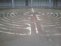
Labyrinth on the schoolyard of the Waldorf-school
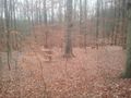
somewhere down there, let's leave the path
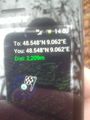
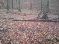
Proof
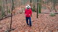
censored me standing at the geohash
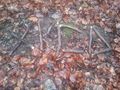
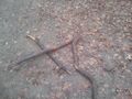
Bio-degradable Marker
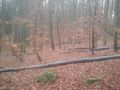
Marker and geohash
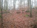
View from Geohash #1
View from Geohash #2
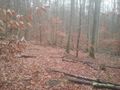
View from Geohash #3
Found on the path near to the geohash... Obviously someone wanted to make XKCD, but stopped halfway through? ;)


Achievements
Klaus earned the Land geohash achievement
|
Klaus earned the Drag-along achievement
|