Difference between revisions of "2015-12-01 48 11"
From Geohashing
imported>TheOneRing (Created page with "{{meetup graticule | lat=48 | lon=11 | date=2015-12-01 }} == Location == The geohash is on a meadow at Inning. == Who Went == *TheOneRing - by car. == T...") |
imported>FippeBot m (Location) |
||
| Line 35: | Line 35: | ||
[[Category:Expeditions with photos]] | [[Category:Expeditions with photos]] | ||
[[Category:Coordinates reached]] | [[Category:Coordinates reached]] | ||
| + | {{location|DE|BY|STA}} | ||
Latest revision as of 06:01, 15 August 2019
| Tue 1 Dec 2015 in 48,11: 48.0716955, 11.1425712 geohashing.info google osm bing/os kml crox |
Contents
Location
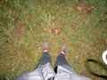
The geohash is on a meadow at Inning.
Who Went
- TheOneRing - by car.
The Expedition
TheOneRing
This one was on my way home; I only had to make a small detour. I left the office to get to the geohash right at sunset, but due to traffic I was a little late and it was dark already.
The geohash was on a meadow next to a gym. So there were enough parking lots available. The rest was a five minute walk with taking pictures.
Finally, I drove home; not quite special this time.
Photos
TheOneRing
Here it is
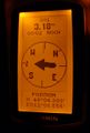
Coordinates reached
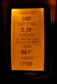
Some more information

The hasher in the dark
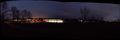
View from the geohash over the gym


Achievements
TheOneRing earned the Land geohash achievement
|