Difference between revisions of "2015-12-01 48 8"
imported>RecentlyChanged (An expedition message sent via Geohash Droid for Android.) |
imported>FippeBot m (Location) |
||
| (3 intermediate revisions by one other user not shown) | |||
| Line 19: | Line 19: | ||
== Location == | == Location == | ||
| − | + | Steep hill. | |
== Participants == | == Participants == | ||
| − | + | [[User:RecentlyChanged|RecentlyChanged]] ([[User_talk:RecentlyChanged|talk]]) | |
| − | + | and his mother | |
== Plans == | == Plans == | ||
| − | + | I wanted to walk there from school and afterwards meet my mother. | |
== Expedition == | == Expedition == | ||
| − | + | *I'm starting my mission now. By feet. I hope I will arrive in about one and hal an hour. The weather is horrible. -- [[User:RecentlyChanged|RecentlyChanged]] ([[User_talk:RecentlyChanged|talk]]) [http://www.openstreetmap.org/?lat=48.04746160&lon=8.21244150&zoom=16&layers=B000FTF @48.0475,8.2124] 11:36, 1 December 2015 (CET) | |
| + | |||
| + | Ok, that was how it started. | ||
| + | I changed plans on the way and made it to the meeting point with my mother just in time. | ||
| + | But without even trying to reach the hash. | ||
| + | We ate the worst meal I can remember eating in a restaurant ever. | ||
| + | |||
| + | Then we made our way to the hashpoint with the car. | ||
| + | It was further away as I thought. | ||
| + | Have to laugh about this, because I call myself an 'experienced' geohasher. | ||
| + | |||
| + | The area then was incredibly steep, alone I probably wouldn't have attempted it because everywhere was slippery gravel. | ||
| + | We made it to a sufficiently small distance after some sliding down and climbing back up. | ||
== Tracklog == | == Tracklog == | ||
| Line 39: | Line 51: | ||
--> | --> | ||
<gallery perrow="5"> | <gallery perrow="5"> | ||
| + | File:2015-12-01 48 8 strangelybeautiful.jpg | I like that picture. | ||
| + | File:2015-12-01 48 8 steep.jpg | It is now proven that it was steep. | ||
| + | File:2015-12-01 48 8 proof1.png | The reception was bad... | ||
| + | File:2015-12-01 48 8 proof2.png | ...so I'm uploading a two part proof. | ||
| + | File:2015-12-01 48 8 stupidgrin.jpg| And a stupid grin to complete the gallery. | ||
</gallery> | </gallery> | ||
== Achievements == | == Achievements == | ||
{{#vardefine:ribbonwidth|800px}} | {{#vardefine:ribbonwidth|800px}} | ||
| − | + | {{land geohash | |
| + | | latitude = 48 | ||
| + | | longitude = 8 | ||
| + | | date = 2015-12-01 | ||
| + | | name = [[User:RecentlyChanged|RecentlyChanged]] and his mother | ||
| + | }} | ||
| + | {{Drowned rat geohash | ||
| + | | latitude = 48 | ||
| + | | longitude = 8 | ||
| + | | date = 2015-12-01 | ||
| + | | name = [[User:RecentlyChanged|RecentlyChanged]] and his mother | ||
| + | | reason = heavy rain | ||
| + | | honourable = yes | ||
| + | }} | ||
| − | |||
| − | |||
| − | |||
| − | |||
| − | |||
| − | |||
| − | |||
| − | |||
| − | |||
| − | |||
| − | |||
| − | |||
[[Category:Expeditions]] | [[Category:Expeditions]] | ||
| − | |||
[[Category:Expeditions with photos]] | [[Category:Expeditions with photos]] | ||
| − | |||
| − | |||
| − | |||
| − | |||
| − | |||
[[Category:Coordinates reached]] | [[Category:Coordinates reached]] | ||
| − | + | {{location|DE|BW|EM}} | |
| − | |||
| − | |||
| − | |||
| − | |||
| − | |||
| − | |||
| − | |||
| − | |||
| − | |||
| − | |||
| − | |||
| − | |||
| − | |||
| − | |||
| − | |||
| − | |||
| − | |||
Latest revision as of 06:01, 15 August 2019
| Tue 1 Dec 2015 in 48,8: 48.0716955, 8.1425712 geohashing.info google osm bing/os kml crox |
Location
Steep hill.
Participants
RecentlyChanged (talk) and his mother
Plans
I wanted to walk there from school and afterwards meet my mother.
Expedition
- I'm starting my mission now. By feet. I hope I will arrive in about one and hal an hour. The weather is horrible. -- RecentlyChanged (talk) @48.0475,8.2124 11:36, 1 December 2015 (CET)
Ok, that was how it started. I changed plans on the way and made it to the meeting point with my mother just in time. But without even trying to reach the hash. We ate the worst meal I can remember eating in a restaurant ever.
Then we made our way to the hashpoint with the car. It was further away as I thought. Have to laugh about this, because I call myself an 'experienced' geohasher.
The area then was incredibly steep, alone I probably wouldn't have attempted it because everywhere was slippery gravel. We made it to a sufficiently small distance after some sliding down and climbing back up.
Tracklog
Photos
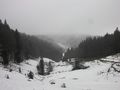
I like that picture.
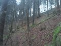
It is now proven that it was steep.
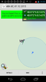
The reception was bad...
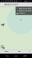
...so I'm uploading a two part proof.
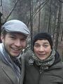
And a stupid grin to complete the gallery.


Achievements
RecentlyChanged and his mother earned the Land geohash achievement
|
RecentlyChanged and his mother earned the Drowned Rat Geohash Honourable Mention
|