Difference between revisions of "2015-12-06 46 16"
imported>GeoEdo (→Photos) |
imported>FippeBot m (Location) |
||
| (5 intermediate revisions by one other user not shown) | |||
| Line 15: | Line 15: | ||
== Expedition == | == Expedition == | ||
| − | Older GeoKid decided she doesn't want to be just dragged to geohashing expeditions anymmore, but she would rather be active geohasher. So, today she became [[User:GeoIva|GeoIva]], and two of us went together | + | Older GeoKid decided she doesn't want to be just dragged to geohashing expeditions anymmore, but she would rather be active geohasher. So, today she became [[User:GeoIva|GeoIva]], and two of us went together on this expedition. |
We took A4 motorway from Zagreb to Cakovec, and there we proceeded on local road that brought us between two small settlements in Medimurje County (Mackovec and Slemenice). There we found dirt road that lead right to the hashpoint. Actually, hashpoint is located at south side of this dirt road. I drove car some 40 meters before hahspoint and there we left car and continued on foot. I probably could get with the car all the way to the hashpoint but I was more concerned with the possibility to turn the car back. | We took A4 motorway from Zagreb to Cakovec, and there we proceeded on local road that brought us between two small settlements in Medimurje County (Mackovec and Slemenice). There we found dirt road that lead right to the hashpoint. Actually, hashpoint is located at south side of this dirt road. I drove car some 40 meters before hahspoint and there we left car and continued on foot. I probably could get with the car all the way to the hashpoint but I was more concerned with the possibility to turn the car back. | ||
| − | The hashpoint is on this dirt road, just next to the edge of the small forest. The rest of the area | + | The hashpoint is on this dirt road, just next to the edge of the small forest. The rest of the area is mainly agricultural land. We took screenshots and pictures of the hashpoint and the surrounding area. We marked the hashpoint with few rocks and with piece of dry corn stalk that we found nearby. The location was quite nice and peaceful and we decided to have a picnic there. We took blanket from car together with available food and drinks and went back to the hashpoint and sat down on the land and enjoyed the moment. |
The dirt road that brought us to the hashpoint is not mapped on OpenStreetMap, so I added this road to OpenStreetMap and claiming OpenStreetMap achievement. | The dirt road that brought us to the hashpoint is not mapped on OpenStreetMap, so I added this road to OpenStreetMap and claiming OpenStreetMap achievement. | ||
| Line 41: | Line 41: | ||
Image:20151206 132317.jpg|Hashpoint | Image:20151206 132317.jpg|Hashpoint | ||
Image:20151206 132848.jpg|Picnic | Image:20151206 132848.jpg|Picnic | ||
| − | Image:Before | + | Image:Before.jpg|OpenStreetMap before contribution |
| − | Image:After | + | Image:After.jpg|OpenStreetMap after contribution |
</gallery> | </gallery> | ||
| Line 60: | Line 60: | ||
| longitude = 16 | | longitude = 16 | ||
| date = 2015-12-06 | | date = 2015-12-06 | ||
| − | | name = | + | | name = GeoEdo and GeoIva |
}} | }} | ||
| Line 74: | Line 74: | ||
| latitude = 46 | | latitude = 46 | ||
| longitude = 16 | | longitude = 16 | ||
| − | | date = 2015-12- | + | | date = 2015-12-06 |
| − | | name = | + | | name = GeoEdo and GeoIva |
}} | }} | ||
| Line 82: | Line 82: | ||
[[Category:Expeditions with photos]] | [[Category:Expeditions with photos]] | ||
[[Category:Coordinates reached]] | [[Category:Coordinates reached]] | ||
| + | {{location|HR|20}} | ||
Latest revision as of 01:31, 7 August 2019
| Sun 6 Dec 2015 in 46,16: 46.4338856, 16.4378608 geohashing.info google osm bing/os kml crox |
Location
On a dirt road next to a small forest between Mackovec and Slemenice in Medimurje County, Croatia.
Participants
Expedition
Older GeoKid decided she doesn't want to be just dragged to geohashing expeditions anymmore, but she would rather be active geohasher. So, today she became GeoIva, and two of us went together on this expedition.
We took A4 motorway from Zagreb to Cakovec, and there we proceeded on local road that brought us between two small settlements in Medimurje County (Mackovec and Slemenice). There we found dirt road that lead right to the hashpoint. Actually, hashpoint is located at south side of this dirt road. I drove car some 40 meters before hahspoint and there we left car and continued on foot. I probably could get with the car all the way to the hashpoint but I was more concerned with the possibility to turn the car back.
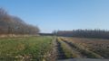
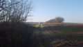
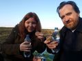
The hashpoint is on this dirt road, just next to the edge of the small forest. The rest of the area is mainly agricultural land. We took screenshots and pictures of the hashpoint and the surrounding area. We marked the hashpoint with few rocks and with piece of dry corn stalk that we found nearby. The location was quite nice and peaceful and we decided to have a picnic there. We took blanket from car together with available food and drinks and went back to the hashpoint and sat down on the land and enjoyed the moment.
The dirt road that brought us to the hashpoint is not mapped on OpenStreetMap, so I added this road to OpenStreetMap and claiming OpenStreetMap achievement.
Tracklog
Expedition tracklog

Expedition tracklog on Wikiloc
Photos
Hashpoint is in front of us
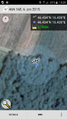
Proof of correct location

Proof of correct date

Expedition team
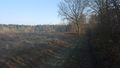
View from hashpoint
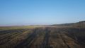
View from hashpoint
Hashmobile from hashpoint
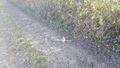
Hashpoint
Picnic
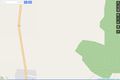
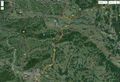
OpenStreetMap before contribution
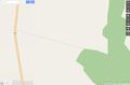
OpenStreetMap after contribution


Achievements
GeoEdo earned the Consecutive geohash achievement
|
GeoEdo and GeoIva earned the Picnic achievement
|
GeoEdo earned the OpenStreetMap achievement
|
GeoEdo and GeoIva earned the Land geohash achievement
|