Difference between revisions of "2015-12-07 62 25"
imported>Nightpanda (→Photos) |
m |
||
| (9 intermediate revisions by 3 users not shown) | |||
| Line 34: | Line 34: | ||
== Expedition == | == Expedition == | ||
<!-- how it all turned out. your narrative goes here. --> | <!-- how it all turned out. your narrative goes here. --> | ||
| − | [[File:2015-12-07 62 25 _DSC3454.png | | + | [[File:2015-12-07 62 25 _DSC3454.png |200px|thumb|left|Hashpoint selfie of Nightpanda]] [[File:2015-12-07 62 25 _DSC3465.jpg |300px|thumb|right| Yellow-dude ^_^]] The challenge came from not owning a GPS-device. But my [[User:Tilley|brother]] assured me there was this thing called no-batteries achievement, and therefore we must achievement-hunt. The satellite picture was detailed enough to pin point the exact location, which I easily reached. A brisk walk through the town, the location was rather familiar since I've biked through there a couple of times. It's close to Jyväskylä's GameLab, a place of game development training. So bim bam boom, a couple of photos to prove I was there. You can clearly see the chimney at the left of me and the clear blue of the..window shaders? The other proof being the picture of the building and the slope which is clearly visible in the satellite photo. Next to the hashpoint there was what appeared to be a graveyard of old bikes. Or maybe it had something to do with fixing them up.. The weird yellow graffiti dude encouraged me on my way home, cheering me for a point well reached. |
| + | |||
| + | The distance flown by a crow was around 1.5km, but taking the extra walk through the other agendas increased the distance walked. So close by that easily completed the walking achievement. Whether was windy and cold, but not below zero. I checked the satellite picture, knew the area well enough to pin point the exact location. Thus I believe the No Batteries Achievement was accomplished. The bags on the ground are roughly within 1 meter of the point. | ||
| − | |||
| − | |||
| − | |||
== Photos == | == Photos == | ||
| Line 46: | Line 45: | ||
--> | --> | ||
<gallery perrow="5"> | <gallery perrow="5"> | ||
| − | Image:2015-12- | + | Image:2015-12-07_62_25_DSC3450.jpg | The building behind the hashpoint and the slope [[Category: Meetup on 2015-12-07]][[Category: Meetup in 62 25]] |
| − | Image:2015-12- | + | Image:2015-12-07_62_25_DSC3464.jpg | Graveyard of bikes [[Category: Meetup on 2015-12-07]][[Category: Meetup in 62 25]] |
| − | Image:2015-12- | + | Image:2015-12-07_62_25_DSC3460.jpg | A grim view from the hashpoint and the December weather [[Category: Meetup on 2015-12-07]][[Category: Meetup in 62 25]] |
| + | Image:2015-12-07_62_25_satelliteView.jpg | Satellite picture of the hashpoint [[Category: Meetup on 2015-12-07]][[Category: Meetup in 62 25]] | ||
</gallery> | </gallery> | ||
| Line 71: | Line 71: | ||
}} | }} | ||
| − | + | {{Puppet Master Geohash | |
| − | + | | latitude = 62 | |
| − | [[ | + | | longitude = 25 |
| − | + | | date = 2015-12-07 | |
| − | + | | puppet = [[User:Nightpanda|Nightpanda]] | |
| − | + | | name = [[User:Tilley|Tilley]] | |
| − | [[ | + | | image = 2015-12-07_62_25_DSC3454.png |
| − | -- | + | }} |
| − | |||
| − | |||
| − | |||
[[Category:Expeditions]] | [[Category:Expeditions]] | ||
| − | |||
[[Category:Expeditions with photos]] | [[Category:Expeditions with photos]] | ||
| − | |||
| − | |||
| − | |||
| − | |||
| − | |||
[[Category:Coordinates reached]] | [[Category:Coordinates reached]] | ||
| − | + | {{location|FI|08}} | |
| − | |||
| − | |||
| − | |||
| − | |||
| − | |||
| − | |||
| − | |||
| − | |||
| − | |||
| − | |||
| − | |||
| − | |||
| − | |||
| − | |||
| − | |||
| − | |||
| − | |||
Latest revision as of 15:38, 22 September 2021
| Mon 7 Dec 2015 in 62,25: 62.2351639, 25.7382868 geohashing.info google osm bing/os kml crox |
Location
In Jyväskylä, Keski-Suomi, Finland
Participants
Plans
As I woke up, there was a command in my head: "You will go to the hashpoint." The jedi powers of my brother Tilley are strong indeed. So the plan was to integrate this visit with the other things up town. First hit the gym, then get to the library, from there to a local fish market for today's lunch, then finally the hashpoint and back home via the grocery store. Busy busy Panda.
Expedition


The challenge came from not owning a GPS-device. But my brother assured me there was this thing called no-batteries achievement, and therefore we must achievement-hunt. The satellite picture was detailed enough to pin point the exact location, which I easily reached. A brisk walk through the town, the location was rather familiar since I've biked through there a couple of times. It's close to Jyväskylä's GameLab, a place of game development training. So bim bam boom, a couple of photos to prove I was there. You can clearly see the chimney at the left of me and the clear blue of the..window shaders? The other proof being the picture of the building and the slope which is clearly visible in the satellite photo. Next to the hashpoint there was what appeared to be a graveyard of old bikes. Or maybe it had something to do with fixing them up.. The weird yellow graffiti dude encouraged me on my way home, cheering me for a point well reached.
The distance flown by a crow was around 1.5km, but taking the extra walk through the other agendas increased the distance walked. So close by that easily completed the walking achievement. Whether was windy and cold, but not below zero. I checked the satellite picture, knew the area well enough to pin point the exact location. Thus I believe the No Batteries Achievement was accomplished. The bags on the ground are roughly within 1 meter of the point.
Photos
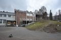
The building behind the hashpoint and the slope
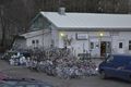
Graveyard of bikes
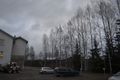
A grim view from the hashpoint and the December weather
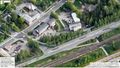
Satellite picture of the hashpoint


Achievements
Nightpanda earned the No Batteries Geohash Achievement
|
Nightpanda earned the Land geohash achievement
|
Nightpanda earned the Walk geohash Achievement
|
Tilley earned the Puppet Master Geohash achievement
|