Difference between revisions of "2015-12-13 47 9"
imported>RecentlyChanged ([live] I did it! At first I ws really afraid it would be out of reach. But it was on top of the green wall, so my arm was enough to reach it.) |
imported>FippeBot m (Location) |
||
| (5 intermediate revisions by 2 users not shown) | |||
| Line 19: | Line 19: | ||
== Location == | == Location == | ||
| − | in Kreuzlingen, | + | in Kreuzlingen, Switzerland. Not far from the german border. |
== Participants == | == Participants == | ||
| Line 35: | Line 35: | ||
*I did it! | *I did it! | ||
At first I ws really afraid it would be out of reach. But it was on top of the green wall, so my arm was enough to reach it. -- [[User:RecentlyChanged|RecentlyChanged]] ([[User_talk:RecentlyChanged|talk]]) [http://www.openstreetmap.org/?lat=47.64529100&lon=9.19592140&zoom=16&layers=B000FTF @47.6453,9.1959] 09:18, 13 December 2015 (CET) | At first I ws really afraid it would be out of reach. But it was on top of the green wall, so my arm was enough to reach it. -- [[User:RecentlyChanged|RecentlyChanged]] ([[User_talk:RecentlyChanged|talk]]) [http://www.openstreetmap.org/?lat=47.64529100&lon=9.19592140&zoom=16&layers=B000FTF @47.6453,9.1959] 09:18, 13 December 2015 (CET) | ||
| − | == | + | |
| − | + | *Forgot the proof screenshot. But tracklog and geotags should be enough -- [[User:RecentlyChanged|RecentlyChanged]] ([[User_talk:RecentlyChanged|talk]]) [http://www.openstreetmap.org/?lat=47.64493700&lon=9.19750920&zoom=16&layers=B000FTF @47.6449,9.1975] 09:19, 13 December 2015 (CET) | |
| + | |||
| + | Green wall just means bush by the way. | ||
| + | Yeah I had to be home in time, I was. | ||
| + | It was nice so early in the morning. | ||
| + | Cold, misty and calm, that was nice. | ||
| + | I got a little bit confused after I almost got on a swiss highway which I had not paid for. | ||
| + | Ok, I got on the swiss highway for a few hundred meters but turned on the next possible point. | ||
| + | Breaking the rules in Switzerland can be very expensive, but I was lucky. | ||
| + | |||
== Photos == | == Photos == | ||
| − | |||
| − | |||
| − | |||
<gallery perrow="5"> | <gallery perrow="5"> | ||
| + | Image:2015-12-13_47_9_RecentlyChanged_1449994732028.jpg|Stupid grin [http://www.openstreetmap.org/?lat=47.64515160&lon=9.19639340&zoom=16&layers=B000FTF @47.6452,9.1964] | ||
| + | File:2015-12-13 47 9 mistylake.jpg | The lake (a bit north of the hashpoint) | ||
| + | File:2015-12-13_47_9_thehshpoint.jpg | The hashpoint itself (it was so early!) | ||
</gallery> | </gallery> | ||
== Achievements == | == Achievements == | ||
{{#vardefine:ribbonwidth|800px}} | {{#vardefine:ribbonwidth|800px}} | ||
| − | + | {{land geohash | |
| − | + | | latitude = 47 | |
| − | + | | longitude = 9 | |
| − | + | | date = 2015-12-13 | |
| − | [[ | + | | name = [[User:RecentlyChanged|RecentlyChanged]] ([[User_talk:RecentlyChanged|talk]]) |
| + | }} | ||
| + | {{Border geohash achievement | ||
| + | | latitude = 47 | ||
| + | | longitude = 9 | ||
| + | | date = 2015-12-13 | ||
| + | | name = [[User:RecentlyChanged|RecentlyChanged]] ([[User_talk:RecentlyChanged|talk]]) | ||
| + | | country1 = Germany | ||
| + | | country2 = Switzerland | ||
| + | }} | ||
| + | {{consecutive geohash | ||
| − | + | | count = 2 | |
| − | + | | latitude = 48 | |
| − | [[ | + | | longitude = 8 |
| − | + | | date = 2015-12-12 | |
| + | | name = [[User:RecentlyChanged|RecentlyChanged]] ([[User_talk:RecentlyChanged|talk]]) | ||
| − | + | }} | |
| + | {{Minesweeper geohash | ||
| + | | graticule = Pforzheim, Germany | ||
| + | | ranknumber = 6 | ||
| + | | n = true | ||
| + | | e = true | ||
| + | | se = true | ||
| + | | s = true | ||
| + | | sw = true | ||
| + | | w = true | ||
| + | | name = [[User:RecentlyChanged|RecentlyChanged]] ([[User_talk:RecentlyChanged|talk]]) | ||
| + | }} | ||
| − | |||
[[Category:Expeditions]] | [[Category:Expeditions]] | ||
| − | |||
[[Category:Expeditions with photos]] | [[Category:Expeditions with photos]] | ||
| − | |||
| − | |||
| − | |||
| − | |||
| − | |||
[[Category:Coordinates reached]] | [[Category:Coordinates reached]] | ||
| − | + | {{location|CH|TG}} | |
| − | |||
| − | |||
| − | |||
| − | |||
| − | |||
| − | |||
| − | |||
| − | |||
| − | |||
| − | |||
| − | |||
| − | |||
| − | |||
| − | |||
| − | |||
| − | |||
| − | |||
Latest revision as of 06:07, 15 August 2019
| Sun 13 Dec 2015 in 47,9: 47.6467395, 9.1955804 geohashing.info google osm bing/os kml crox |
Location
in Kreuzlingen, Switzerland. Not far from the german border.
Participants
RecentlyChanged (talk) 10:30, 11 December 2015 (EST)
Plans
RecentlyChanged (talk) will be in Konstanz anyway on sunday morning, so it is possible. I really hope to go there, I never hashed in 47 9 and maybe one of the swiss hashers will be there too? Either I will be there at midnight or early in the morning (I have to leave Konstanz at least around 10am so I mean really early for a sunday.
Expedition
- I did it!
At first I ws really afraid it would be out of reach. But it was on top of the green wall, so my arm was enough to reach it. -- RecentlyChanged (talk) @47.6453,9.1959 09:18, 13 December 2015 (CET)
- Forgot the proof screenshot. But tracklog and geotags should be enough -- RecentlyChanged (talk) @47.6449,9.1975 09:19, 13 December 2015 (CET)
Green wall just means bush by the way. Yeah I had to be home in time, I was. It was nice so early in the morning. Cold, misty and calm, that was nice. I got a little bit confused after I almost got on a swiss highway which I had not paid for. Ok, I got on the swiss highway for a few hundred meters but turned on the next possible point. Breaking the rules in Switzerland can be very expensive, but I was lucky.
Photos

Stupid grin @47.6452,9.1964
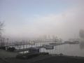
The lake (a bit north of the hashpoint)
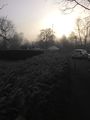
The hashpoint itself (it was so early!)


Achievements
RecentlyChanged (talk) earned the Land geohash achievement
|
RecentlyChanged (talk) earned the Border geohash achievement
|
RecentlyChanged (talk) earned the Consecutive geohash achievement
|
RecentlyChanged (talk) achieved level 6 of the Minesweeper Geohash achievement
|