Difference between revisions of "2015-12-21 47 -122"
From Geohashing
imported>Zebburkeconte (Created page with "{{subst:Expedition |lat = 47 |lon = -122 |date = 2015-12-21 }}") |
imported>FippeBot m (Location) |
||
| (11 intermediate revisions by 2 users not shown) | |||
| Line 19: | Line 19: | ||
== Location == | == Location == | ||
| − | + | Sidewalk on First Hill. | |
== Participants == | == Participants == | ||
| − | + | [[User:Zebburkeconte|zebburkeconte]] | |
| − | |||
| − | + | [[User:benkaiser|benkaiser]] | |
| − | |||
== Expedition == | == Expedition == | ||
| − | + | '''zebburkeconte''' | |
| − | + | Most straightforward geohash ever. Just a few miles away, on a sidewalk. Couldn't be better. I just drove over and snapped a photo. | |
| − | |||
== Photos == | == Photos == | ||
| Line 38: | Line 35: | ||
Image:2012-##-## ## ## Alpha.jpg | Witty Comment | Image:2012-##-## ## ## Alpha.jpg | Witty Comment | ||
--> | --> | ||
| + | '''benkaiser''' | ||
| + | <gallery perrow="5"> | ||
| + | Image:IMG_20151221_203503.jpg| Door next to geohash point | ||
| + | Image:2015-12-21 47 -122 selfie.jpg| Selfie in front of the cathedral across the road | ||
| + | Image:2015-12-21 47 -122 screenshot.png| Screenshot at the hash | ||
| + | </gallery> | ||
| + | '''zebburkeconte''' | ||
<gallery perrow="5"> | <gallery perrow="5"> | ||
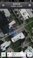
| + | Image:2015-12-21 47 -122 1.jpg| Proof | ||
| + | Image:2015-12-21 47 -122 2.jpg| Selfie at hash | ||
</gallery> | </gallery> | ||
| Line 44: | Line 50: | ||
{{#vardefine:ribbonwidth|800px}} | {{#vardefine:ribbonwidth|800px}} | ||
<!-- Add any achievement ribbons you earned below, or remove this section --> | <!-- Add any achievement ribbons you earned below, or remove this section --> | ||
| + | {{land geohash | ||
| + | | latitude = 47 | ||
| + | | longitude = -122 | ||
| + | | date = 2015-12-21 | ||
| + | | name = [[User:Zebburkeconte|Zebburkeconte]] | ||
| + | }} | ||
| + | {{land geohash | ||
| + | | latitude = 47 | ||
| + | | longitude = -122 | ||
| + | | date = 2015-12-21 | ||
| + | | name = [[User:benkaiser|benkaiser]] | ||
| + | }} | ||
| + | {{drag-along | ||
| + | | latitude = 47 | ||
| + | | longitude = -122 | ||
| + | | date = 2015-12-21 | ||
| + | | partner = Hayden | ||
| + | | image = 2015-12-21_47_-122_selfie.jpg | ||
| + | }} | ||
| − | |||
| − | |||
| − | |||
| − | |||
| − | |||
| − | |||
| − | |||
| − | |||
| − | |||
| − | |||
| − | |||
| − | |||
[[Category:Expeditions]] | [[Category:Expeditions]] | ||
| − | + | [[Category:Expeditions with photos]] | |
| − | [[Category:Expeditions with photos]] | ||
| − | |||
| − | |||
| − | |||
| − | |||
| − | |||
[[Category:Coordinates reached]] | [[Category:Coordinates reached]] | ||
| − | + | {{location|US|WA|KN}} | |
| − | |||
| − | |||
| − | |||
| − | |||
| − | |||
| − | |||
| − | |||
| − | |||
| − | |||
| − | |||
| − | |||
| − | |||
| − | |||
| − | |||
| − | |||
| − | |||
| − | |||
Latest revision as of 06:12, 15 August 2019
| Mon 21 Dec 2015 in 47,-122: 47.6076514, -122.3270839 geohashing.info google osm bing/os kml crox |
Location
Sidewalk on First Hill.
Participants
Expedition
zebburkeconte
Most straightforward geohash ever. Just a few miles away, on a sidewalk. Couldn't be better. I just drove over and snapped a photo.
Photos
benkaiser
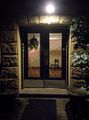
Door next to geohash point
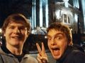
Selfie in front of the cathedral across the road
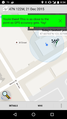
Screenshot at the hash


zebburkeconte

Proof
Selfie at hash


Achievements
Zebburkeconte earned the Land geohash achievement
|
benkaiser earned the Land geohash achievement
|
This user earned the Drag-along achievement
|