Difference between revisions of "2015-12-25 42 -87"
imported>Meta-alt (Basic outline of page) |
m |
||
| (2 intermediate revisions by 2 users not shown) | |||
| Line 43: | Line 43: | ||
{{bicycle geohash | {{bicycle geohash | ||
| − | |||
| latitude = 42 | | latitude = 42 | ||
| longitude = -87 | | longitude = -87 | ||
| Line 49: | Line 48: | ||
| name = meta-alt | | name = meta-alt | ||
| distance = 17 km | | distance = 17 km | ||
| − | | bothways = true | + | | bothways = true |
| − | |||
| − | |||
}} | }} | ||
| + | [[Category: Expeditions]] | ||
| + | [[Category: Coordinates reached]] | ||
[[Category: Meetup on 2015-12-25]] | [[Category: Meetup on 2015-12-25]] | ||
[[Category: Meetup in 42 -87]] | [[Category: Meetup in 42 -87]] | ||
| + | {{location|US|IL|CO}} | ||
Latest revision as of 10:19, 12 September 2021
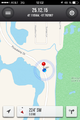
| Fri 25 Dec 2015 in 42,-87: 42.1105637, -87.7620074 geohashing.info google osm bing/os kml crox |
Location
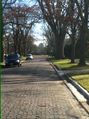
On a road in Winnetka, IL, by the Skokie Lagoons.
Participants
Plans
I checked the geohash coordinates just before going to bed the night of the 24th and was quite excited to note that this day's geohash was only a few miles from my house - it was a Christmas miracle! As per usual, my plan was to bike.
Expedition
The trip went smoothly without incident. This being the Midwest, the ride was flat the whole way. I borrowed my brother's bike (as of yet unnamed, so we can call it Lambda), leaving around 11:35. I passed my ex high school and took the Green Bay Trail. I got to the hashpoint at noon, on a street with a nice view of the Skokie Lagoons. I took a few pictures then headed back home, arriving around 12:25.
Photos
Proof
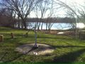
A well, but no uncomfortable truths

Me at the hashpoint! (Ok, maybe the white balance is a bit off)
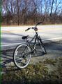
My brother's bike by the hashpoint
Nice view of the Bahá'í Temple on my way back


Achievements
meta-alt earned the Land geohash achievement
|
meta-alt earned the Bicycle geohash achievement
|