Difference between revisions of "2015-12-28 -37 147"
From Geohashing
imported>Felix Dance ([live picture]Dinner Plain [http://www.openstreetmap.org/?lat=-37.01622110&lon=147.22556690&zoom=16&layers=B000FTF @-37.0162,147.2256]) |
imported>Felix Dance (added expedition) |
||
| Line 1: | Line 1: | ||
| + | [[Image:{{{image|Geohash 2015-12-28 -37 147 03 Group.JPG }}}|thumb|150px|left]] | ||
| − | |||
| − | |||
| − | |||
| − | |||
| − | |||
| − | |||
| − | |||
| − | |||
| − | |||
{{meetup graticule | {{meetup graticule | ||
| lat=-37 | | lat=-37 | ||
| Line 19: | Line 11: | ||
== Location == | == Location == | ||
| − | + | Off a walking track near Dinner Plain, adjacent to Mount Hotham, in the Victorian Alps. | |
== Participants == | == Participants == | ||
| − | + | *[[User:Felix Dance|Felix Dance]] | |
| − | + | *[[User:Stevage|Stevage]] | |
| − | + | *[[User:Lachie|Lachie]] | |
| − | + | *Rhonda | |
| − | + | *Matt | |
== Expedition == | == Expedition == | ||
| − | + | [https://goo.gl/maps/Fyqcj4nX6WH2 Here] is the route of our trip. | |
| − | |||
| − | |||
| − | |||
== Photos == | == Photos == | ||
| − | |||
| − | |||
| − | |||
<gallery perrow="5"> | <gallery perrow="5"> | ||
| − | |||
Image:2015-12-28_-37_147_Felix Dance_1451278289989.jpg|Dinner Plain [http://www.openstreetmap.org/?lat=-37.01622110&lon=147.22556690&zoom=16&layers=B000FTF @-37.0162,147.2256] | Image:2015-12-28_-37_147_Felix Dance_1451278289989.jpg|Dinner Plain [http://www.openstreetmap.org/?lat=-37.01622110&lon=147.22556690&zoom=16&layers=B000FTF @-37.0162,147.2256] | ||
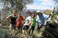
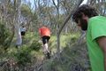
| + | Image:Geohash 2015-12-28 -37 147 01 Walking.JPG|Matt and Lachie walking towards the hash | ||
| + | Image:Geohash 2015-12-28 -37 147 02 GPS.JPG|GPS Proof | ||
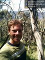
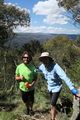
| + | Image:Geohash 2015-12-28 -37 147 03 Group.JPG|At the hash! | ||
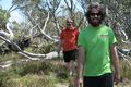
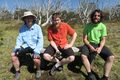
| + | Image:Geohash 2015-12-28 -37 147 04 Hash.JPG|Lachie and Stevage discuss geohashing | ||
| + | Image:Geohash 2015-12-28 -37 147 05 Back.JPG|Heading back up the hill | ||
| + | Image:Geohash 2015-12-28 -37 147 06 Rest.JPG|Bench resting | ||
| + | Image:Geohash 2015-12-28 -37 147 07 View.JPG|The view near the hash | ||
| + | Image:Geohash 2015-12-28 -37 147 08 Road.JPG|The road forward | ||
</gallery> | </gallery> | ||
== Achievements == | == Achievements == | ||
| − | {{ | + | {{bicycle geohash |
| − | + | | latitude = -37 | |
| − | + | | longitude = 137 | |
| − | + | | date = 2015-12-28 | |
| − | + | | name = [[User:Felix Dance|Felix Dance]], [[User:Stevage|Stevage]], [[User:Lachie|Lachie]], Matt and Rhonda | |
| − | [[ | + | | distance = 85 kms |
| − | + | | bothways = TRUE | |
| − | + | | image = Geohash 2015-12-28 -37 147 03 Group.JPG | |
| − | + | }} | |
| − | [[ | ||
| − | |||
| − | |||
| − | |||
| − | |||
| − | |||
| − | |||
[[Category:Expeditions with photos]] | [[Category:Expeditions with photos]] | ||
| − | |||
| − | |||
| − | |||
| − | |||
| − | |||
[[Category:Coordinates reached]] | [[Category:Coordinates reached]] | ||
| − | |||
| − | |||
| − | |||
| − | |||
| − | |||
| − | |||
| − | |||
| − | |||
| − | |||
| − | |||
| − | |||
| − | |||
| − | |||
| − | |||
| − | |||
| − | |||
| − | |||
| − | |||
Revision as of 10:06, 2 January 2016

| Mon 28 Dec 2015 in -37,147: -37.0158495, 147.2259183 geohashing.info google osm bing/os kml crox |
Location
Off a walking track near Dinner Plain, adjacent to Mount Hotham, in the Victorian Alps.
Participants
- Felix Dance
- Stevage
- Lachie
- Rhonda
- Matt
Expedition
Here is the route of our trip.
Photos
Dinner Plain @-37.0162,147.2256
Matt and Lachie walking towards the hash
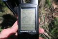
GPS Proof
At the hash!
Lachie and Stevage discuss geohashing
Heading back up the hill
Bench resting
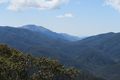
The view near the hash
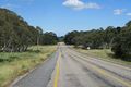
The road forward


Achievements
Felix Dance, Stevage, Lachie, Matt and Rhonda earned the Bicycle geohash achievement
|