Difference between revisions of "2015-12-28 -37 147"
imported>Felix Dance ([live picture]Dinner Plain [http://www.openstreetmap.org/?lat=-37.01622110&lon=147.22556690&zoom=16&layers=B000FTF @-37.0162,147.2256]) |
m |
||
| (10 intermediate revisions by 6 users not shown) | |||
| Line 1: | Line 1: | ||
| + | [[Image:{{{image|Geohash 2015-12-28 -37 147 03 Group.JPG }}}|thumb|150px|left]] | ||
| − | |||
| − | |||
| − | |||
| − | |||
| − | |||
| − | |||
| − | |||
| − | |||
| − | |||
{{meetup graticule | {{meetup graticule | ||
| lat=-37 | | lat=-37 | ||
| Line 19: | Line 11: | ||
== Location == | == Location == | ||
| − | + | Off a walking track near Dinner Plain, adjacent to Mount Hotham, in the Victorian Alps. | |
== Participants == | == Participants == | ||
| − | + | *[[User:Felix Dance|Felix Dance]] | |
| − | + | *[[User:Stevage|Stevage]] | |
| + | *[[User:Lachie|Lachie]] | ||
| + | *Rhonda | ||
| + | *[[User:Mdixon4|Mdixon4]] | ||
| − | == | + | == Expedition - Felix Dance == |
| − | + | The five of us mentioned above had been on a multi-day cycle tour back and forth over the Victorian Alps. On the morning of the second day, waking up from our respective slumbers in the Harrietville Pub backyard, I discovered much to my excitement that the day's geohash was only 620m off our intended route as we were to go past the alpine village of Dinner Plain. This could not be a coincidence and can only be attributed to my recently renewed devotion to the Geohashing Gods and thus they shone favour on the day's location. | |
| − | + | Heading off up the hill towards Mount Hotham - a vertical kilometre or so of climbing in the hot summer sun - I slowly worked my charms on the others to convince them to join me. By the turn-off at Dinner Plain, after a hearty meal, a strong beer and the beginning of our decent, all reservations had been overcome. [Steve's note: actually there were a couple of hold-outs convinced only by the promise to turn around in 30 minutes, come what may.] | |
| − | |||
| − | + | The five of us made bike-progress up the Timber Hill Track walking path towards the hash, but were forced to abandon our vehicles as the stepth increased. Proceeding on foot we soon left the path to descend a steep, rocky escarpment, with the metres ticking down like the altimeter of a depth charge. We had promised ourselves to turn back at 30 minutes, and when we reached the hash we hadn't a minute to spare. | |
| − | + | ||
| + | One of the more grand of the geohashing views I've been to, we took some photos, clambered around the awkward grade of the hash-field and then ascended, bullants, snakes and broken ankles be damned. Soon we were reunited with our bikes and proceeded on with our mission. This would later include the further hash of [[2015-12-31 -36 146]]. | ||
| + | |||
| + | [https://goo.gl/maps/Fyqcj4nX6WH2 Here] is the route of our trip. | ||
== Photos == | == Photos == | ||
| − | |||
| − | |||
| − | |||
<gallery perrow="5"> | <gallery perrow="5"> | ||
| − | |||
Image:2015-12-28_-37_147_Felix Dance_1451278289989.jpg|Dinner Plain [http://www.openstreetmap.org/?lat=-37.01622110&lon=147.22556690&zoom=16&layers=B000FTF @-37.0162,147.2256] | Image:2015-12-28_-37_147_Felix Dance_1451278289989.jpg|Dinner Plain [http://www.openstreetmap.org/?lat=-37.01622110&lon=147.22556690&zoom=16&layers=B000FTF @-37.0162,147.2256] | ||
| + | Image:Geohash 2015-12-28 -37 147 01 Walking.JPG|Matt and Lachie walking towards the hash | ||
| + | Image:Geohash 2015-12-28 -37 147 02 GPS.JPG|GPS Proof | ||
| + | Image:Geohash 2015-12-28 -37 147 03 Group.JPG|At the hash! | ||
| + | Image:Geohash 2015-12-28 -37 147 04 Hash.JPG|Lachie and Stevage discuss geohashing | ||
| + | Image:Geohash 2015-12-28 -37 147 05 Back.JPG|Heading back up the hill | ||
| + | Image:Geohash 2015-12-28 -37 147 06 Rest.JPG|Bench resting | ||
| + | Image:Geohash 2015-12-28 -37 147 07 View.JPG|The view near the hash | ||
| + | Image:Geohash 2015-12-28 -37 147 08 Road.JPG|The road forward | ||
</gallery> | </gallery> | ||
== Achievements == | == Achievements == | ||
| − | {{ | + | {{bicycle geohash |
| − | + | | latitude = -37 | |
| − | + | | longitude = 147 | |
| − | + | | date = 2015-12-28 | |
| − | + | | name = [[User:Felix Dance|Felix Dance]], [[User:Stevage|Stevage]], [[User:Lachie|Lachie]], Matt and Rhonda | |
| − | [[ | + | | distance = 85 kms |
| − | + | | bothways = TRUE | |
| − | + | | image = Geohash 2015-12-28 -37 147 03 Group.JPG | |
| − | + | }} | |
| − | [[ | ||
| − | |||
| − | |||
| − | |||
| − | |||
[[Category:Expeditions]] | [[Category:Expeditions]] | ||
| − | |||
[[Category:Expeditions with photos]] | [[Category:Expeditions with photos]] | ||
| − | |||
| − | |||
| − | |||
| − | |||
| − | |||
[[Category:Coordinates reached]] | [[Category:Coordinates reached]] | ||
| − | + | {{location|AU|VIC|AL}} | |
| − | |||
| − | |||
| − | |||
| − | |||
| − | |||
| − | |||
| − | |||
| − | |||
| − | |||
| − | |||
| − | |||
| − | |||
| − | |||
| − | |||
| − | |||
| − | |||
| − | |||
Latest revision as of 15:39, 22 September 2021

| Mon 28 Dec 2015 in -37,147: -37.0158495, 147.2259183 geohashing.info google osm bing/os kml crox |
Location
Off a walking track near Dinner Plain, adjacent to Mount Hotham, in the Victorian Alps.
Participants
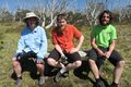
- Felix Dance
- Stevage
- Lachie
- Rhonda
- Mdixon4
Expedition - Felix Dance
The five of us mentioned above had been on a multi-day cycle tour back and forth over the Victorian Alps. On the morning of the second day, waking up from our respective slumbers in the Harrietville Pub backyard, I discovered much to my excitement that the day's geohash was only 620m off our intended route as we were to go past the alpine village of Dinner Plain. This could not be a coincidence and can only be attributed to my recently renewed devotion to the Geohashing Gods and thus they shone favour on the day's location.
Heading off up the hill towards Mount Hotham - a vertical kilometre or so of climbing in the hot summer sun - I slowly worked my charms on the others to convince them to join me. By the turn-off at Dinner Plain, after a hearty meal, a strong beer and the beginning of our decent, all reservations had been overcome. [Steve's note: actually there were a couple of hold-outs convinced only by the promise to turn around in 30 minutes, come what may.]
The five of us made bike-progress up the Timber Hill Track walking path towards the hash, but were forced to abandon our vehicles as the stepth increased. Proceeding on foot we soon left the path to descend a steep, rocky escarpment, with the metres ticking down like the altimeter of a depth charge. We had promised ourselves to turn back at 30 minutes, and when we reached the hash we hadn't a minute to spare.
One of the more grand of the geohashing views I've been to, we took some photos, clambered around the awkward grade of the hash-field and then ascended, bullants, snakes and broken ankles be damned. Soon we were reunited with our bikes and proceeded on with our mission. This would later include the further hash of 2015-12-31 -36 146.
Here is the route of our trip.
Photos
Dinner Plain @-37.0162,147.2256
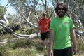
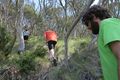
Matt and Lachie walking towards the hash
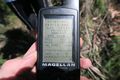
GPS Proof
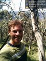
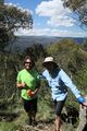
At the hash!
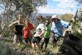
Lachie and Stevage discuss geohashing
Heading back up the hill
Bench resting
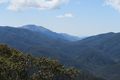
The view near the hash
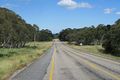
The road forward


Achievements
Felix Dance, Stevage, Lachie, Matt and Rhonda earned the Bicycle geohash achievement
|