Difference between revisions of "2015-12-28 49 8"
imported>DODO (Created page with "{{subst:Expedition |lat = 49 |lon = 8 |date = 2015-12-28 }}") |
imported>FippeBot m (Location) |
||
| (9 intermediate revisions by one other user not shown) | |||
| Line 20: | Line 20: | ||
== Location == | == Location == | ||
<!-- where you've surveyed the hash to be --> | <!-- where you've surveyed the hash to be --> | ||
| + | In the middle of the L540 near Hagenbach. | ||
== Participants == | == Participants == | ||
<!-- who attended: If you link to your wiki user name in this section, your expedition will be picked up by the various statistics generated for geohashing. You may use three tildes ~ as a shortcut to automatically insert the user signature of the account you are editing with. | <!-- who attended: If you link to your wiki user name in this section, your expedition will be picked up by the various statistics generated for geohashing. You may use three tildes ~ as a shortcut to automatically insert the user signature of the account you are editing with. | ||
--> | --> | ||
| + | [[User:DODO|DODO]] | ||
== Plans == | == Plans == | ||
<!-- what were the original plans --> | <!-- what were the original plans --> | ||
| + | Go there in the morning on my bull. | ||
== Expedition == | == Expedition == | ||
<!-- how it all turned out. your narrative goes here. --> | <!-- how it all turned out. your narrative goes here. --> | ||
| + | Things went pretty much as planned - at least at the beginning. Weather was quite foggy and I had to ride without my glasses because they were so wet that I couldn't see anything through them. After 30 kilometers there was a bump in the road, the tablet was swung from the bag at the handlebar, unsnapped from the press buttons and fell down. Well, I wouldn't have mentioned if the tablet wasn't broken. Fortunately it was only the glass and it was still working. So I could continue my way and reached the hash after 1 1/2 hours. I took some pictures, walked on the busy road to get a proof picture but forgot to take a picture of myself. Later I found a bakery and bought some small cakes. Soon I found a nice and sunny place where I enjoyed this gratification. I came back home after 90 KM at 1 pm. | ||
| + | |||
| + | I think, I've been at the hash before on the way to another one. I'll check that. | ||
== Tracklog == | == Tracklog == | ||
<!-- if your GPS device keeps a log, you may post a link here --> | <!-- if your GPS device keeps a log, you may post a link here --> | ||
| + | [https://www.komoot.de/tour/7593235 90 KM bullriding] | ||
== Photos == | == Photos == | ||
| Line 39: | Line 46: | ||
--> | --> | ||
<gallery perrow="5"> | <gallery perrow="5"> | ||
| + | Image:2015-12-28_49_8-1.jpg|to the east (hash is at the left head lamp of the blue car) | ||
| + | Image:2015-12-28_49_8-2.jpg|to the west (and proof of transport) | ||
| + | Image:2015-12-28_49_8-3.jpg|proof | ||
| + | Image:2015-12-28_49_8-4.jpg|hasher (later) with gratification | ||
</gallery> | </gallery> | ||
| Line 44: | Line 55: | ||
{{#vardefine:ribbonwidth|800px}} | {{#vardefine:ribbonwidth|800px}} | ||
<!-- Add any achievement ribbons you earned below, or remove this section --> | <!-- Add any achievement ribbons you earned below, or remove this section --> | ||
| + | {{land geohash | ||
| + | | latitude = 49 | ||
| + | | longitude = 8 | ||
| + | | date = 2015-12-28 | ||
| + | | name = DODO | ||
| + | }} | ||
| − | + | {{Déjà vu geohash | |
| − | + | | latitude = 49 | |
| − | [[ | + | | longitude = 8 |
| + | | date = 2015-12-28 | ||
| + | | olddate = [[2014-06-15_48_7|2014-06-15]] | ||
| + | | name = DODO | ||
| + | }} | ||
| − | + | {{consecutive geohash | |
| − | + | | count = 3 | |
| − | + | | latitude = 49 | |
| − | + | | longitude = 8 | |
| + | | date = 2015-12-26 | ||
| + | | name = DODO | ||
| + | }} | ||
| − | + | [[Category:Coordinates reached]] | |
| − | + | [[Category:Expeditions with photos]] | |
| − | |||
[[Category:Expeditions]] | [[Category:Expeditions]] | ||
| − | + | {{location|DE|RP|GER}} | |
| − | |||
| − | |||
| − | |||
| − | |||
| − | |||
| − | |||
| − | |||
| − | |||
| − | |||
| − | |||
| − | |||
| − | |||
| − | |||
| − | |||
| − | |||
| − | |||
| − | |||
| − | |||
| − | |||
| − | |||
| − | |||
| − | |||
| − | |||
| − | |||
| − | |||
Latest revision as of 06:17, 15 August 2019
| Mon 28 Dec 2015 in 49,8: 49.0158495, 8.2259183 geohashing.info google osm bing/os kml crox |
Location
In the middle of the L540 near Hagenbach.
Participants
Plans
Go there in the morning on my bull.
Expedition
Things went pretty much as planned - at least at the beginning. Weather was quite foggy and I had to ride without my glasses because they were so wet that I couldn't see anything through them. After 30 kilometers there was a bump in the road, the tablet was swung from the bag at the handlebar, unsnapped from the press buttons and fell down. Well, I wouldn't have mentioned if the tablet wasn't broken. Fortunately it was only the glass and it was still working. So I could continue my way and reached the hash after 1 1/2 hours. I took some pictures, walked on the busy road to get a proof picture but forgot to take a picture of myself. Later I found a bakery and bought some small cakes. Soon I found a nice and sunny place where I enjoyed this gratification. I came back home after 90 KM at 1 pm.
I think, I've been at the hash before on the way to another one. I'll check that.
Tracklog
Photos
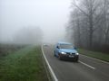
to the east (hash is at the left head lamp of the blue car)
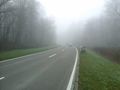
to the west (and proof of transport)
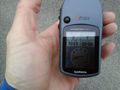
proof
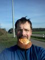
hasher (later) with gratification


Achievements
DODO earned the Land geohash achievement
|
DODO earned the Déjà Vu Geohash Achievement
|
DODO earned the Consecutive geohash achievement
|