Difference between revisions of "2015-12-28 50 11"
imported>Klaus (template) |
imported>FippeBot m (Location) |
||
| (4 intermediate revisions by one other user not shown) | |||
| Line 1: | Line 1: | ||
| + | [[Image:{{{image|2015-12-28 50 11 geohash forest.jpg}}}|thumb|left]] | ||
| − | |||
| − | |||
| − | |||
| − | |||
| − | |||
| − | |||
| − | |||
| − | |||
| − | |||
{{meetup graticule | {{meetup graticule | ||
| lat=50 | | lat=50 | ||
| Line 15: | Line 7: | ||
}} | }} | ||
| − | |||
| − | |||
== Location == | == Location == | ||
| − | + | Forest near Fesselsdorf, Germany | |
== Participants == | == Participants == | ||
| − | + | * [[User:Klaus|Klaus]] and his brother | |
| − | |||
== Plans == | == Plans == | ||
| − | + | Persuade brother and cycle there to get a hash in the [[50,11|Erfurt]] graticule! | |
== Expedition == | == Expedition == | ||
| − | + | We took our parents pedelecs and started at 14:30. Nothing spectacular, we got some fresh air and as we had electric bicycles it was easy to cycle, too. | |
| + | We didn't go to the exact spot of the geohash, because -- according to the GPS -- it was some more metres into the forest where obviously some lumberjacking took place (we even heard the sound of a chainsaw). | ||
| + | I still will count it as reached, because there were no obstacles (except sanity) and we were 10m close. | ||
| − | + | On the way back we made a little detour to see Stadelhofen's newly built mortuary. | |
| − | |||
== Photos == | == Photos == | ||
| − | |||
| − | |||
| − | |||
<gallery perrow="5"> | <gallery perrow="5"> | ||
| + | Image:2015-12-28 50 11 A70 and photovoltaic.jpg | Crossing the A70 and a large photovoltaic field | ||
| + | Image:2015-12-28 50 11 Proof.jpg | Proof | ||
| + | Image:2015-12-28 50 11 geohash forest.jpg | The geohash is some more steps into this forest... | ||
| + | Image:2015-12-28_50_11_proof_lumberjacking.jpg | ... where we didn't go because of (private) lumberjacking and the sound of chainsaws | ||
| + | Image:2015-12-28_50_11_mausoleum_stadelhofen.jpg | Stadelhofen's newly built mortuary | ||
</gallery> | </gallery> | ||
== Achievements == | == Achievements == | ||
{{#vardefine:ribbonwidth|800px}} | {{#vardefine:ribbonwidth|800px}} | ||
| − | + | {{land geohash | |
| + | | latitude = 50 | ||
| + | | longitude = 11 | ||
| + | | date = 2015-12-28 | ||
| + | | name = [[User:Klaus|Klaus]] | ||
| + | }} | ||
| − | + | {{bicycle geohash | |
| − | + | | latitude = 50 | |
| − | [[ | + | | longitude = 11 |
| + | | date = 2015-12-28 | ||
| + | | name = [[User:Klaus|Klaus]] | ||
| + | | distance = 38km | ||
| + | | bothways = true | ||
| + | }} | ||
| − | + | {{Minesweeper geohash | |
| − | + | | graticule = 49,11 | |
| − | + | | ranknumber = 2 | |
| − | + | | s = true | |
| + | | n = true | ||
| + | | name = Klaus | ||
| + | }} | ||
| − | + | {{Minesweeper geohash | |
| + | | graticule = 50,11 | ||
| + | | ranknumber = 1 | ||
| + | | s = true | ||
| + | | name = Klaus | ||
| + | }} | ||
| − | + | {{Template:Drag-along | |
| − | + | | latitude = 50 | |
| − | -- | + | | longitude = 11 |
| − | [[ | + | | date = 2015-12-28 |
| − | + | | name = [[User:Klaus|Klaus]] | |
| − | + | | partner = his brother | |
| − | + | }} | |
| − | |||
| − | |||
| − | |||
| − | |||
| − | |||
| − | |||
| − | |||
| − | |||
| − | |||
| − | |||
| − | |||
| − | |||
| − | |||
| − | |||
| − | |||
| − | |||
| − | + | [[Category:Expeditions]] | |
| + | [[Category:Expeditions with photos]] | ||
| + | [[Category:Coordinates reached]] | ||
| + | {{location|DE|BY|LIF}} | ||
Latest revision as of 01:34, 7 August 2019

| Mon 28 Dec 2015 in 50,11: 50.0158495, 11.2259183 geohashing.info google osm bing/os kml crox |
Location
Forest near Fesselsdorf, Germany
Participants
- Klaus and his brother
Plans
Persuade brother and cycle there to get a hash in the Erfurt graticule!
Expedition
We took our parents pedelecs and started at 14:30. Nothing spectacular, we got some fresh air and as we had electric bicycles it was easy to cycle, too. We didn't go to the exact spot of the geohash, because -- according to the GPS -- it was some more metres into the forest where obviously some lumberjacking took place (we even heard the sound of a chainsaw). I still will count it as reached, because there were no obstacles (except sanity) and we were 10m close.
On the way back we made a little detour to see Stadelhofen's newly built mortuary.
Photos
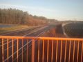
Crossing the A70 and a large photovoltaic field
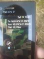
Proof
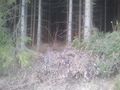
The geohash is some more steps into this forest...
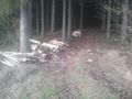
... where we didn't go because of (private) lumberjacking and the sound of chainsaws
Stadelhofen's newly built mortuary


Achievements
Klaus earned the Land geohash achievement
|
Klaus earned the Bicycle geohash achievement
|
Klaus achieved level 2 of the Minesweeper Geohash achievement
|
Klaus achieved level 1 of the Minesweeper Geohash achievement
|
Klaus earned the Drag-along achievement
|