Difference between revisions of "2015-12-30 49 8"
imported>DODO (→Plans) |
imported>FippeBot m (Location) |
||
| (5 intermediate revisions by one other user not shown) | |||
| Line 20: | Line 20: | ||
== Location == | == Location == | ||
<!-- where you've surveyed the hash to be --> | <!-- where you've surveyed the hash to be --> | ||
| − | At the entrance of something( | + | At the entrance of something(that turned out to be a geese stable) in Nußloch (nut hole). |
== Participants == | == Participants == | ||
| Line 33: | Line 33: | ||
== Expedition == | == Expedition == | ||
<!-- how it all turned out. your narrative goes here. --> | <!-- how it all turned out. your narrative goes here. --> | ||
| + | I left my tablet in my room, where big lady's big daughter is sleeping while she visits us over christmas, and so I couldn't start before 10:30. Thus I couldn't reach the hash half an hour later as planned. | ||
| + | |||
| + | The weather was sunny and I decided to go to the hash by bike. The ride went so fine that I can't tell much about it. In Nußloch I found an aerial railway for schell limestone bringing it from the nearby quarry to the cement plant in Leimen. It is almost 100 years old and still working fine. A short time later I had to conquer a rise and there I reached the hash. The unidentified structure on google turned out to be a geese stable and when I came near the gate the three geese made an remarkable noise. But they seemed to be proud because they got quiet when I took some pictures of them. I took some more pictures, left a very improvised mark and rode home again. I reached home at 13:30. | ||
| + | |||
| + | I didn't cross my own way on the whole ride and -as the hash was directly next to the road- I didn't even cross it there (maybe when I searched the plant for the mark, but I don't think that counts). I had to cross the bridge in Speyer twice but did so on the right side both times and I think you even can see the difference on the tracklog. | ||
== Tracklog == | == Tracklog == | ||
<!-- if your GPS device keeps a log, you may post a link here --> | <!-- if your GPS device keeps a log, you may post a link here --> | ||
| + | [https://www.komoot.de/tour/7612573 52 KM by bike] | ||
== Photos == | == Photos == | ||
| Line 42: | Line 48: | ||
--> | --> | ||
<gallery perrow="5"> | <gallery perrow="5"> | ||
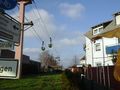
| + | Image:2015-12-30_49_8-1.jpg|aerial railway | ||
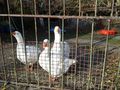
| + | Image:2015-12-30_49_8-2.jpg|hash-geese (now quite) | ||
| + | Image:2015-12-30_49_8-9.png|proof | ||
| + | Image:2015-12-30_49_8-4.jpg|view to the south | ||
| + | Image:2015-12-30_49_8-5.jpg|view to the west | ||
| + | Image:2015-12-30_49_8-6.jpg|view to the east (in the north are the geese) | ||
| + | Image:2015-12-30_49_8-3.jpg|view to the hasher | ||
| + | Image:2015-12-30_49_8-7.jpg|proof of transport | ||
| + | Image:2015-12-30_49_8-8.jpg|little mark | ||
</gallery> | </gallery> | ||
| Line 47: | Line 62: | ||
{{#vardefine:ribbonwidth|800px}} | {{#vardefine:ribbonwidth|800px}} | ||
<!-- Add any achievement ribbons you earned below, or remove this section --> | <!-- Add any achievement ribbons you earned below, or remove this section --> | ||
| + | {{land geohash | ||
| + | | latitude = 49 | ||
| + | | longitude = 8 | ||
| + | | date = 2015-12-30 | ||
| + | | name = DODO | ||
| + | }} | ||
| − | + | {{Template:Tron | |
| − | + | | latitude = 49 | |
| − | + | | longitude = 8 | |
| + | | date = 2015-12-30 | ||
| + | | name = DODO | ||
| + | | possessive = his | ||
| + | }} | ||
| − | + | {{bicycle geohash | |
| − | + | | latitude = 49 | |
| − | + | | longitude = 8 | |
| − | + | | date = 2015-12-30 | |
| + | | name = DODO | ||
| + | | distance = 52 KM | ||
| + | }} | ||
| − | |||
| − | |||
[[Category:Expeditions]] | [[Category:Expeditions]] | ||
| − | |||
[[Category:Expeditions with photos]] | [[Category:Expeditions with photos]] | ||
| − | |||
| − | |||
| − | |||
| − | |||
| − | |||
[[Category:Coordinates reached]] | [[Category:Coordinates reached]] | ||
| − | + | {{location|DE|BW|HD}} | |
| − | |||
| − | |||
| − | |||
| − | |||
| − | |||
| − | |||
| − | |||
| − | |||
| − | |||
| − | |||
| − | |||
| − | |||
| − | |||
| − | |||
| − | |||
| − | |||
| − | |||
Latest revision as of 06:19, 15 August 2019
| Wed 30 Dec 2015 in 49,8: 49.3302846, 8.6976696 geohashing.info google osm bing/os kml crox |
Location
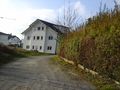
At the entrance of something(that turned out to be a geese stable) in Nußloch (nut hole).
Participants
Plans
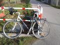
Go there by bike in the morning. I hope to be there around 11. I'll try a tron achievement, but I have to cross the bridge twice (on different sides).
Expedition
I left my tablet in my room, where big lady's big daughter is sleeping while she visits us over christmas, and so I couldn't start before 10:30. Thus I couldn't reach the hash half an hour later as planned.
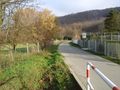
The weather was sunny and I decided to go to the hash by bike. The ride went so fine that I can't tell much about it. In Nußloch I found an aerial railway for schell limestone bringing it from the nearby quarry to the cement plant in Leimen. It is almost 100 years old and still working fine. A short time later I had to conquer a rise and there I reached the hash. The unidentified structure on google turned out to be a geese stable and when I came near the gate the three geese made an remarkable noise. But they seemed to be proud because they got quiet when I took some pictures of them. I took some more pictures, left a very improvised mark and rode home again. I reached home at 13:30.
I didn't cross my own way on the whole ride and -as the hash was directly next to the road- I didn't even cross it there (maybe when I searched the plant for the mark, but I don't think that counts). I had to cross the bridge in Speyer twice but did so on the right side both times and I think you even can see the difference on the tracklog.
Tracklog
Photos
aerial railway
hash-geese (now quite)
proof
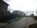
view to the south
view to the west
view to the east (in the north are the geese)

view to the hasher
proof of transport
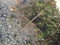
little mark


Achievements
DODO earned the Land geohash achievement
|
DODO earned the Tron achievement
|
DODO earned the Bicycle geohash achievement
|