Difference between revisions of "2016-01-01 49 8"
imported>Yakamoz ([live picture]we only had 2,6 km to go) |
imported>FippeBot m (Location) |
||
| (29 intermediate revisions by 5 users not shown) | |||
| Line 1: | Line 1: | ||
| − | + | [[Image:2016-01-01 49 8 hp.jpg|thumb|left|Tree at the Hashpoint]] | |
| − | |||
| − | |||
| − | [[Image: | ||
| − | |||
| − | |||
| − | |||
| − | |||
| − | |||
| − | |||
{{meetup graticule | {{meetup graticule | ||
| lat=49 | | lat=49 | ||
| Line 19: | Line 10: | ||
== Location == | == Location == | ||
| − | + | ||
| + | In a wood near [[wikipedia:Seeheim-Jugenheim|Seeheim]] | ||
== Participants == | == Participants == | ||
| − | + | ||
| − | -- | + | *[[User:Q-Owl|Q-Owl]] |
| + | *[[User:Q-Owla|Q-Owla]] | ||
| + | *[[User:Yakamoz|Yakamoz]] | ||
| + | *[[User:Rincewind|Rincewind]] | ||
| + | *[[User:tads|tads]] | ||
| + | *[[User:Cuxi|Cuxi]] | ||
== Plans == | == Plans == | ||
| − | + | ||
| + | === Q-Owl and Q-Owla === | ||
| + | Drive near the hashpoint (about 12:30) , find it, walk back to the car, find some caches and drive home. | ||
| + | |||
| + | === Yakamoz and Rincewind === | ||
| + | We don't want to miss the first geohash in 2016 which is very close to us. Drive near the hashpoint (about 14:00), walk there, drive back home and have a New Year's lunch. | ||
| + | |||
| + | === Cuxi and tads === | ||
| + | Drive near the hashpoint (about 16:30), find it, find some geocache and drive home. | ||
== Expedition == | == Expedition == | ||
| − | + | ||
| + | === Q-Owl and Q-Owla === | ||
| + | We reached the hashpoint about 12:45, found it, marked the tree next to the hp, went back to the car and found two caches today: GC603CT "Mystery Cache, I'm gone" (distance 900 m) and GC34TMY "Paradies der Libellen" (paradise of the dragonflies). | ||
| + | |||
| + | === Yakamoz and Rincewind === | ||
| + | We parked next to allotment gardens and walked into the forest. The geohash has been located on a forest track. We did our geohash dance and took some photos. Unfortunately, we didn't see Q-Owl's marker. On our way back we a pony behind a fence accompanied us. It was a very easy and close geohash for us! | ||
| + | |||
| + | We wish all geohashers a happy and great new year with many successful geohashes! We hope to meet you at next geohash points. In particular, we hope to geohash together with Mampfred, EmmJay and LadyBB again this year ;-) | ||
| + | |||
| + | === Cuxi and tads === | ||
| + | Happy new year everybody! | ||
| + | We went to the hashpoint at 16:30, but did not recognize any marks at the location as it began to dawn already. We thus put a wooden X on the ground next to the trail. On the pictures that we took, we now have found the "xkcd" mark by Q-Owl and Q-Owla. | ||
| + | Additionally we discovered GC3ACCJ "Waldschrats Geheimnis" (distance 370m). | ||
== Tracklog == | == Tracklog == | ||
| − | + | ||
| + | ?? | ||
== Photos == | == Photos == | ||
| − | + | ||
| − | + | === Q-Owl and Q-Owla === | |
| − | -- | ||
<gallery perrow="5"> | <gallery perrow="5"> | ||
| + | Image:2016-01-01 49 8 proof.png | Proof 0.36 m ;-) | ||
| + | Image:2016-01-01 49 8 hp.jpg | Marked tree next to the hashpoint. | ||
| + | Image:2016-01-01 49 8 w.jpg | View W | ||
| + | Image:2016-01-01 49 8 e.jpg | View E | ||
| + | Image:2016-01-01 49 8 grin.jpg | Grin² | ||
| + | </gallery> | ||
| + | === Yakamoz and Rincewind === | ||
| + | <gallery perrow="5"> | ||
Image:2016-01-01_49_8_yakamoz_1451658951929.jpg|we only had 2,6 km to go | Image:2016-01-01_49_8_yakamoz_1451658951929.jpg|we only had 2,6 km to go | ||
| + | Image:2016-01-01_49_8_yakamoz_1451659180967.jpg|very close to the point | ||
| + | Image:2016-01-01_49_8_hashyakamoz.jpg|Yakamoz watching a woodpecker work a tree next to the hashpoint. | ||
| + | Image:2016-01-01_49_8_hashsurroundings.jpg|Nice view down the path that led us to the hash. | ||
| + | Image:2015-01-01_49_8_hashgrin.jpg|Woohooo! | ||
| + | Image:2016-01-01_49_8_hashpony.jpg|The pony living 50m from the hash, with a very barky white German Shepherd and some chicken as neighbours. | ||
| + | |||
| + | |||
| + | </gallery> | ||
| + | |||
| + | === Cuxi and tads === | ||
| + | <gallery perrow="5"> | ||
| + | Image:tads_2016-01-01_49_8_proof.png | proof | ||
| + | Image:tads_2016-01-01_49_8_mark.jpg | additional mark | ||
</gallery> | </gallery> | ||
== Achievements == | == Achievements == | ||
{{#vardefine:ribbonwidth|800px}} | {{#vardefine:ribbonwidth|800px}} | ||
| − | + | {{land geohash | |
| + | | latitude = 49 | ||
| + | | longitude = 8 | ||
| + | | date = 2016-01-01 | ||
| + | | name = Q-Owl, Q-Owla, Yakamoz, Rincewind, tads and Cuxi | ||
| + | }} | ||
| + | {{gratuitous ribbon | ||
| + | | icon = Avoid achievement.png | ||
| + | | latitude = 49 | ||
| + | | longitude = 8 | ||
| + | | date = 2016-01-01 | ||
| + | | achievement = Avoid Each Other Achievement | ||
| + | | description = launching three independent expeditions without meeting up at the | ||
| + | | name = Q-Owl, Q-Owla, Yakamoz, Rincewind, tads and Cuxi | ||
| + | }} | ||
| − | |||
| − | |||
| − | |||
| − | |||
| − | |||
| − | |||
| − | |||
| − | |||
| − | |||
[[Category:Expeditions]] | [[Category:Expeditions]] | ||
| − | + | [[Category:Coordinates reached]] | |
[[Category:Expeditions with photos]] | [[Category:Expeditions with photos]] | ||
| − | |||
| − | |||
| − | |||
| − | |||
| − | |||
| − | |||
| − | |||
| − | |||
| − | |||
| − | |||
| − | |||
| − | |||
| − | |||
| − | |||
| − | |||
| − | |||
| − | |||
| − | |||
| − | |||
| − | |||
| − | |||
| − | |||
| − | + | [[Category: Meetup on 2016-01-01]] | |
| + | [[Category: Meetup in 49 8]] | ||
| + | {{location|DE|HE|DA}} | ||
Latest revision as of 06:21, 15 August 2019

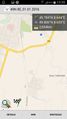
| Fri 1 Jan 2016 in 49,8: 49.7836848, 8.6439332 geohashing.info google osm bing/os kml crox |
Location
In a wood near Seeheim
Participants
Plans
Q-Owl and Q-Owla
Drive near the hashpoint (about 12:30) , find it, walk back to the car, find some caches and drive home.
Yakamoz and Rincewind
We don't want to miss the first geohash in 2016 which is very close to us. Drive near the hashpoint (about 14:00), walk there, drive back home and have a New Year's lunch.
Cuxi and tads
Drive near the hashpoint (about 16:30), find it, find some geocache and drive home.
Expedition
Q-Owl and Q-Owla
We reached the hashpoint about 12:45, found it, marked the tree next to the hp, went back to the car and found two caches today: GC603CT "Mystery Cache, I'm gone" (distance 900 m) and GC34TMY "Paradies der Libellen" (paradise of the dragonflies).
Yakamoz and Rincewind
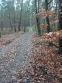
We parked next to allotment gardens and walked into the forest. The geohash has been located on a forest track. We did our geohash dance and took some photos. Unfortunately, we didn't see Q-Owl's marker. On our way back we a pony behind a fence accompanied us. It was a very easy and close geohash for us!
We wish all geohashers a happy and great new year with many successful geohashes! We hope to meet you at next geohash points. In particular, we hope to geohash together with Mampfred, EmmJay and LadyBB again this year ;-)
Cuxi and tads
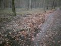
Happy new year everybody! We went to the hashpoint at 16:30, but did not recognize any marks at the location as it began to dawn already. We thus put a wooden X on the ground next to the trail. On the pictures that we took, we now have found the "xkcd" mark by Q-Owl and Q-Owla. Additionally we discovered GC3ACCJ "Waldschrats Geheimnis" (distance 370m).
Tracklog
??
Photos
Q-Owl and Q-Owla
Proof 0.36 m ;-)
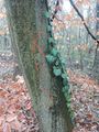
Marked tree next to the hashpoint.
View W

View E

Grin²


Yakamoz and Rincewind
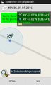
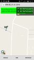
we only had 2,6 km to go
very close to the point

Yakamoz watching a woodpecker work a tree next to the hashpoint.
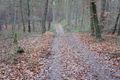
Nice view down the path that led us to the hash.

Woohooo!
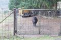
The pony living 50m from the hash, with a very barky white German Shepherd and some chicken as neighbours.


Cuxi and tads

proof
additional mark


Achievements
Q-Owl, Q-Owla, Yakamoz, Rincewind, tads and Cuxi earned the Land geohash achievement
|
Q-Owl, Q-Owla, Yakamoz, Rincewind, tads and Cuxi earned the Avoid Each Other Achievement
|