Difference between revisions of "2016-01-14 49 8"
imported>DODO (→Location) |
imported>FippeBot m (Location) |
||
| (5 intermediate revisions by one other user not shown) | |||
| Line 25: | Line 25: | ||
<!-- who attended: If you link to your wiki user name in this section, your expedition will be picked up by the various statistics generated for geohashing. You may use three tildes ~ as a shortcut to automatically insert the user signature of the account you are editing with. | <!-- who attended: If you link to your wiki user name in this section, your expedition will be picked up by the various statistics generated for geohashing. You may use three tildes ~ as a shortcut to automatically insert the user signature of the account you are editing with. | ||
--> | --> | ||
| + | [[User:DODO|DODO]] | ||
| − | == | + | == Expedition == |
| − | + | I saw that todays hashpoint was near my way to the office, and so I decided to go there on my bull, if the weather would be fine (it was raining all day for the last three days). | |
| + | |||
| + | There were no clouds this morning and so nothing could stop me (OK, it has been a very cold night and the streets were icy and slippery. I had to ride slower than usual.) | ||
| + | |||
| + | I had to ride eastwards in the direction of the Odenwald and when I came near the hashpoint the heaven over the valley of the Neckar got very bright because the sun came up there. So I got the idea to gain a sunrise-achievement and hurried on to reach the hash before the sun did. | ||
| − | + | I reached the fence of the barracks at 8:20. Officially sunrise was at 8:15 but the sun was still hidden behind the mountains of the Odenwald and (at this particular place) behind the military buildings. I left the bull at the fence and walked almost 100 m into the ploughed field. After almost no dance I reached a zero (that was already gone again when I took the picture). I took several pictures, went back to my bull and continued the ride. I was still at the hash field when I left the shadow of the barracks and I made a short stop to take a picture for the proof of the sunrise. | |
| − | |||
| + | At 8:45 I reached the office. That is the street in front of the office, but when I tried to turn into the entrance, the bull lost its grip and I fell. Yes, it was still slippery :-( | ||
== Tracklog == | == Tracklog == | ||
<!-- if your GPS device keeps a log, you may post a link here --> | <!-- if your GPS device keeps a log, you may post a link here --> | ||
| + | [https://www.komoot.de/tour/7702842 29 KM bullriding] | ||
== Photos == | == Photos == | ||
| Line 40: | Line 46: | ||
--> | --> | ||
<gallery perrow="5"> | <gallery perrow="5"> | ||
| + | Image:2016-01-14_49_8-1.jpg|some of the barracks... | ||
| + | Image:2016-01-14_49_8-9.jpg|... here with the bull in the foreground | ||
| + | Image:2016-01-14_49_8-2.jpg|the hash is 95m ... | ||
| + | Image:2016-01-14_49_8-3.jpg|... in the opposite direction | ||
| + | Image:2016-01-14_49_8-4.jpg|at the hash (it showed a 0 a second earlier) | ||
| + | Image:2016-01-14_49_8-5.jpg|view to the west | ||
| + | Image:2016-01-14_49_8-6.jpg|view to the hasher | ||
| + | Image:2016-01-14_49_8-7.jpg|view to the east(mind the two trees) | ||
| + | Image:2016-01-14_49_8-8.jpg|the trees some minutes later | ||
</gallery> | </gallery> | ||
| Line 46: | Line 61: | ||
<!-- Add any achievement ribbons you earned below, or remove this section --> | <!-- Add any achievement ribbons you earned below, or remove this section --> | ||
| − | + | I'm pretty sure that it was below 0 but I've no proof of that. | |
| − | |||
| − | |||
| − | + | {{land geohash | |
| − | + | | latitude = 49 | |
| − | + | | longitude = 8 | |
| − | + | | date = 2016-01-14 | |
| + | | name = DODO | ||
| + | }} | ||
| − | + | {{Sunrise geohash | |
| + | | latitude = 49 | ||
| + | | longitude = 8 | ||
| + | | date = 2016-01-14 | ||
| + | | name = DODO | ||
| + | | image = 2016-01-14_49_8-8.jpg | ||
| + | }} | ||
| − | |||
[[Category:Expeditions]] | [[Category:Expeditions]] | ||
| − | + | ||
[[Category:Expeditions with photos]] | [[Category:Expeditions with photos]] | ||
| − | + | ||
| − | |||
| − | |||
| − | |||
| − | |||
[[Category:Coordinates reached]] | [[Category:Coordinates reached]] | ||
| − | + | {{location|DE|BW|HD|city=true}} | |
| − | |||
| − | |||
| − | |||
| − | |||
| − | |||
| − | |||
| − | |||
| − | |||
| − | |||
| − | |||
| − | |||
| − | |||
| − | |||
| − | |||
| − | |||
| − | |||
| − | |||
Latest revision as of 06:28, 15 August 2019
| Thu 14 Jan 2016 in 49,8: 49.3728991, 8.6191584 geohashing.info google osm bing/os kml crox |
Location
A field next to the former american casern Patrick-Henry-Village in Heidelberg.
Participants
Expedition
I saw that todays hashpoint was near my way to the office, and so I decided to go there on my bull, if the weather would be fine (it was raining all day for the last three days).
There were no clouds this morning and so nothing could stop me (OK, it has been a very cold night and the streets were icy and slippery. I had to ride slower than usual.)
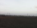
I had to ride eastwards in the direction of the Odenwald and when I came near the hashpoint the heaven over the valley of the Neckar got very bright because the sun came up there. So I got the idea to gain a sunrise-achievement and hurried on to reach the hash before the sun did.
I reached the fence of the barracks at 8:20. Officially sunrise was at 8:15 but the sun was still hidden behind the mountains of the Odenwald and (at this particular place) behind the military buildings. I left the bull at the fence and walked almost 100 m into the ploughed field. After almost no dance I reached a zero (that was already gone again when I took the picture). I took several pictures, went back to my bull and continued the ride. I was still at the hash field when I left the shadow of the barracks and I made a short stop to take a picture for the proof of the sunrise.
At 8:45 I reached the office. That is the street in front of the office, but when I tried to turn into the entrance, the bull lost its grip and I fell. Yes, it was still slippery :-(
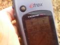
Tracklog
Photos
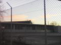
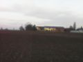
some of the barracks...
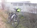
... here with the bull in the foreground
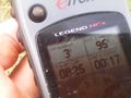
the hash is 95m ...
... in the opposite direction
at the hash (it showed a 0 a second earlier)
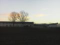
view to the west

view to the hasher
view to the east(mind the two trees)
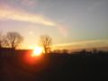
the trees some minutes later


Achievements
I'm pretty sure that it was below 0 but I've no proof of that.
DODO earned the Land geohash achievement
|
DODO earned the Sunrise Geohash Achievement
|