Difference between revisions of "2016-01-29 52 1"
From Geohashing
imported>Sourcerer m ([live picture] Arrival proof. [http://www.openstreetmap.org/?lat=52.55965054&lon=1.14774406&zoom=16&layers=B000FTF @52.5597,1.1477]) |
imported>Sourcerer m ([live picture] No entry - oops. [http://www.openstreetmap.org/?lat=52.55750477&lon=1.14873648&zoom=16&layers=B000FTF @52.5575,1.1487]) |
||
| Line 27: | Line 27: | ||
Image:2016-01-29_52_1_Sourcerer_1454089249407.jpg | Arrival proof. [http://www.openstreetmap.org/?lat=52.55965054&lon=1.14774406&zoom=16&layers=B000FTF @52.5597,1.1477] | Image:2016-01-29_52_1_Sourcerer_1454089249407.jpg | Arrival proof. [http://www.openstreetmap.org/?lat=52.55965054&lon=1.14774406&zoom=16&layers=B000FTF @52.5597,1.1477] | ||
| + | |||
| + | Image:2016-01-29_52_1_Sourcerer_1454089850418.jpg | No entry - oops. [http://www.openstreetmap.org/?lat=52.55750477&lon=1.14873648&zoom=16&layers=B000FTF @52.5575,1.1487] | ||
</gallery> | </gallery> | ||
Revision as of 17:52, 29 January 2016
| Fri 29 Jan 2016 in Norwich, UK: 52.5596401, 1.1477662 geohashing.info google osm bing/os kml crox |
Location
A field next to a petroleum distribution depot, east of Wymondham, Norfolk, UK.
Participants
Plans
There are no reachable points to pair this with. Set out at dusk.
Expedition
Photos
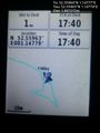
Arrival proof. @52.5597,1.1477
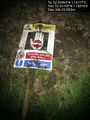
No entry - oops. @52.5575,1.1487


Achievements
Expeditions and Plans
| 2016-01-29 | ||
|---|---|---|
| Portland, Oregon | Jim | North of Hillsboro very close to Hwy 26 |
| Stuttgart, Germany | Ekorren | located in Pliezhausen. |
| Norwich, United Kingdom | Sourcerer | A quarry next to a petroleum distribution depot, east of Wymondham, Norfolk... |
Sourcerer's Expedition Links
2016-01-23 52 0 - 2016-01-29 52 1 - 2016-01-31 52 1 - KML file download of Sourcerer's expeditions for use with Google Earth.