Difference between revisions of "2016-02-10 60 25"
imported>PPP (→Plans) |
|||
| (10 intermediate revisions by 6 users not shown) | |||
| Line 14: | Line 14: | ||
| date=2016-02-10 | | date=2016-02-10 | ||
}} | }} | ||
| − | + | __NOTOC__ | |
<!-- edit as necessary --> | <!-- edit as necessary --> | ||
| − | |||
== Location == | == Location == | ||
<!-- where you've surveyed the hash to be --> | <!-- where you've surveyed the hash to be --> | ||
| Line 25: | Line 24: | ||
<!-- who attended: If you link to your wiki user name in this section, your expedition will be picked up by the various statistics generated for geohashing. You may use three tildes ~ as a shortcut to automatically insert the user signature of the account you are editing with. | <!-- who attended: If you link to your wiki user name in this section, your expedition will be picked up by the various statistics generated for geohashing. You may use three tildes ~ as a shortcut to automatically insert the user signature of the account you are editing with. | ||
--> | --> | ||
| − | + | *[[User:Sgt pepper|Sgt pepper]] | |
| + | *UndeadPriest | ||
== Plans == | == Plans == | ||
| + | ===PPP=== | ||
<!-- what were the original plans --> | <!-- what were the original plans --> | ||
| − | Easily reachable by public transport - Bus 550 from Itäkeskus | + | Easily reachable by public transport [http://www.reittiopas.fi/?showsearchformsaved=hide&from_in=It%C3%A4keskus%2C+Helsinki&from=poi*It%C3%A4keskus%2C+Helsinki*2559974*6678128&fromSelect=poi*It%C3%A4keskus%2C+Helsinki*2559974*6678128&via_in=&via=&via_time=0&to_in=Sopulirinne+3%2C+Helsinki&to=address*Sopulirinne+3%2C+Helsinki*2557999.375*6679078.25&hour=16&minute=17&timetype=arrival&date_cb=tomorrow&day=10&month=2&year=2016&cmargin=3&wspeed=70&method=1&stz=0&mc1=0&mc2=0&mc3=0&mc4=0&mc5=0&mc6=0&mc0=1&nroutes=3&gotoHash=# - Bus 550 from Itäkeskus] |
| + | [[File:2016-02-10 60 25-approach.JPG]] | ||
== Expedition == | == Expedition == | ||
| + | ===Sgt pepper=== | ||
<!-- how it all turned out. your narrative goes here. --> | <!-- how it all turned out. your narrative goes here. --> | ||
| + | It seemed like a really easy geohash. We live nearby and the hash would be easily reached by foot. Just a little evening walk in the rain. Boy oh boy, we were wrong. | ||
| − | + | The path which goes around the forest is a ski track in the winter. Snow is mostly melted already and most of the roads aren't even icy anymore, but this former ski track was still thickly covered with ice and it had not been maintenanced at all. So it was all ice, and not been sanded at all. | |
| − | + | ||
| + | So we had to proceed carefully. With little baby steps. Slowly. Very very slowly. | ||
| + | |||
| + | Finally we reached a steep slope and we could not go on. Just no way. Heeeell no. We would have needed an ice axe to get up there! | ||
| + | |||
| + | So we had to turn to the forest. There also would have been a small pathway, but it was also covered with ice and water on top of that, so we mainly walked where there was snow and no trail. It was dark. And wet. And we were still moving slowly. But we finally made it. | ||
| + | |||
| + | We took another route back. Jeez, we would have came that way to the hash if we knew how awful the big trail was. The way back was also a bit icy, and in the end there was a tricky brook crossing, but compared to the other route this one was a lot more pleasant. | ||
| + | |||
| + | With wet socks we returned home around 18.40. | ||
== Photos == | == Photos == | ||
<!-- Insert pictures between the gallery tags using the following format: | <!-- Insert pictures between the gallery tags using the following format: | ||
--> | --> | ||
| + | ===Sgt pepper=== | ||
<gallery perrow="5"> | <gallery perrow="5"> | ||
| + | Image: 2016-02-10_60_25_1.jpg| Ice ice baby | ||
| + | Image: 2016-02-10_60_25_2.jpg| Nope. | ||
| + | Image: 2016-02-10_60_25_3.jpg| Coordinates at the hash | ||
| + | Image: 2016-02-10_60_25_4.jpg| The camera flash made me look high as hell, so I had to look the other way. | ||
| + | Image: 2016-02-10_60_25_5.png| Tracklog on map. Yellow arrow points the hash, white arrow points the icy slope | ||
</gallery> | </gallery> | ||
| Line 49: | Line 68: | ||
<!-- Add any achievement ribbons you earned below, or remove this section --> | <!-- Add any achievement ribbons you earned below, or remove this section --> | ||
| − | + | {{Walk geohash | |
| − | |||
| − | |||
| − | |||
| − | |||
| − | + | | latitude = 60 | |
| − | + | | longitude = 25 | |
| − | + | | date = 2016-02-10 | |
| − | + | | name = Sgt pepper | |
| + | | distance = 3.3 km | ||
| + | }} | ||
[[Category:Expeditions]] | [[Category:Expeditions]] | ||
| − | |||
[[Category:Expeditions with photos]] | [[Category:Expeditions with photos]] | ||
| − | |||
[[Category:Coordinates reached]] | [[Category:Coordinates reached]] | ||
| + | {{location|FI|18}} | ||
Latest revision as of 09:52, 7 September 2021
| Wed 10 Feb 2016 in 60,25: 60.2217816, 25.0418432 geohashing.info google osm bing/os kml crox |
Location
In the hill crest in Viikki
Participants
- Sgt pepper
- UndeadPriest
Plans
PPP
Easily reachable by public transport - Bus 550 from Itäkeskus

Expedition
Sgt pepper
It seemed like a really easy geohash. We live nearby and the hash would be easily reached by foot. Just a little evening walk in the rain. Boy oh boy, we were wrong.
The path which goes around the forest is a ski track in the winter. Snow is mostly melted already and most of the roads aren't even icy anymore, but this former ski track was still thickly covered with ice and it had not been maintenanced at all. So it was all ice, and not been sanded at all.
So we had to proceed carefully. With little baby steps. Slowly. Very very slowly.
Finally we reached a steep slope and we could not go on. Just no way. Heeeell no. We would have needed an ice axe to get up there!
So we had to turn to the forest. There also would have been a small pathway, but it was also covered with ice and water on top of that, so we mainly walked where there was snow and no trail. It was dark. And wet. And we were still moving slowly. But we finally made it.
We took another route back. Jeez, we would have came that way to the hash if we knew how awful the big trail was. The way back was also a bit icy, and in the end there was a tricky brook crossing, but compared to the other route this one was a lot more pleasant.
With wet socks we returned home around 18.40.
Photos
Sgt pepper
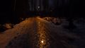
Ice ice baby
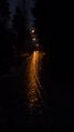
Nope.
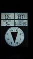
Coordinates at the hash

The camera flash made me look high as hell, so I had to look the other way.
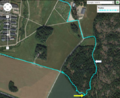
Tracklog on map. Yellow arrow points the hash, white arrow points the icy slope


Achievements
Sgt pepper earned the Walk geohash Achievement
|