Difference between revisions of "2016-02-11 52 5"
imported>FippeBot m (Location) |
m |
||
| Line 24: | Line 24: | ||
<!-- who attended: If you link to your wiki user name in this section, your expedition will be picked up by the various statistics generated for geohashing. You may use three tildes ~ as a shortcut to automatically insert the user signature of the account you are editing with. | <!-- who attended: If you link to your wiki user name in this section, your expedition will be picked up by the various statistics generated for geohashing. You may use three tildes ~ as a shortcut to automatically insert the user signature of the account you are editing with. | ||
--> | --> | ||
| + | *[[User:xnyhps|xnyhps]] | ||
== Plans == | == Plans == | ||
Latest revision as of 14:51, 18 March 2022
| Thu 11 Feb 2016 in 52,5: 52.1090362, 5.3089221 geohashing.info google osm bing/os kml crox |
Location
Near Soesterberg.
Participants
Plans
xnyhps
Looks like it's close to a path in a forest ~7 km from where I live. Weather is also looking nice, so I'm going to try to get there.
Expedition
xnyhps
Turns out none of the tracks the map had shown me were easy to cycle on, I had to get off my bicycle a few times to go around a pool of mud. At some point I was walking on a narrow forest path with lots of branches on the path really wishing I had left my bike behind earlier.
The hash point itself was inside an area that was cleared recently, so the last ~50m were easy to do. I got pretty close, but despite the clear weather and few trees my GPS accuracy wasn't great.
On the way back I was tempted to make my way though some bushes to a sand road parallel to the path I was on, but decided not to. A bit later it turned out that area is part of a military shooting range. Oops. I did spot a deer on the shooting range area, which was quite cool.
Tracklog
Photos
Proof
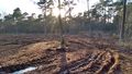
View of the hashpoint
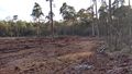
View from the hashpoint
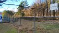
Scary signs, and a deer


