Difference between revisions of "2016-02-12 49 8"
imported>DODO (→Achievements) |
imported>FippeBot m (Location) |
||
| Line 72: | Line 72: | ||
[[Category:Coordinates reached]] | [[Category:Coordinates reached]] | ||
| + | {{location|DE|BW|MA}} | ||
Latest revision as of 06:40, 15 August 2019
| Fri 12 Feb 2016 in 49,8: 49.4185127, 8.5528699 geohashing.info google osm bing/os kml crox |
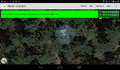
Location
In the Rheinauer forest near a bridlepath.
Participants
Plans
Very close to my office. So I'll go there after work.
Drive to Rheinau by car and walk the rest.
Expedition
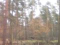
It was just a 3 KM drive to Rheinau station and a 4 KM walk to the hash and back. The walk lead mostly through the forest, so it was quite idyllic, although I had to cross two motorways twice.I had to follow a bridle path for 150 m which was muddy, but that was no problem. The hash lay 6m next to the bridlepath. I took some pictures, builded a large X and went back to my car. There was a footpath next to the bridle path so I didn't have to disturb any horses (I saw two of them, one before I entered the bridle path and one at the hash, but I was to slow to take a proof-picture of his hash-success).
Tracklog
4 KM walking (and 3 KM by car which are not recorded)
Photos
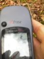
proof
better proof
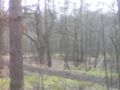
the bridle path seen fron the hash
the other direction
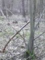
a X marks the place

a face
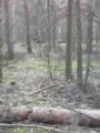
a horseman
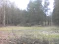
The dune of Rheinau. What looks like a muddy place is ...

...a nature protection area
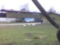
this farm was a casern 20 years ago (the geese were bigger that time)


Achievements
DODO earned the Land geohash achievement
|