Difference between revisions of "2016-02-12 49 9"
imported>Klaus (plans) |
imported>Klaus (expedition) |
||
| Line 28: | Line 28: | ||
== Expedition == | == Expedition == | ||
| − | + | The intention behind this one was just "Cache the 49 9 graticule". | |
| + | The good thing was that it was not that far from the A81 and nobody had contacted me wanting drive on Friday with me (I always share the ride via internet to save money), so I could easily make this detour. | ||
| + | The bad thing was that I noticed it at work, immediately before leaving. | ||
| + | So I didn't have time to pack anything for the "expedition". | ||
| − | + | So I left the A81 on exit 6 "Osterburken" and drove to Unterwittstadt. I arrived at around 20:10 and parked [https://www.google.de/maps/place/49%C2%B025'01.3%22N+9%C2%B033'02.5%22E 200m from the geohash]. | |
| − | + | Then I started to walk on the meadow next to the Hasselbach in the complete darkness, the moon was only around one third and I had no light except the screen of my two smartphones (both without a camera light!). | |
| + | |||
| + | Unfortunately, the hash was quite close to the river and I noticed the meadow getting more muddy and muddy while getting close to the geohash. | ||
| + | I was able to get to 10m, but unfortunately the area in the meadow where the geohash was covered with a few centimeters of water after the heavy rainfalls. | ||
| + | |||
| + | I decided not to go insane and instead call it a failure :( | ||
| + | I drove to the exit 5 "Boxberg" and continued my drive. | ||
| + | Damn you [[49,9]] for having to come again... | ||
== Photos == | == Photos == | ||
| − | |||
| − | |||
| − | |||
<gallery perrow="5"> | <gallery perrow="5"> | ||
| + | Image:2016-02-12 49 9 proof.jpg | The only non-black picture: the proof | ||
</gallery> | </gallery> | ||
== Achievements == | == Achievements == | ||
| − | |||
| − | |||
| − | |||
| − | |||
| − | |||
| − | |||
| − | |||
| − | |||
| − | |||
| − | |||
| − | |||
| − | + | {{Template:Mnb geohash | |
| + | | latitude = 49 | ||
| + | | longitude = 9 | ||
| + | | date = 2016-02-12 | ||
| + | | name = [[User:Klaus|Klaus]] | ||
| + | }} | ||
| − | |||
[[Category:Expeditions]] | [[Category:Expeditions]] | ||
| − | |||
[[Category:Expeditions with photos]] | [[Category:Expeditions with photos]] | ||
| − | |||
| − | |||
| − | |||
| − | |||
| − | |||
| − | |||
| − | |||
| − | |||
| − | |||
[[Category:Coordinates not reached]] | [[Category:Coordinates not reached]] | ||
| − | |||
| − | |||
[[Category:Not reached - Mother Nature]] | [[Category:Not reached - Mother Nature]] | ||
| − | |||
| − | |||
| − | |||
| − | |||
| − | |||
| − | |||
| − | |||
| − | |||
| − | |||
| − | |||
| − | |||
Revision as of 21:53, 14 February 2016
| Fri 12 Feb 2016 in 49,9: 49.4185127, 9.5528699 geohashing.info google osm bing/os kml crox |
Location
between Unter- and Oberwittstadt, hopefully not IN the Hasselbach
Participants
Plans
I'm driving along the A81 tonight. I'll make a short detour by car and will probably arrive there around 19:30 to 20:00.
Expedition
The intention behind this one was just "Cache the 49 9 graticule". The good thing was that it was not that far from the A81 and nobody had contacted me wanting drive on Friday with me (I always share the ride via internet to save money), so I could easily make this detour. The bad thing was that I noticed it at work, immediately before leaving. So I didn't have time to pack anything for the "expedition".
So I left the A81 on exit 6 "Osterburken" and drove to Unterwittstadt. I arrived at around 20:10 and parked 200m from the geohash. Then I started to walk on the meadow next to the Hasselbach in the complete darkness, the moon was only around one third and I had no light except the screen of my two smartphones (both without a camera light!).
Unfortunately, the hash was quite close to the river and I noticed the meadow getting more muddy and muddy while getting close to the geohash. I was able to get to 10m, but unfortunately the area in the meadow where the geohash was covered with a few centimeters of water after the heavy rainfalls.
I decided not to go insane and instead call it a failure :( I drove to the exit 5 "Boxberg" and continued my drive. Damn you 49,9 for having to come again...
Photos
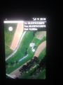
The only non-black picture: the proof
