Difference between revisions of "2016-02-25 54 -2"
From Geohashing
imported>Angel ([live picture]Is there an achievement for this yet? [http://www.openstreetmap.org/?lat=54.08818130&lon=-2.80508820&zoom=16&layers=B000FTF @54.0882,-2.8051]) |
m |
||
| (3 intermediate revisions by 3 users not shown) | |||
| Line 24: | Line 24: | ||
<!-- who attended: If you link to your wiki user name in this section, your expedition will be picked up by the various statistics generated for geohashing. You may use three tildes ~ as a shortcut to automatically insert the user signature of the account you are editing with. | <!-- who attended: If you link to your wiki user name in this section, your expedition will be picked up by the various statistics generated for geohashing. You may use three tildes ~ as a shortcut to automatically insert the user signature of the account you are editing with. | ||
--> | --> | ||
| + | *[[User:Angel|Angel]] | ||
== Plans == | == Plans == | ||
| Line 45: | Line 46: | ||
Image:2016-02-25_54_-2_Angel_1456405777036.jpg|Is there an achievement for this yet? [http://www.openstreetmap.org/?lat=54.08818130&lon=-2.80508820&zoom=16&layers=B000FTF @54.0882,-2.8051] | Image:2016-02-25_54_-2_Angel_1456405777036.jpg|Is there an achievement for this yet? [http://www.openstreetmap.org/?lat=54.08818130&lon=-2.80508820&zoom=16&layers=B000FTF @54.0882,-2.8051] | ||
| + | |||
| + | Image:2016-02-25_54_-2_Angel_1456406303281.jpg|Made it ☺ | ||
</gallery> | </gallery> | ||
== Achievements == | == Achievements == | ||
{{#vardefine:ribbonwidth|800px}} | {{#vardefine:ribbonwidth|800px}} | ||
| − | |||
| − | |||
| − | |||
| − | |||
| − | |||
| − | |||
| − | |||
| − | |||
| − | |||
| − | |||
| − | |||
| − | |||
| − | |||
[[Category:Expeditions]] | [[Category:Expeditions]] | ||
| − | |||
[[Category:Expeditions with photos]] | [[Category:Expeditions with photos]] | ||
| − | |||
| − | |||
| − | |||
| − | |||
| − | |||
[[Category:Coordinates reached]] | [[Category:Coordinates reached]] | ||
| − | + | {{location|GB|ENG|LAN}} | |
| − | |||
| − | |||
| − | |||
| − | |||
| − | |||
| − | |||
| − | |||
| − | |||
| − | |||
| − | |||
| − | |||
| − | |||
| − | |||
| − | |||
| − | |||
| − | |||
| − | |||
Latest revision as of 14:50, 18 March 2022
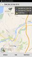
| Thu 25 Feb 2016 in 54,-2: 54.0889093, -2.8049746 geohashing.info google osm bing/os kml crox |
Location
Participants
Plans
Expedition
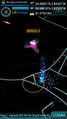
Tracklog
Photos
I think I can do this...
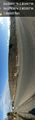
Some interesting sights on the way; a new motorway bridge, and a road temporarily closed to pedestrians @54.0794,-2.8039
Is there an achievement for this yet? @54.0882,-2.8051
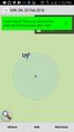
Made it ☺


