Difference between revisions of "2016-03-01 49 8"
From Geohashing
imported>DODO (→Tracklog) |
imported>FippeBot m (Location) |
||
| (2 intermediate revisions by one other user not shown) | |||
| Line 45: | Line 45: | ||
Image:2012-##-## ## ## Alpha.jpg | Witty Comment | Image:2012-##-## ## ## Alpha.jpg | Witty Comment | ||
--> | --> | ||
| − | <gallery perrow=" | + | <gallery perrow="4"> |
| + | Image:2016-03-01_49_8-1.jpg|exotic garden in Limburgerhof | ||
| + | Image:2016-03-01_49_8-2.jpg|view to the north | ||
| + | Image:2016-03-01_49_8-3.jpg|to the east, | ||
| + | Image:2016-03-01_49_8-4.jpg|the south | ||
| + | Image:2016-03-01_49_8-5.jpg|the ground | ||
| + | Image:2016-03-01_49_8-6.jpg|the hasher | ||
| + | Image:2016-03-01_49_8-7.png|proof | ||
</gallery> | </gallery> | ||
| Line 52: | Line 59: | ||
<!-- Add any achievement ribbons you earned below, or remove this section --> | <!-- Add any achievement ribbons you earned below, or remove this section --> | ||
| − | + | {{land geohash | |
| − | + | | latitude = 49 | |
| − | + | | longitude = 8 | |
| + | | date = 2016-03-01 | ||
| + | | name = DODO | ||
| + | }} | ||
| − | |||
| − | |||
| − | |||
| − | |||
| − | |||
| − | |||
| − | |||
| − | |||
[[Category:Expeditions]] | [[Category:Expeditions]] | ||
| − | |||
[[Category:Expeditions with photos]] | [[Category:Expeditions with photos]] | ||
| − | |||
| − | |||
| − | |||
| − | |||
| − | |||
[[Category:Coordinates reached]] | [[Category:Coordinates reached]] | ||
| − | + | {{location|DE|RP|RP}} | |
| − | |||
| − | |||
| − | |||
| − | |||
| − | |||
| − | |||
| − | |||
| − | |||
| − | |||
| − | |||
| − | |||
| − | |||
| − | |||
| − | |||
| − | |||
| − | |||
| − | |||
Latest revision as of 06:50, 15 August 2019
| Tue 1 Mar 2016 in 49,8: 49.4280396, 8.3775138 geohashing.info google osm bing/os kml crox |
Location
A field next to Limburgerhof.
Participants
Plans
Have a quick drive by on my way to the office.
Expedition
This one was very easy. I did not drive on the Autobahn A61 but continued my drive on the B9 until Limburgerhof. I left little car in a residential area and had a 500m walk to the hash. There was a very nice garden with exotic plants on my way.
The hash field was ploughed but very dry. I could easily walk to the hash, took some pictures and walked back to the car. All in all it was a 22 KM detour by car and a 1 KM walk. The hash needed half an hour.
Tracklog
Photos
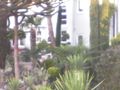
exotic garden in Limburgerhof
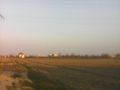
view to the north
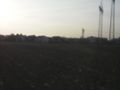
to the east,
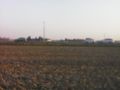
the south
- Error creating thumbnail: Unable to save thumbnail to destination
the ground

the hasher
proof


Achievements
DODO earned the Land geohash achievement
|