Difference between revisions of "2016-03-15 40 -73"
imported>OtherJack (→Expedition: wrote up my expedition and gave us separate headings) |
imported>FippeBot m (Location) |
||
| (4 intermediate revisions by one other user not shown) | |||
| Line 1: | Line 1: | ||
| − | |||
| − | |||
| − | |||
| − | |||
| − | |||
| − | |||
| − | |||
| − | |||
| − | |||
| − | |||
{{meetup graticule | {{meetup graticule | ||
| lat=40 | | lat=40 | ||
| Line 19: | Line 9: | ||
== Location == | == Location == | ||
| − | |||
In Central Park! But about 8m behind a fence | In Central Park! But about 8m behind a fence | ||
| Line 32: | Line 21: | ||
== Expedition == | == Expedition == | ||
| − | |||
=== Jevanyn (midday) === | === Jevanyn (midday) === | ||
| Line 55: | Line 43: | ||
But then he didn't seem to care at all... just kept going about his trash collection and eventually drove off. So, looking around to make sure his co-workers weren't coming, I climbed back over one more time and finally got the darn picture. Now you will all believe me, Internet. | But then he didn't seem to care at all... just kept going about his trash collection and eventually drove off. So, looking around to make sure his co-workers weren't coming, I climbed back over one more time and finally got the darn picture. Now you will all believe me, Internet. | ||
| − | One more embarassing fence-scaling and I was back with my bike, up the dusky scenic east side of the park and home in a few more minutes. | + | One more embarassing fence-scaling and I was back with my bike, up the dusky scenic east side of the park, past the Metropolitan Art Museum, and home in a few more minutes. |
== Tracklog == | == Tracklog == | ||
| − | |||
| − | == Photos == | + | == Photos == |
| − | + | ||
| − | + | === OtherJack === | |
| − | + | ||
<gallery perrow="5"> | <gallery perrow="5"> | ||
| + | Image:2016-03-15 19.03.27.jpg | The Pain Quotidien location Jevanyn mentioned | ||
| + | Image:2016-03-15 19.03.31.jpg | Looking East | ||
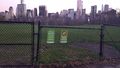
| + | Image:2016-03-15 19.03.36.jpg | Looking South towards the hashpoint (foreground) and Midtown | ||
| + | Image:2016-03-15 19.03.48.jpg | Looking Southwest towards the West Side and Trump-land | ||
| + | Image:2016-03-15 19.09.09.jpg | "Closed" but friendly looking | ||
| + | Image:2016-03-15 19.11.11.jpg | 22.8 feet outside the fence... | ||
| + | Image:2016-03-15 19.16.31.jpg | ...4.something feet inside the fence! | ||
| + | Image:2016-03-15 19.16.46.jpg | Back at my bike from the point | ||
</gallery> | </gallery> | ||
== Achievements == | == Achievements == | ||
{{#vardefine:ribbonwidth|800px}} | {{#vardefine:ribbonwidth|800px}} | ||
| − | + | {{Bicycle geohash | latitude = 40 | longitude = -73 | date = 2016-03-15 | name = [[User:OtherJack|OtherJack]] | distance = about 5km (each way) | image = 2016-03-15 19.13.39.jpg}} | |
| − | |||
| − | |||
| − | |||
| − | [[ | ||
| − | |||
| − | |||
| − | |||
| − | |||
| − | |||
| − | |||
| − | |||
[[Category:Expeditions]] | [[Category:Expeditions]] | ||
| − | |||
[[Category:Expeditions with photos]] | [[Category:Expeditions with photos]] | ||
| − | |||
| − | |||
| − | |||
| − | |||
| − | |||
[[Category:Coordinates reached]] | [[Category:Coordinates reached]] | ||
| − | + | {{location|US|NY|NE}} | |
| − | |||
| − | |||
| − | |||
| − | |||
| − | |||
| − | |||
| − | |||
| − | |||
| − | |||
| − | |||
| − | |||
| − | |||
| − | |||
| − | |||
| − | |||
| − | |||
| − | |||
Latest revision as of 06:55, 15 August 2019
| Tue 15 Mar 2016 in 40,-73: 40.7728512, -73.9745263 geohashing.info google osm bing/os kml crox |
Location
In Central Park! But about 8m behind a fence
Participants
Plans
Expedition
Jevanyn (midday)
- Central Park near Sheep Meadow. I happen to be in New York this morning, I'll have to see how long it takes to get to that part of town -- Jevanyn (talk) @40.7273,-74.1714 09:43, 15 March 2016 (EDT)
- Did you make it? I just noticed this now... working from home today so could try to meet you if you haven't already gotten there! -- OtherJack (talk) 12:03, 15 March 2016 (EDT)
- All the fields are fenced off for reseeding -- Jevanyn (talk) @40.7732,-73.9750 12:59, 15 March 2016 (EDT)
- Hashpoint inside le pain auotidien? -- Jevanyn (talk) @40.7729,-73.9743 13:03, 15 March 2016 (EDT)
OtherJack (evening)
I was going to just run there (5k or so) but feeling hungry and out of it so almost took the subway and then finally thought of biking down through the park, of course. Made it right around 7pm at dusk, Central Park was beautiful and warm, 56F (13.3C). Yellow GPS said the point was 25 feet behind (south of) the fence even at closest approach, and error was 11 feet, so investigated what looked like an opening a few meters west.
Unfortunately it was not an opening but just a squiggle in the fence, with signs saying the meadow was closed for the season. However the signs did not say no-trespassing or look particularly scary, so I figured I might as well climb it. Was harder than anticipated (I'm out of shape and was wearing big hi-top shoes) but finally made it over. Hashdanced backwards to the point, warily watching my bike which I'd leaned against the fence.
Finally got the thing to read 5 feet or so, tried taking pictures but I couldn't get the touchscreen to press on my phone! Odd angle and one finger I guess. Or I just suck at the 21st century. To make it worse a park ranger guy drove by outside the fence in his cart and warned me to leave. I didn't want to be in worse trouble so gave up on the GPS photo, took a shot of the fence for "proof", and clumsily climbed back over.
But then he didn't seem to care at all... just kept going about his trash collection and eventually drove off. So, looking around to make sure his co-workers weren't coming, I climbed back over one more time and finally got the darn picture. Now you will all believe me, Internet.
One more embarassing fence-scaling and I was back with my bike, up the dusky scenic east side of the park, past the Metropolitan Art Museum, and home in a few more minutes.
Tracklog
Photos
OtherJack
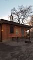
The Pain Quotidien location Jevanyn mentioned
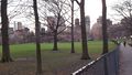
Looking East
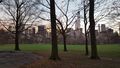
Looking South towards the hashpoint (foreground) and Midtown
Looking Southwest towards the West Side and Trump-land
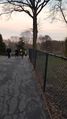
"Closed" but friendly looking
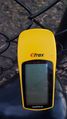
22.8 feet outside the fence...
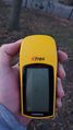
...4.something feet inside the fence!
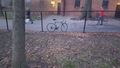
Back at my bike from the point


Achievements
OtherJack earned the Bicycle geohash achievement
|