Difference between revisions of "2016-03-31 -8 121"
imported>Felix Dance ([live picture]Flores virgin geohash success! Just north of Ende [http://www.openstreetmap.org/?lat=-8.80395140&lon=121.63407850&zoom=16&layers=B000FTF @-8.8040,121.6341]) |
m (per Renaming Proposal) |
||
| (9 intermediate revisions by 3 users not shown) | |||
| Line 1: | Line 1: | ||
| − | |||
| − | |||
| − | |||
| − | |||
| − | |||
| − | |||
| − | |||
| − | |||
| − | |||
| − | |||
{{meetup graticule | {{meetup graticule | ||
| lat=-8 | | lat=-8 | ||
| Line 20: | Line 10: | ||
== Location == | == Location == | ||
<!-- where you've surveyed the hash to be --> | <!-- where you've surveyed the hash to be --> | ||
| + | On the slope of a volcano north-west of Ende, on Flores, Indonesia. | ||
== Participants == | == Participants == | ||
<!-- who attended: If you link to your wiki user name in this section, your expedition will be picked up by the various statistics generated for geohashing. You may use three tildes ~ as a shortcut to automatically insert the user signature of the account you are editing with. | <!-- who attended: If you link to your wiki user name in this section, your expedition will be picked up by the various statistics generated for geohashing. You may use three tildes ~ as a shortcut to automatically insert the user signature of the account you are editing with. | ||
--> | --> | ||
| + | *[[User:Felix Dance|Felix Dance]] | ||
| − | == | + | == Expedition == |
| − | + | I'm on this month-long cycle tour of the Indonesian archepelago from Bali to Timor-Leste, as mentioned in earlier hash [[2016-03-19 -8 117]]. I woke up at 5:20 in my hotel in the rather shitty city of Ende in central Flores expecting to ride up Gunung Kelimutu, a local volcano, for a relatively short day of 52 kms, staying in a town on the side. | |
| − | + | But then of course I checked the geohahes. 8.8 kms away. And practically on a road. And I'd planned only half a day's ride. I did not even have to think about this. | |
| − | + | ||
| + | I quickly packed up, checked out and left three of my four panniers with reception while I rode my bike up the quiet rural road towards the hash. | ||
| + | |||
| + | It took me about an hour and a half to climb the 600m elevation of the hash, avoiding crappy road conditions, admiring the superb views of Ende (which is much nicer from above) and waving to excited school children, who looked like they would much rather spend the day doing what I was doing despite the hard work. | ||
| + | |||
| + | After not too long I was there. I warily plonked my bike on the ground and headed into the thick rainforest down a gully to the hash, 63m away. The dense foliage gave my GPS a lot of trouble, but after stepping on a few large spiders and shoving branches out of the way my hash-droid app showed me to be less than 3m away. I took some photos and climbed back up the gully to my bike. | ||
| + | |||
| + | Flying down the mountain, flinging mud and small stones up into my face, I got back to my panniers at the hotel. Here, with some regret, I discovered that Google Terrain-view showed that I'd been climbing an enormous volcano, and the hash to be only 200m or so from the lip of the caldera. What a shame I missed that view. Particularly in the light of having to wait two hours for road-works during the rest of my ride. | ||
| − | + | Total distance: 19kms. | |
| − | |||
== Photos == | == Photos == | ||
| Line 41: | Line 39: | ||
Image:2016-03-31_-8_121_Felix Dance_1459382301502.jpg|Flores virgin geohash success! Just north of Ende [http://www.openstreetmap.org/?lat=-8.80395140&lon=121.63407850&zoom=16&layers=B000FTF @-8.8040,121.6341] | Image:2016-03-31_-8_121_Felix Dance_1459382301502.jpg|Flores virgin geohash success! Just north of Ende [http://www.openstreetmap.org/?lat=-8.80395140&lon=121.63407850&zoom=16&layers=B000FTF @-8.8040,121.6341] | ||
| + | |||
| + | Image:Geohash 2016-03-31 -8 121 Ende.JPG|Ende from near the hash | ||
| + | |||
| + | Image:Geohash 2016-03-31 -8 121 Bike.JPG|My bike near the hash | ||
| + | |||
| + | Image:Geohash 2016-03-31 -8 121 Road.JPG|The road's closest approach | ||
</gallery> | </gallery> | ||
== Achievements == | == Achievements == | ||
| − | {{ | + | {{Graticule unlocked |
| − | + | ||
| + | | latitude = -8 | ||
| + | | longitude = 121 | ||
| + | | date = 2016-03-31 | ||
| + | | name = [[User:Felix Dance|Felix Dance]] | ||
| + | | image = Geohash 2016-03-31 -8 121 Ende.JPG | ||
| + | }} | ||
| − | + | {{bicycle geohash | |
| − | |||
| − | |||
| − | + | | latitude = -8 | |
| − | + | | longitude = 121 | |
| − | [[ | + | | date = 2016-03-31 |
| − | -- | + | | name = [[User:Felix Dance|Felix Dance]] |
| + | | distance = 19 kms | ||
| + | | bothways = true | ||
| + | | image = Geohash 2016-03-31 -8 121 Bike.JPG | ||
| + | }} | ||
<!-- If all those plans are never acted upon, change [[Category:Expedition planning]] to [[Category:Not reached - Did not attempt]]. --> | <!-- If all those plans are never acted upon, change [[Category:Expedition planning]] to [[Category:Not reached - Did not attempt]]. --> | ||
| − | |||
[[Category:Expeditions]] | [[Category:Expeditions]] | ||
| − | + | [[Category:Coordinates reached]] | |
[[Category:Expeditions with photos]] | [[Category:Expeditions with photos]] | ||
| − | + | {{location|ID|NU|NT}} | |
| − | |||
| − | |||
| − | |||
| − | |||
| − | |||
| − | |||
| − | |||
| − | |||
| − | |||
| − | |||
| − | |||
| − | |||
| − | |||
| − | |||
| − | |||
| − | |||
| − | |||
| − | |||
| − | |||
| − | |||
| − | |||
| − | |||
| − | |||
Latest revision as of 05:00, 20 March 2024
| Thu 31 Mar 2016 in -8,121: -8.8040197, 121.6340738 geohashing.info google osm bing/os kml crox |
Location
On the slope of a volcano north-west of Ende, on Flores, Indonesia.
Participants
Expedition
I'm on this month-long cycle tour of the Indonesian archepelago from Bali to Timor-Leste, as mentioned in earlier hash 2016-03-19 -8 117. I woke up at 5:20 in my hotel in the rather shitty city of Ende in central Flores expecting to ride up Gunung Kelimutu, a local volcano, for a relatively short day of 52 kms, staying in a town on the side.
But then of course I checked the geohahes. 8.8 kms away. And practically on a road. And I'd planned only half a day's ride. I did not even have to think about this.
I quickly packed up, checked out and left three of my four panniers with reception while I rode my bike up the quiet rural road towards the hash.
It took me about an hour and a half to climb the 600m elevation of the hash, avoiding crappy road conditions, admiring the superb views of Ende (which is much nicer from above) and waving to excited school children, who looked like they would much rather spend the day doing what I was doing despite the hard work.
After not too long I was there. I warily plonked my bike on the ground and headed into the thick rainforest down a gully to the hash, 63m away. The dense foliage gave my GPS a lot of trouble, but after stepping on a few large spiders and shoving branches out of the way my hash-droid app showed me to be less than 3m away. I took some photos and climbed back up the gully to my bike.
Flying down the mountain, flinging mud and small stones up into my face, I got back to my panniers at the hotel. Here, with some regret, I discovered that Google Terrain-view showed that I'd been climbing an enormous volcano, and the hash to be only 200m or so from the lip of the caldera. What a shame I missed that view. Particularly in the light of having to wait two hours for road-works during the rest of my ride.
Total distance: 19kms.
Photos

Flores virgin geohash success! Just north of Ende @-8.8040,121.6341
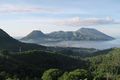
Ende from near the hash
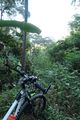
My bike near the hash
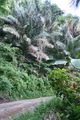
The road's closest approach


Achievements
Felix Dance earned the Graticule Unlocked Achievement
|
Felix Dance earned the Bicycle geohash achievement
|